Coble Mountain Topo Map California
To zoom in, hover over the map of Coble Mountain
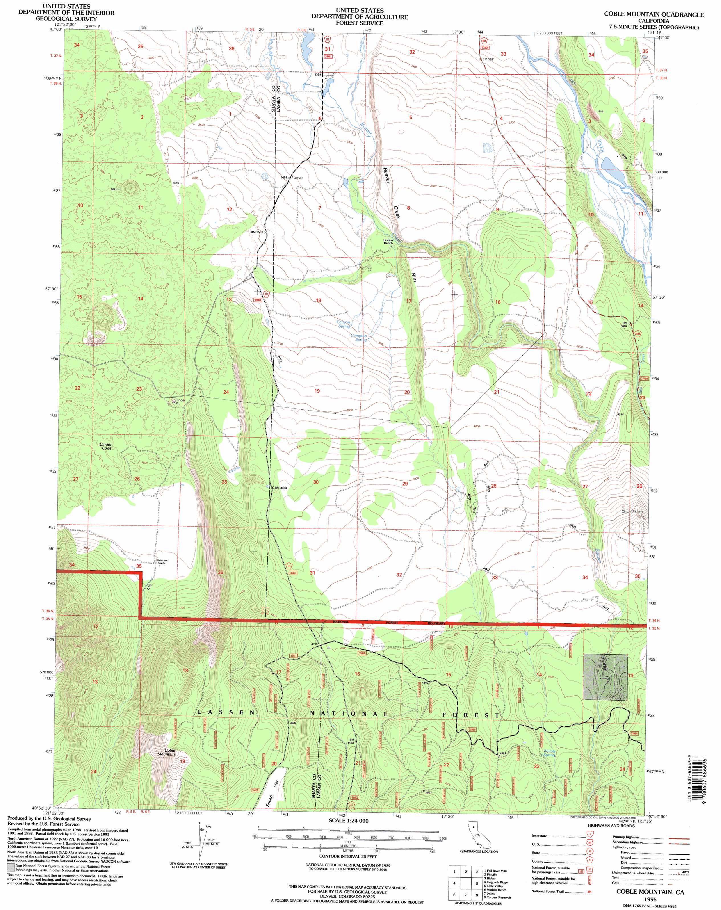
USGS Topo Quad 40121h3 - 1:24,000 scale
| Topo Map Name: | Coble Mountain |
| USGS Topo Quad ID: | 40121h3 |
| Print Size: | ca. 21 1/4" wide x 27" high |
| Southeast Coordinates: | 40.875° N latitude / 121.25° W longitude |
| Map Center Coordinates: | 40.9375° N latitude / 121.3125° W longitude |
| U.S. State: | CA |
| Filename: | o40121h3.jpg |
| Download Map JPG Image: | Coble Mountain topo map 1:24,000 scale |
| Map Type: | Topographic |
| Topo Series: | 7.5´ |
| Map Scale: | 1:24,000 |
| Source of Map Images: | United States Geological Survey (USGS) |
| Alternate Map Versions: |
Coble Mountain CA 1990, updated 1990 Download PDF Buy paper map Coble Mountain CA 1995, updated 1997 Download PDF Buy paper map Coble Mountain CA 2012 Download PDF Buy paper map Coble Mountain CA 2015 Download PDF Buy paper map |
| FStopo: | US Forest Service topo Coble Mountain is available: Download FStopo PDF Download FStopo TIF |
1:24,000 Topo Quads surrounding Coble Mountain
East Of Pondosa |
Timbered Crater |
Day |
Lookout |
Big Swamp |
Dana |
Fall River Mills |
Pittville |
Bieber |
Hog Valley |
Cassel |
Hogback Ridge |
Coble Mountain |
Little Valley |
Dixie Peak |
Burney Mountain East |
Murken Bench |
Jellico |
Corders Reservoir |
Straylor Lake |
Thousand Lakes Valley |
Old Station |
Swains Hole |
Poison Lake |
Harvey Mountain |
> Back to 40121e1 at 1:100,000 scale
> Back to 40120a1 at 1:250,000 scale
> Back to U.S. Topo Maps home
Coble Mountain topo map: Gazetteer
Coble Mountain: Cliffs
Beaver Creek Rim elevation 1159m 3802′Coble Mountain: Flats
Sheep Flat elevation 1438m 4717′Coble Mountain: Reservoirs
Mule Deer Flat Reservoir elevation 1308m 4291′Coble Mountain: Springs
Canyon Spring elevation 1097m 3599′Compton Spring elevation 1096m 3595′
Willow Spring elevation 1373m 4504′
Coble Mountain: Streams
Bob Creek elevation 1029m 3375′Coble Mountain: Summits
Cinder Cone elevation 1111m 3645′Coble Mountain elevation 1558m 5111′
Coble Mountain digital topo map on disk
Buy this Coble Mountain topo map showing relief, roads, GPS coordinates and other geographical features, as a high-resolution digital map file on DVD: