Hogback Ridge Topo Map California
To zoom in, hover over the map of Hogback Ridge
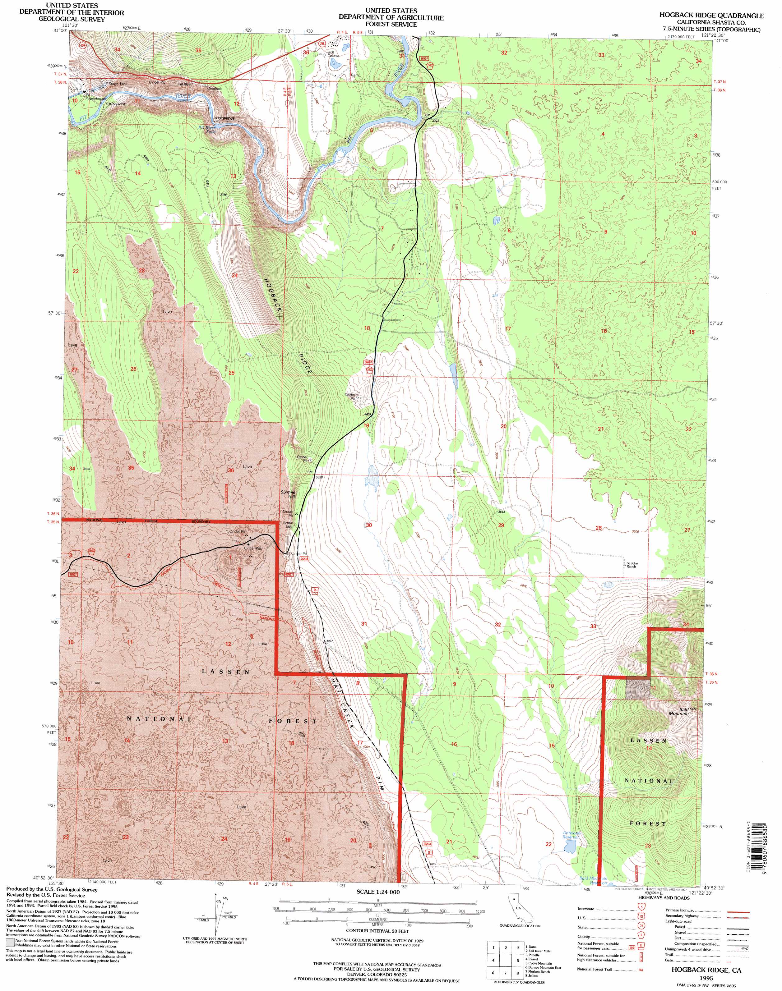
USGS Topo Quad 40121h4 - 1:24,000 scale
| Topo Map Name: | Hogback Ridge |
| USGS Topo Quad ID: | 40121h4 |
| Print Size: | ca. 21 1/4" wide x 27" high |
| Southeast Coordinates: | 40.875° N latitude / 121.375° W longitude |
| Map Center Coordinates: | 40.9375° N latitude / 121.4375° W longitude |
| U.S. State: | CA |
| Filename: | o40121h4.jpg |
| Download Map JPG Image: | Hogback Ridge topo map 1:24,000 scale |
| Map Type: | Topographic |
| Topo Series: | 7.5´ |
| Map Scale: | 1:24,000 |
| Source of Map Images: | United States Geological Survey (USGS) |
| Alternate Map Versions: |
Hogback Ridge CA 1990, updated 1990 Download PDF Buy paper map Hogback Ridge CA 1995, updated 1997 Download PDF Buy paper map Hogback Ridge CA 2012 Download PDF Buy paper map Hogback Ridge CA 2015 Download PDF Buy paper map |
| FStopo: | US Forest Service topo Hogback Ridge is available: Download FStopo PDF Download FStopo TIF |
1:24,000 Topo Quads surrounding Hogback Ridge
Pondosa |
East Of Pondosa |
Timbered Crater |
Day |
Lookout |
Burney Falls |
Dana |
Fall River Mills |
Pittville |
Bieber |
Burney |
Cassel |
Hogback Ridge |
Coble Mountain |
Little Valley |
Burney Mountain West |
Burney Mountain East |
Murken Bench |
Jellico |
Corders Reservoir |
Jacks Backbone |
Thousand Lakes Valley |
Old Station |
Swains Hole |
Poison Lake |
> Back to 40121e1 at 1:100,000 scale
> Back to 40120a1 at 1:250,000 scale
> Back to U.S. Topo Maps home
Hogback Ridge topo map: Gazetteer
Hogback Ridge: Dams
Antelope Reservoir Dam elevation 1236m 4055′Hogback Ridge: Falls
Pit River Falls elevation 925m 3034′Hogback Ridge: Reservoirs
Antelope Reservoir elevation 1236m 4055′Antelope Reservoir elevation 1216m 3989′
Hogback Ridge: Ridges
Hogback Ridge elevation 1280m 4199′Hogback Ridge: Summits
Bald Mountain elevation 1694m 5557′Sixmile Hill elevation 1198m 3930′
Hogback Ridge digital topo map on disk
Buy this Hogback Ridge topo map showing relief, roads, GPS coordinates and other geographical features, as a high-resolution digital map file on DVD: