Roaring Creek Topo Map California
To zoom in, hover over the map of Roaring Creek
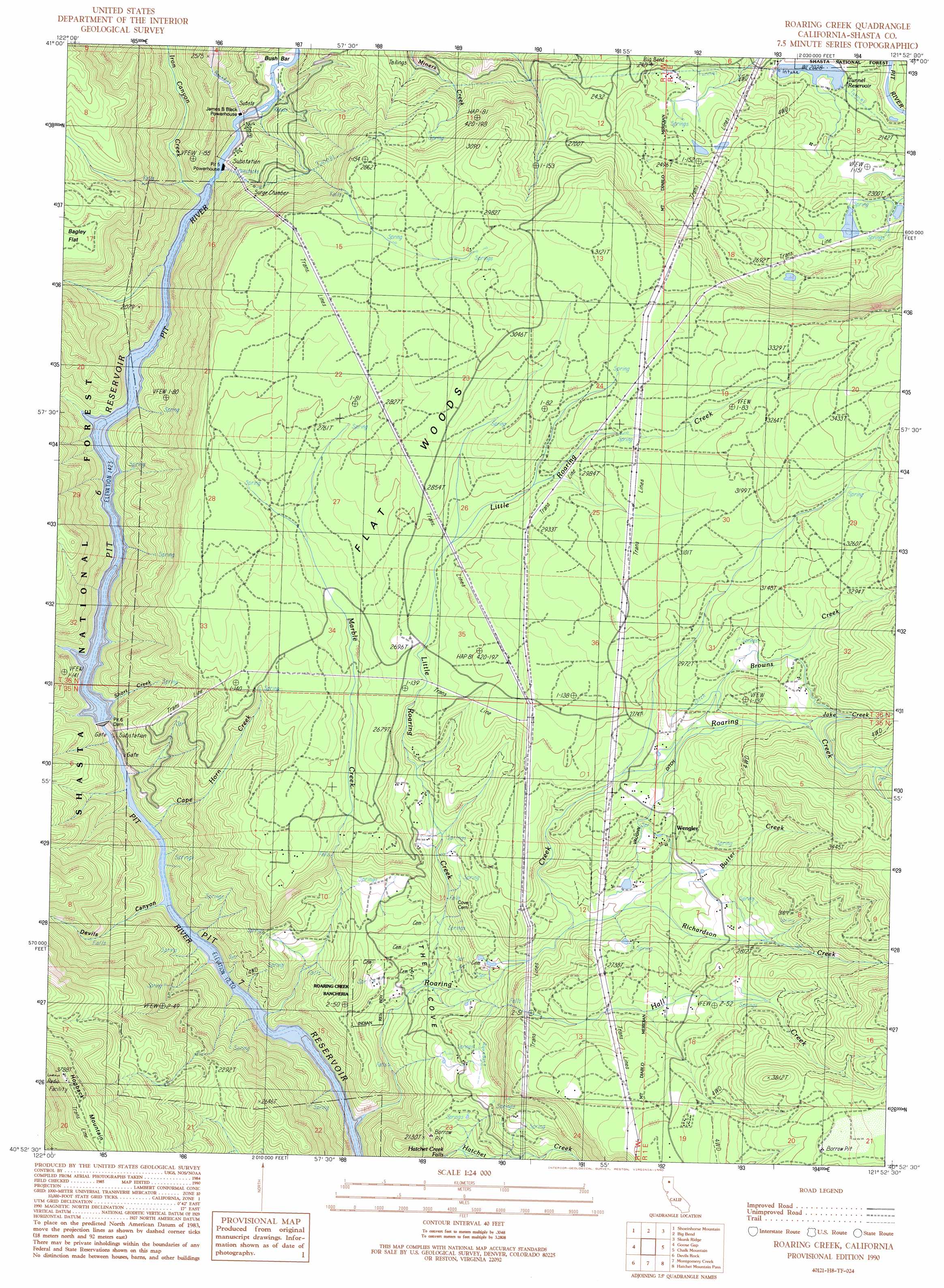
USGS Topo Quad 40121h8 - 1:24,000 scale
| Topo Map Name: | Roaring Creek |
| USGS Topo Quad ID: | 40121h8 |
| Print Size: | ca. 21 1/4" wide x 27" high |
| Southeast Coordinates: | 40.875° N latitude / 121.875° W longitude |
| Map Center Coordinates: | 40.9375° N latitude / 121.9375° W longitude |
| U.S. State: | CA |
| Filename: | o40121h8.jpg |
| Download Map JPG Image: | Roaring Creek topo map 1:24,000 scale |
| Map Type: | Topographic |
| Topo Series: | 7.5´ |
| Map Scale: | 1:24,000 |
| Source of Map Images: | United States Geological Survey (USGS) |
| Alternate Map Versions: |
Roaring Creek CA 1990, updated 1990 Download PDF Buy paper map Roaring Creek CA 1998, updated 2003 Download PDF Buy paper map Roaring Creek CA 2012 Download PDF Buy paper map Roaring Creek CA 2015 Download PDF Buy paper map |
| FStopo: | US Forest Service topo Roaring Creek is available: Download FStopo PDF Download FStopo TIF |
1:24,000 Topo Quads surrounding Roaring Creek
Girard Ridge |
Lake Mccloud |
Grizzly Peak |
Dead Horse Summit |
Pondosa |
Yellowjacket Mountain |
Shoeinhorse Mountain |
Big Bend |
Skunk Ridge |
Burney Falls |
Bollibokka Mountain |
Goose Gap |
Roaring Creek |
Chalk Mountain |
Burney |
Minnesota Mountain |
Devils Rock |
Montgomery Creek |
Hatchet Mountain Pass |
Burney Mountain West |
Bella Vista |
Oak Run |
Whitmore |
Miller Mountain |
Jacks Backbone |
> Back to 40121e1 at 1:100,000 scale
> Back to 40120a1 at 1:250,000 scale
> Back to U.S. Topo Maps home
Roaring Creek topo map: Gazetteer
Roaring Creek: Bars
Bush Barl elevation 443m 1453′Roaring Creek: Basins
The Cove elevation 542m 1778′Roaring Creek: Dams
Pit 5 Conduit Embankment 97-108 Dam elevation 619m 2030′Pit Six Dam elevation 411m 1348′
Roaring Creek: Falls
Hatchet Creek Falls elevation 494m 1620′Roaring Creek: Populated Places
Wengler elevation 815m 2673′Roaring Creek: Reservoirs
Pit Six Reservoir elevation 411m 1348′Tunnel Reservoir elevation 619m 2030′
Roaring Creek: Streams
Browns Creek elevation 837m 2746′Butter Creek elevation 761m 2496′
Cape Horn Creek elevation 389m 1276′
Hall Creek elevation 625m 2050′
Iron Canyon Creek elevation 435m 1427′
Jake Creek elevation 912m 2992′
Little Roaring Creek elevation 388m 1272′
Marble Creek elevation 388m 1272′
Richardson Creek elevation 713m 2339′
Roaring Creek elevation 526m 1725′
Short Creek elevation 435m 1427′
Roaring Creek: Summits
Hogback Mountain elevation 1128m 3700′Roaring Creek: Valleys
Devils Canyon elevation 393m 1289′Iron Canyon elevation 459m 1505′
Roaring Creek: Woods
Flat Woods elevation 839m 2752′Roaring Creek digital topo map on disk
Buy this Roaring Creek topo map showing relief, roads, GPS coordinates and other geographical features, as a high-resolution digital map file on DVD: