Los Molinos Topo Map California
To zoom in, hover over the map of Los Molinos
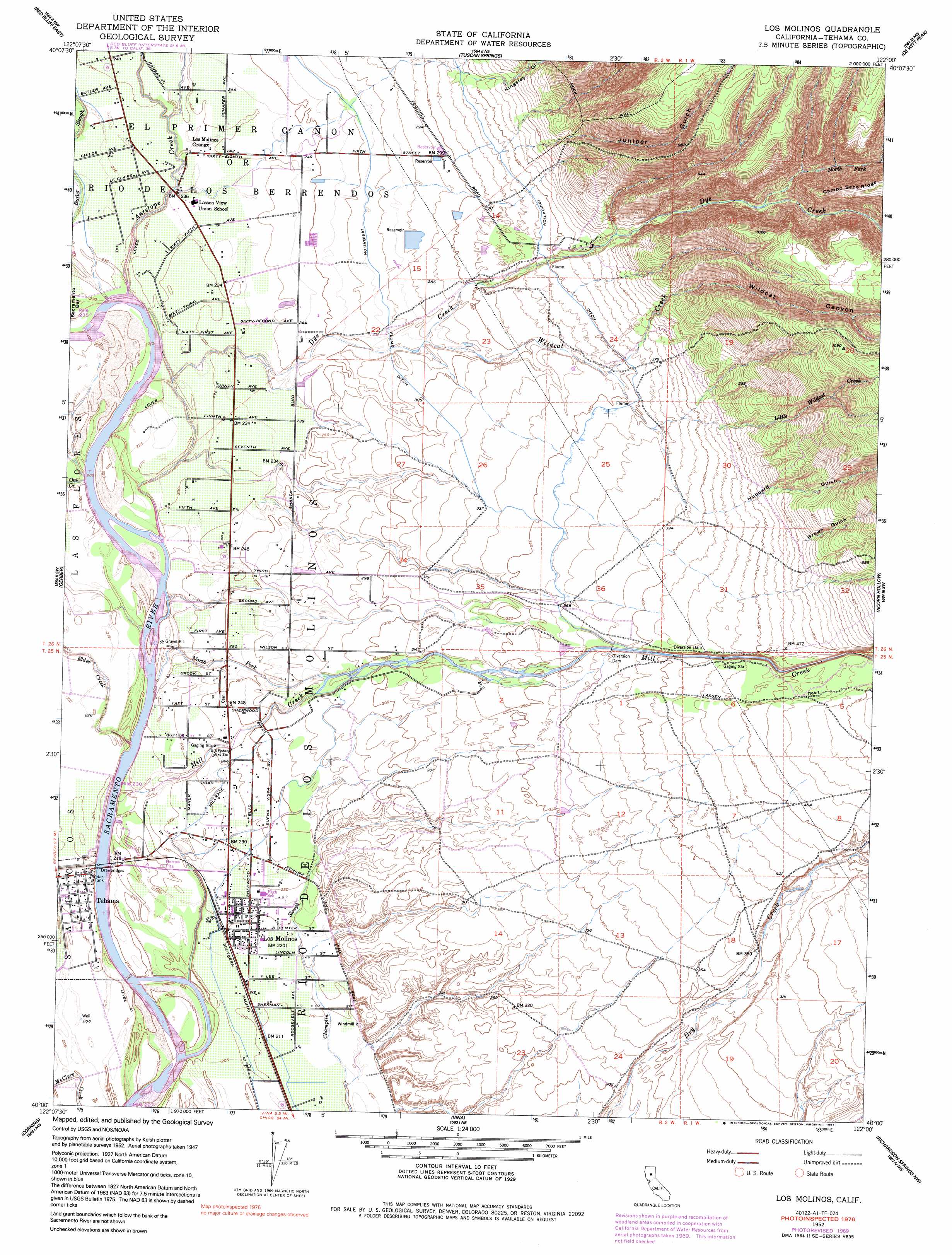
USGS Topo Quad 40122a1 - 1:24,000 scale
| Topo Map Name: | Los Molinos |
| USGS Topo Quad ID: | 40122a1 |
| Print Size: | ca. 21 1/4" wide x 27" high |
| Southeast Coordinates: | 40° N latitude / 122° W longitude |
| Map Center Coordinates: | 40.0625° N latitude / 122.0625° W longitude |
| U.S. State: | CA |
| Filename: | o40122a1.jpg |
| Download Map JPG Image: | Los Molinos topo map 1:24,000 scale |
| Map Type: | Topographic |
| Topo Series: | 7.5´ |
| Map Scale: | 1:24,000 |
| Source of Map Images: | United States Geological Survey (USGS) |
| Alternate Map Versions: |
Los Molinos CA 1952, updated 1953 Download PDF Buy paper map Los Molinos CA 1952, updated 1971 Download PDF Buy paper map Los Molinos CA 1952, updated 1985 Download PDF Buy paper map Los Molinos CA 1952, updated 1991 Download PDF Buy paper map Los Molinos CA 2012 Download PDF Buy paper map Los Molinos CA 2015 Download PDF Buy paper map |
1:24,000 Topo Quads surrounding Los Molinos
Hooker |
Bend |
Dales |
Inskip Hill |
Finley Butte |
Red Bluff West |
Red Bluff East |
Tuscan Springs |
Dewitt Peak |
Panther Spring |
West Of Gerber |
Gerber |
Los Molinos |
Acorn Hollow |
Ishi Caves |
Henleyville |
Corning |
Vina |
Richardson Springs Nw |
Campbell Mound |
Black Butte Dam |
Kirkwood |
Foster Island |
Nord |
Richardson Springs |
> Back to 40122a1 at 1:100,000 scale
> Back to 40122a1 at 1:250,000 scale
> Back to U.S. Topo Maps home
Los Molinos topo map: Gazetteer
Los Molinos: Parks
Halbert Park elevation 65m 213′Mill Creek Park elevation 65m 213′
Los Molinos: Populated Places
Los Molinos elevation 68m 223′Tehama elevation 64m 209′
Los Molinos: Post Offices
Los Molinos Post Office elevation 69m 226′Tehama Post Office elevation 63m 206′
Los Molinos: Streams
Antelope Creek elevation 65m 213′Dye Creek elevation 64m 209′
Elder Creek elevation 63m 206′
Little Wildcat Creek elevation 102m 334′
Mill Creek elevation 59m 193′
North Fork Dye Creek elevation 147m 482′
North Fork Mill Creek elevation 60m 196′
Oat Creek elevation 65m 213′
Wildcat Creek elevation 81m 265′
Los Molinos: Valleys
Brown Gulch elevation 151m 495′Hubbard Gulch elevation 114m 374′
Juniper Gulch elevation 104m 341′
Kingsley Gulch elevation 104m 341′
Wildcat Canyon elevation 101m 331′
Los Molinos digital topo map on disk
Buy this Los Molinos topo map showing relief, roads, GPS coordinates and other geographical features, as a high-resolution digital map file on DVD: