South Yolla Bolly Mountains Topo Map California
To zoom in, hover over the map of South Yolla Bolly Mountains
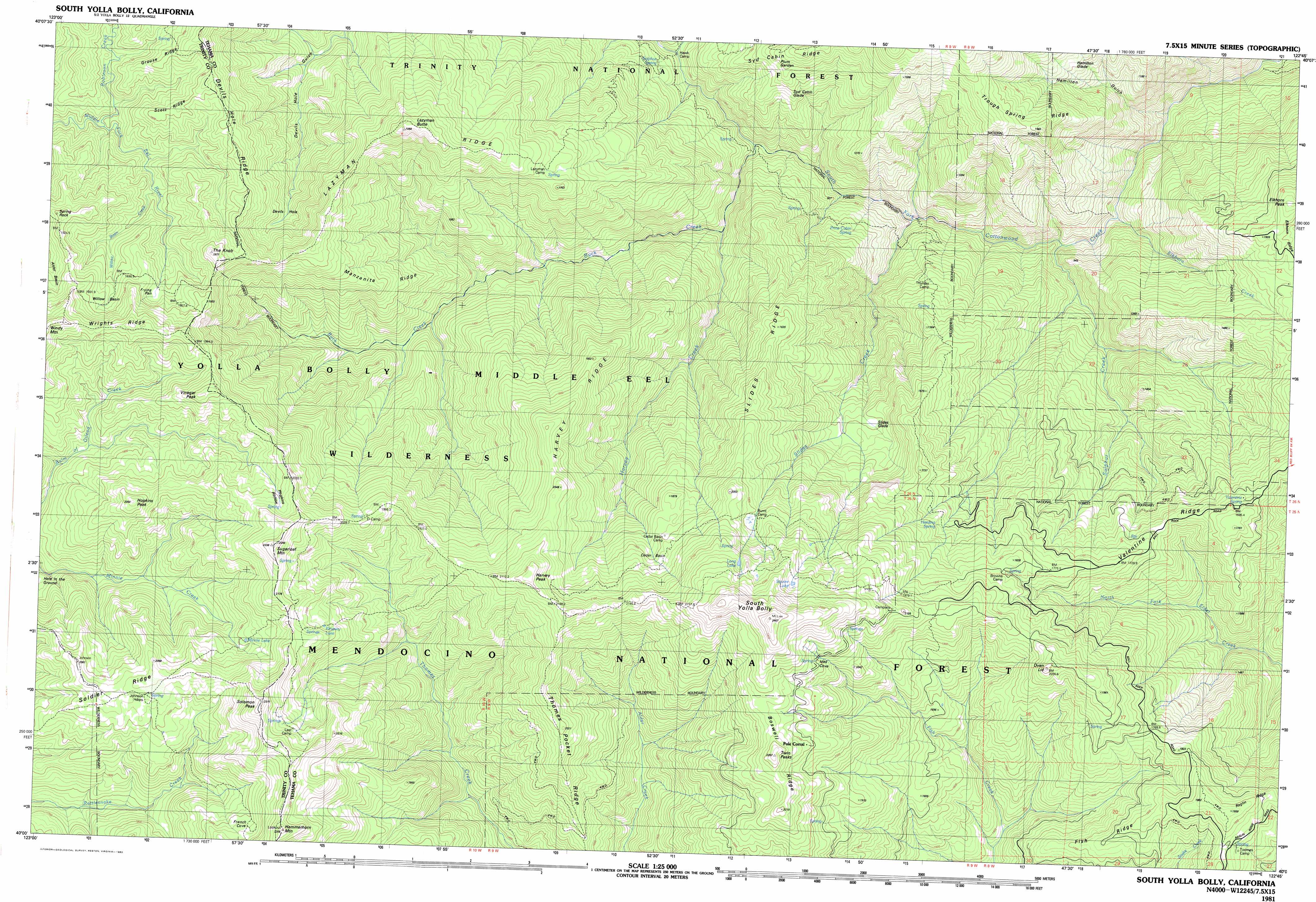
USGS Topo Quad 40122a7 - 1:25,000 scale
| Topo Map Name: | South Yolla Bolly Mountains |
| USGS Topo Quad ID: | 40122a7 |
| Print Size: | ca. 39" wide x 24" high |
| Southeast Coordinates: | 40° N latitude / 122.75° W longitude |
| Map Center Coordinates: | 40.0625° N latitude / 122.875° W longitude |
| U.S. State: | CA |
| Filename: | k40122a7.jpg |
| Download Map JPG Image: | South Yolla Bolly Mountains topo map 1:25,000 scale |
| Map Type: | Topographic |
| Topo Series: | 7.5´x15´ |
| Map Scale: | 1:25,000 |
| Source of Map Images: | United States Geological Survey (USGS) |
| Alternate Map Versions: |
South Yolla Bolly CA 1981, updated 1982 Download PDF Buy paper map |
| FStopo: | US Forest Service topo South Yolla Bolly Mountains is available: Download FStopo PDF Download FStopo TIF |
1:24,000 Topo Quads surrounding South Yolla Bolly Mountains
Pony Buck Peak |
Beegum |
Rosewood |
||
Black Rock Mountain |
Tomhead Mountain |
Cold Fork |
Oxbow Bridge |
|
Wrights Ridge |
South Yolla Bolly Mountains |
Raglin Ridge |
Lowrey |
|
Leech Lake Mountain |
Buck Rock |
Ball Mountain |
Riley Ridge |
Paskenta |
Newhouse Ridge |
Mendocino Pass |
Log Spring |
Hall Ridge |
Newville |
> Back to 40122a1 at 1:100,000 scale
> Back to 40122a1 at 1:250,000 scale
> Back to U.S. Topo Maps home
South Yolla Bolly Mountains topo map: Gazetteer
South Yolla Bolly Mountains: Areas
Plum Garden elevation 1353m 4438′South Yolla Bolly Mountains: Basins
Cedar Basin elevation 1959m 6427′Devils Hole elevation 1561m 5121′
Frying Pan elevation 1825m 5987′
Willow Basin elevation 1926m 6318′
South Yolla Bolly Mountains: Flats
Hamilton Glade elevation 1126m 3694′Hole-in-the-Ground elevation 1699m 5574′
Slides Glade elevation 1367m 4484′
Syd Cabin Glade elevation 1239m 4064′
South Yolla Bolly Mountains: Lakes
Kingsley Lake elevation 1968m 6456′Long Lake elevation 2156m 7073′
Minnie Lake elevation 1911m 6269′
Square Lake elevation 2140m 7020′
South Yolla Bolly Mountains: Pillars
Spring Rock elevation 1925m 6315′South Yolla Bolly Mountains: Ridges
Devils Hole Ridge elevation 1845m 6053′Fish Ridge elevation 1757m 5764′
Grouse Ridge elevation 1806m 5925′
Harvey Ridge elevation 1894m 6213′
Lazyman Ridge elevation 1924m 6312′
Manzanita Ridge elevation 1615m 5298′
Scott Ridge elevation 1826m 5990′
Slides Ridge elevation 1641m 5383′
Thomes Pocket Ridge elevation 1973m 6473′
Trough Spring Ridge elevation 1525m 5003′
Valentine Ridge elevation 1669m 5475′
South Yolla Bolly Mountains: Springs
Harding Spring elevation 1660m 5446′Lazyman Spring elevation 1635m 5364′
Sulphur Spring elevation 1075m 3526′
Valentine Spring elevation 1665m 5462′
South Yolla Bolly Mountains: Streams
Buck Creek elevation 898m 2946′Elkhorn Creek elevation 741m 2431′
Harvey Creek elevation 958m 3143′
Robinson Creek elevation 1583m 5193′
Slides Creek elevation 800m 2624′
Sulphur Creek elevation 756m 2480′
Willow Basin Creek elevation 1650m 5413′
South Yolla Bolly Mountains: Summits
Elkhorn Peak elevation 1583m 5193′Hammerhorn Mountain elevation 2299m 7542′
Harvey Peak elevation 2221m 7286′
Hopkins Peak elevation 2054m 6738′
Lazyman Butte elevation 1965m 6446′
Linn Mount elevation 2184m 7165′
Mount Linn elevation 2417m 7929′
Oven Lid elevation 2021m 6630′
Solomon Peak elevation 2306m 7565′
South Yolla Bolly elevation 2229m 7312′
South Yolla Bolly Mountains elevation 2452m 8044′
Sugarloaf Mountain elevation 2244m 7362′
The Knob elevation 1965m 6446′
Twin Peaks elevation 2247m 7372′
Vinegar Peak elevation 1995m 6545′
South Yolla Bolly Mountains: Trails
Devils Hole Ridge Trail elevation 1801m 5908′French Trail elevation 1896m 6220′
Ides Cove National Recreation Trail elevation 2085m 6840′
Lazyman Butte Trail elevation 1865m 6118′
Soldier Trail elevation 2075m 6807′
South Yolla Bolly Mountains: Valleys
French Cove elevation 1771m 5810′Hamilton Gulch elevation 706m 2316′
Hopkins Hollow elevation 1882m 6174′
South Yolla Bolly Mountains digital topo map on disk
Buy this South Yolla Bolly Mountains topo map showing relief, roads, GPS coordinates and other geographical features, as a high-resolution digital map file on DVD: