Tuscan Springs Topo Map California
To zoom in, hover over the map of Tuscan Springs
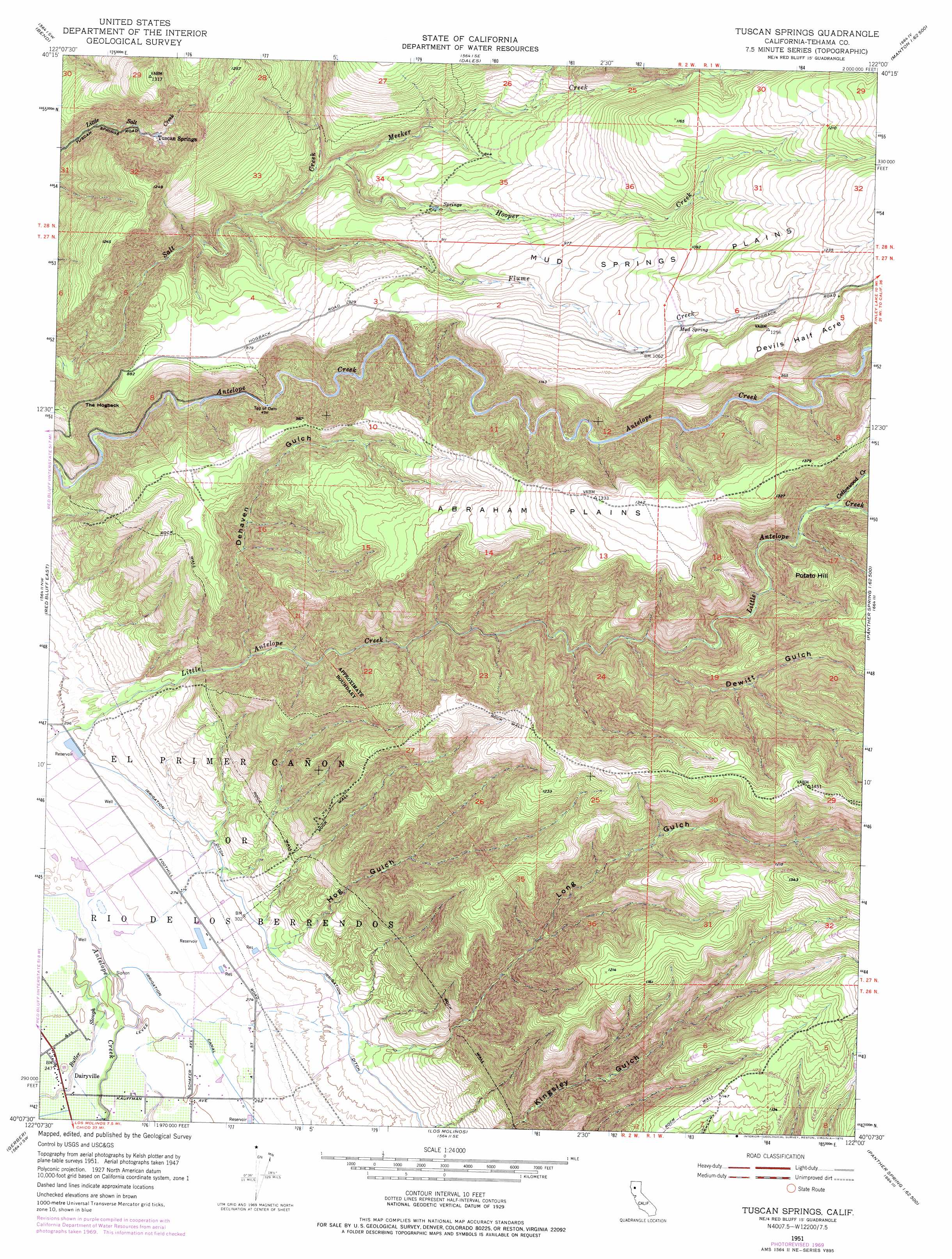
USGS Topo Quad 40122b1 - 1:24,000 scale
| Topo Map Name: | Tuscan Springs |
| USGS Topo Quad ID: | 40122b1 |
| Print Size: | ca. 21 1/4" wide x 27" high |
| Southeast Coordinates: | 40.125° N latitude / 122° W longitude |
| Map Center Coordinates: | 40.1875° N latitude / 122.0625° W longitude |
| U.S. State: | CA |
| Filename: | o40122b1.jpg |
| Download Map JPG Image: | Tuscan Springs topo map 1:24,000 scale |
| Map Type: | Topographic |
| Topo Series: | 7.5´ |
| Map Scale: | 1:24,000 |
| Source of Map Images: | United States Geological Survey (USGS) |
| Alternate Map Versions: |
Tuscan Springs CA 1951, updated 1953 Download PDF Buy paper map Tuscan Springs CA 1951, updated 1970 Download PDF Buy paper map Tuscan Springs CA 1951, updated 1975 Download PDF Buy paper map Tuscan Springs CA 2012 Download PDF Buy paper map Tuscan Springs CA 2015 Download PDF Buy paper map |
1:24,000 Topo Quads surrounding Tuscan Springs
Cottonwood |
Balls Ferry |
Tuscan Buttes Ne |
Shingletown |
Manton |
Hooker |
Bend |
Dales |
Inskip Hill |
Finley Butte |
Red Bluff West |
Red Bluff East |
Tuscan Springs |
Dewitt Peak |
Panther Spring |
West Of Gerber |
Gerber |
Los Molinos |
Acorn Hollow |
Ishi Caves |
Henleyville |
Corning |
Vina |
Richardson Springs Nw |
Campbell Mound |
> Back to 40122a1 at 1:100,000 scale
> Back to 40122a1 at 1:250,000 scale
> Back to U.S. Topo Maps home
Tuscan Springs topo map: Gazetteer
Tuscan Springs: Lakes
Norvell Pond elevation 347m 1138′Tuscan Springs: Plains
Abraham Plains elevation 381m 1250′Devils Half Acre elevation 395m 1295′
Mud Springs Plains elevation 348m 1141′
Tuscan Springs: Populated Places
Dairyville elevation 75m 246′Tuscan Springs: Ridges
The Hogback elevation 228m 748′Tuscan Springs: Springs
Mud Spring elevation 333m 1092′Tuscan Springs elevation 230m 754′
Tuscan Springs: Streams
Cottonwood Creek elevation 258m 846′Flume Creek elevation 191m 626′
Hooper Creek elevation 220m 721′
Meeker Creek elevation 200m 656′
Tuscan Springs: Summits
Potato Hill elevation 372m 1220′Tuscan Springs: Valleys
Dehaven Gulch elevation 127m 416′Dewitt Gulch elevation 225m 738′
Hog Gulch elevation 98m 321′
Long Gulch elevation 101m 331′
Tuscan Springs digital topo map on disk
Buy this Tuscan Springs topo map showing relief, roads, GPS coordinates and other geographical features, as a high-resolution digital map file on DVD: