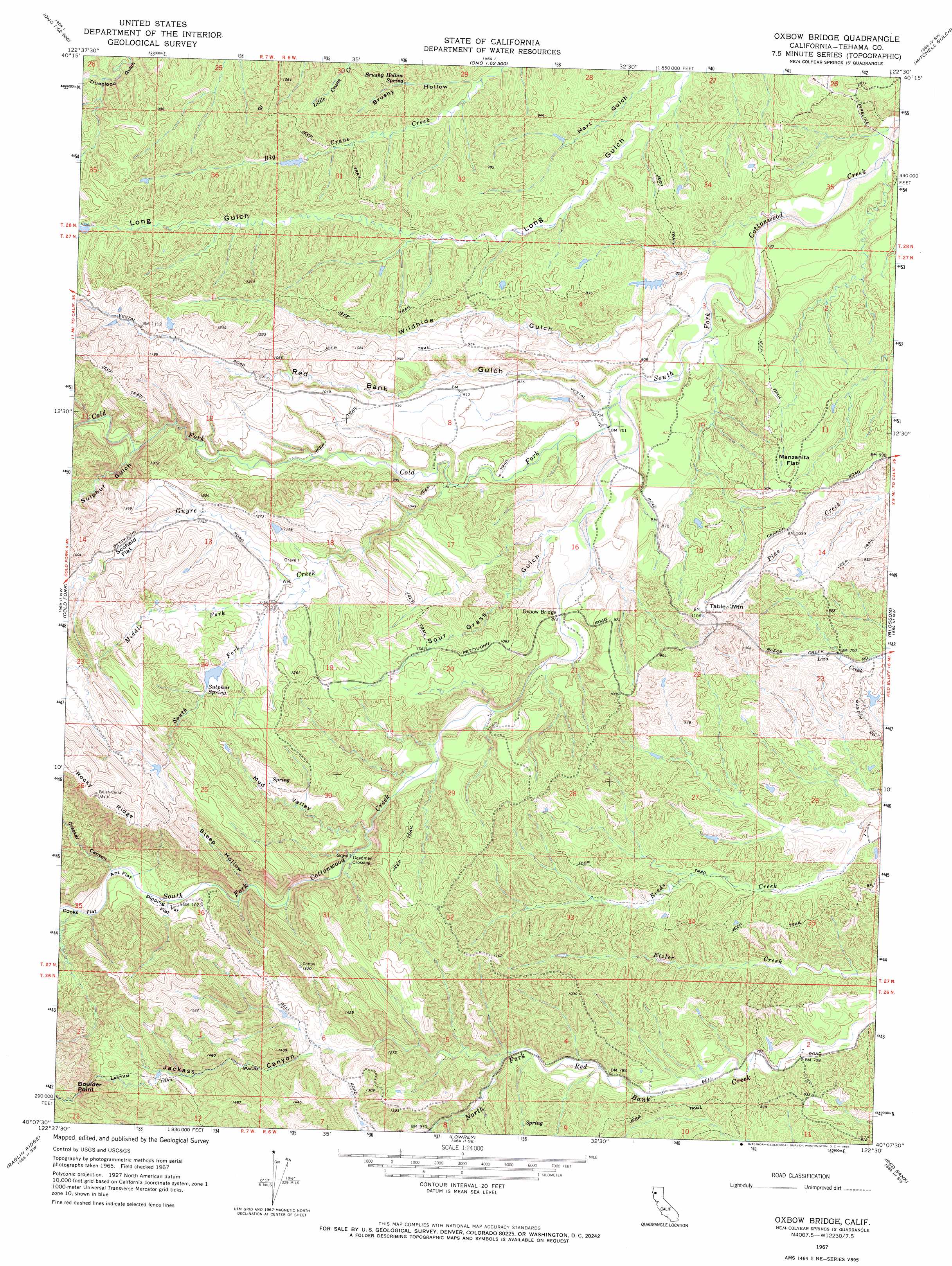
Oxbow Bridge Topo Map California
To zoom in, hover over the map of Oxbow Bridge
USGS Topo Quad 40122b5 - 1:24,000 scale
| Topo Map Name: | Oxbow Bridge |
| USGS Topo Quad ID: | 40122b5 |
| Print Size: | ca. 21 1/4" wide x 27" high |
| Southeast Coordinates: | 40.125° N latitude / 122.5° W longitude |
| Map Center Coordinates: | 40.1875° N latitude / 122.5625° W longitude |
| U.S. State: | CA |
| Filename: | o40122b5.jpg |
| Download Map JPG Image: | Oxbow Bridge topo map 1:24,000 scale |
| Map Type: | Topographic |
| Topo Series: | 7.5´ |
| Map Scale: | 1:24,000 |
| Source of Map Images: | United States Geological Survey (USGS) |
| Alternate Map Versions: |
Oxbow Bridge CA 1967, updated 1968 Download PDF Buy paper map Oxbow Bridge CA 1967, updated 1968 Download PDF Buy paper map Oxbow Bridge CA 2012 Download PDF Buy paper map Oxbow Bridge CA 2015 Download PDF Buy paper map |
1:24,000 Topo Quads surrounding Oxbow Bridge
Arbuckle Mountain |
Ono |
Olinda |
Cottonwood |
|
Beegum |
Rosewood |
Mitchell Gulch |
Hooker |
|
Tomhead Mountain |
Cold Fork |
Oxbow Bridge |
Blossom |
Red Bluff West |
South Yolla Bolly Mountains |
Raglin Ridge |
Lowrey |
Red Bank |
West Of Gerber |
Ball Mountain |
Riley Ridge |
Paskenta |
Flournoy |
Henleyville |
> Back to 40122a1 at 1:100,000 scale
> Back to 40122a1 at 1:250,000 scale
> Back to U.S. Topo Maps home
Oxbow Bridge topo map: Gazetteer
Oxbow Bridge: Bridges
Oxbow Bridge elevation 240m 787′Oxbow Bridge: Capes
Boulder Point elevation 442m 1450′Oxbow Bridge: Crossings
Deadman Crossing elevation 272m 892′Oxbow Bridge: Flats
Ant Flat elevation 312m 1023′Dipping Vat Flat elevation 306m 1003′
Manzanita Flat elevation 302m 990′
Scofield Flat elevation 359m 1177′
Oxbow Bridge: Populated Places
Fowler Place elevation 238m 780′Gilliam Place elevation 320m 1049′
Hatfield Place (historical) elevation 250m 820′
Hercraff Place elevation 228m 748′
Irish Place (historical) elevation 239m 784′
McCartney Place elevation 253m 830′
Pete Hoff Place elevation 326m 1069′
Swain Place elevation 340m 1115′
Walker Place (historical) elevation 230m 754′
Oxbow Bridge: Springs
Brushy Hollow Spring elevation 268m 879′Sulphur Spring elevation 362m 1187′
Oxbow Bridge: Streams
Cold Fork elevation 226m 741′Guyre Creek elevation 247m 810′
Middle Fork Guyre Creek elevation 331m 1085′
South Fork Guyre Creek elevation 336m 1102′
Oxbow Bridge: Summits
Table Mountain elevation 340m 1115′Oxbow Bridge: Valleys
Brushy Hollow elevation 245m 803′Cracker Canyon elevation 313m 1026′
Jackass Canyon elevation 313m 1026′
Mud Valley elevation 282m 925′
Red Bank Gulch elevation 230m 754′
Sour Grass Gulch elevation 246m 807′
Steep Hollow elevation 327m 1072′
Sulphur Gulch elevation 292m 958′
Wildhide Gulch elevation 224m 734′
Oxbow Bridge digital topo map on disk
Buy this Oxbow Bridge topo map showing relief, roads, GPS coordinates and other geographical features, as a high-resolution digital map file on DVD: