Tomhead Mountain Topo Map California
To zoom in, hover over the map of Tomhead Mountain
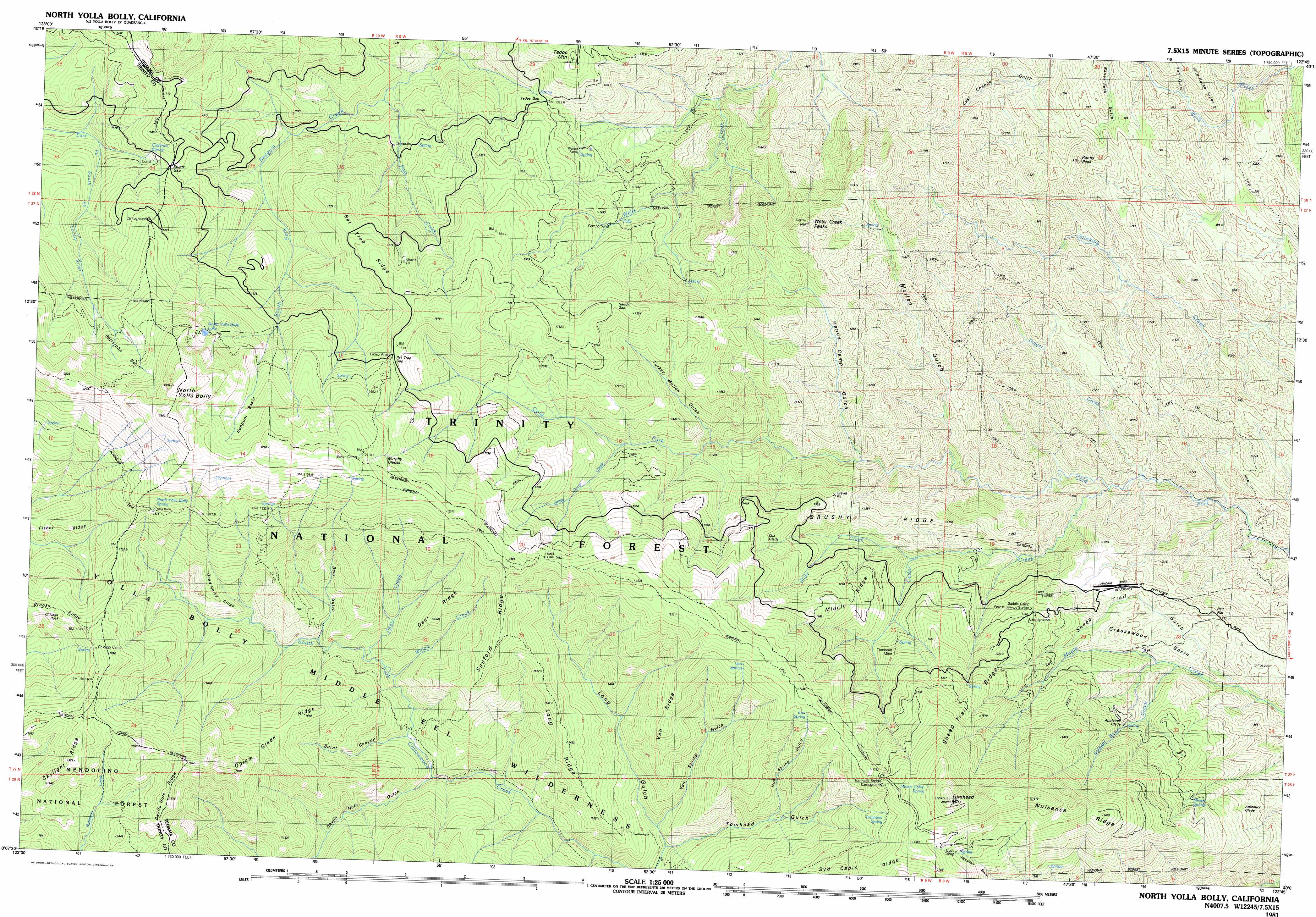
USGS Topo Quad 40122b7 - 1:25,000 scale
| Topo Map Name: | Tomhead Mountain |
| USGS Topo Quad ID: | 40122b7 |
| Print Size: | ca. 39" wide x 24" high |
| Southeast Coordinates: | 40.125° N latitude / 122.75° W longitude |
| Map Center Coordinates: | 40.1875° N latitude / 122.875° W longitude |
| U.S. State: | CA |
| Filename: | k40122b7.jpg |
| Download Map JPG Image: | Tomhead Mountain topo map 1:25,000 scale |
| Map Type: | Topographic |
| Topo Series: | 7.5´x15´ |
| Map Scale: | 1:25,000 |
| Source of Map Images: | United States Geological Survey (USGS) |
| Alternate Map Versions: |
North Yolla Bolly CA 1981, updated 1981 Download PDF Buy paper map |
| FStopo: | US Forest Service topo Tomhead Mountain is available: Download FStopo PDF Download FStopo TIF |
1:24,000 Topo Quads surrounding Tomhead Mountain
Wildwood |
Arbuckle Mountain |
Ono |
||
Pony Buck Peak |
Beegum |
Rosewood |
||
Black Rock Mountain |
Tomhead Mountain |
Cold Fork |
Oxbow Bridge |
|
Wrights Ridge |
South Yolla Bolly Mountains |
Raglin Ridge |
Lowrey |
|
Leech Lake Mountain |
Buck Rock |
Ball Mountain |
Riley Ridge |
Paskenta |
> Back to 40122a1 at 1:100,000 scale
> Back to 40122a1 at 1:250,000 scale
> Back to U.S. Topo Maps home
Tomhead Mountain topo map: Gazetteer
Tomhead Mountain: Basins
Beegum Basin elevation 2011m 6597′Cedar Basin elevation 1892m 6207′
Greasewood Basin elevation 896m 2939′
Pettijohn Basin elevation 1937m 6354′
Tomhead Mountain: Flats
Appletree Glade elevation 1144m 3753′Attlebury Glade elevation 1089m 3572′
Cox Glade elevation 1449m 4753′
Murphy Glades elevation 1994m 6541′
Red Flat elevation 924m 3031′
Tomhead Mountain: Gaps
East Low Gap elevation 1779m 5836′Rat Trap Gap elevation 1814m 5951′
Stuart Gap elevation 1522m 4993′
Tedoc Gap elevation 1374m 4507′
Tomhead Mountain: Lakes
North Yolla Bolly Lake elevation 1997m 6551′Tomhead Mountain: Mines
Tomhead Mine elevation 1229m 4032′Tomhead Mountain: Pillars
Chicago Rock elevation 1617m 5305′Tomhead Mountain: Ridges
Brushy Ridge elevation 1343m 4406′Dead Horse Ridge elevation 1546m 5072′
Deer Ridge elevation 1517m 4977′
Fisher Ridge elevation 1570m 5150′
Iron Spring Ridge elevation 1543m 5062′
Iron Spring Ridge elevation 1515m 4970′
Long Ridge elevation 1886m 6187′
Middle Ridge elevation 1360m 4461′
Nuisance Ridge elevation 2038m 6686′
Opium Glade Ridge elevation 1599m 5246′
Rat Trap Ridge elevation 1734m 5688′
Sanford Ridge elevation 1885m 6184′
Sheep Trail Ridge elevation 1508m 4947′
Syd Cabin Ridge elevation 1516m 4973′
Syd Cabin Ridge elevation 1776m 5826′
Van Ridge elevation 1566m 5137′
Tomhead Mountain: Springs
Chicago Spring elevation 1788m 5866′Clarence Spring elevation 1538m 5045′
Iron Spring elevation 1654m 5426′
Lone Pine Spring elevation 1187m 3894′
Lone Pine Springs elevation 1080m 3543′
Miners Cabin Spring elevation 1875m 6151′
Miners Spring elevation 1136m 3727′
North Yolla Bolly Spring elevation 1889m 6197′
North Yolla Bolly Spring elevation 1898m 6227′
Stinking Springs elevation 453m 1486′
Tomhead Spring elevation 1638m 5374′
Van Spring elevation 1686m 5531′
Tomhead Mountain: Streams
Cedar Creek elevation 623m 2043′Deer Creek elevation 1224m 4015′
Digger Creek elevation 586m 1922′
Jones Camp Creek elevation 1321m 4333′
Post Creek elevation 1086m 3562′
Slide Creek elevation 965m 3166′
Switzel-Baum Creek elevation 806m 2644′
Willow Creek elevation 1168m 3832′
Tomhead Mountain: Summits
North Yolla Bolly Mountains elevation 2381m 7811′Raney Peak elevation 844m 2769′
Tedoc Mountain elevation 1563m 5127′
Tomhead Mountain elevation 2019m 6624′
Wells Creek Peak elevation 1476m 4842′
Tomhead Mountain: Trails
Long Ridge Trail elevation 1487m 4878′North Yolla Bolly Cold Fork Trail elevation 2203m 7227′
Pettijohn Trail elevation 1726m 5662′
South Fork Cottonwood Trail elevation 1022m 3353′
Tomhead Mountain: Valleys
Bear Gulch elevation 1270m 4166′Bear Gulch elevation 843m 2765′
Burnt Canyon elevation 1164m 3818′
Devils Hole Gulch elevation 1136m 3727′
Handy Camp Gulch elevation 1086m 3562′
Hog Gulch elevation 480m 1574′
Iron Spring Gulch elevation 1205m 3953′
Long Gulch elevation 1078m 3536′
Mullen Gulch elevation 812m 2664′
Sheep Trail Gulch elevation 743m 2437′
Tomhead Gulch elevation 977m 3205′
Turkey Mullen Gulch elevation 1255m 4117′
Van Spring Gulch elevation 1075m 3526′
Tomhead Mountain digital topo map on disk
Buy this Tomhead Mountain topo map showing relief, roads, GPS coordinates and other geographical features, as a high-resolution digital map file on DVD: