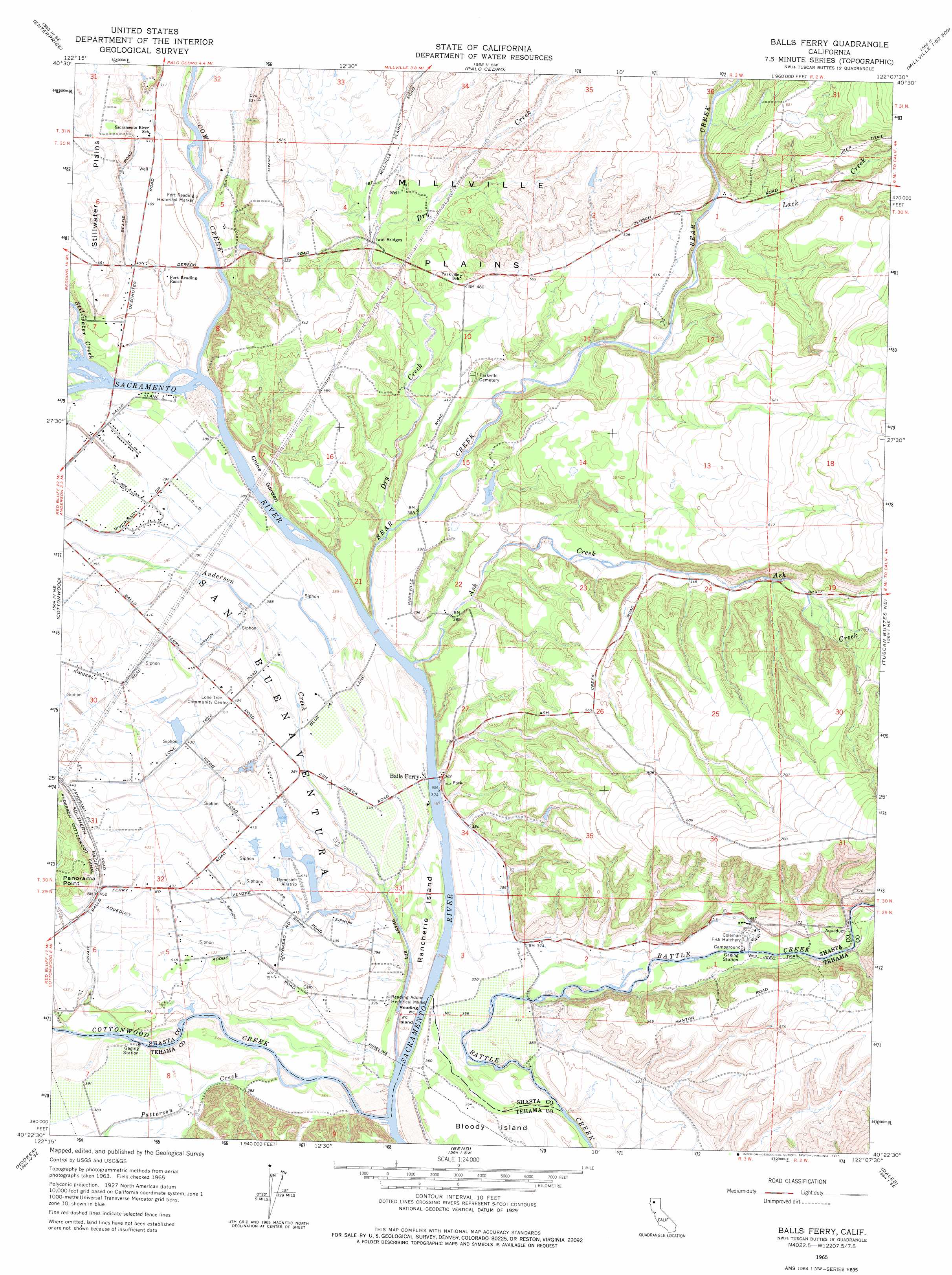
Balls Ferry Topo Map California
To zoom in, hover over the map of Balls Ferry
USGS Topo Quad 40122d2 - 1:24,000 scale
| Topo Map Name: | Balls Ferry |
| USGS Topo Quad ID: | 40122d2 |
| Print Size: | ca. 21 1/4" wide x 27" high |
| Southeast Coordinates: | 40.375° N latitude / 122.125° W longitude |
| Map Center Coordinates: | 40.4375° N latitude / 122.1875° W longitude |
| U.S. State: | CA |
| Filename: | o40122d2.jpg |
| Download Map JPG Image: | Balls Ferry topo map 1:24,000 scale |
| Map Type: | Topographic |
| Topo Series: | 7.5´ |
| Map Scale: | 1:24,000 |
| Source of Map Images: | United States Geological Survey (USGS) |
| Alternate Map Versions: |
Balls Ferry CA 1965, updated 1966 Download PDF Buy paper map Balls Ferry CA 1965, updated 1966 Download PDF Buy paper map Balls Ferry CA 1965, updated 1975 Download PDF Buy paper map Balls Ferry CA 2012 Download PDF Buy paper map Balls Ferry CA 2015 Download PDF Buy paper map |
1:24,000 Topo Quads surrounding Balls Ferry
Shasta Dam |
Project City |
Bella Vista |
Oak Run |
Whitmore |
Redding |
Enterprise |
Palo Cedro |
Clough Gulch |
Inwood |
Olinda |
Cottonwood |
Balls Ferry |
Tuscan Buttes Ne |
Shingletown |
Mitchell Gulch |
Hooker |
Bend |
Dales |
Inskip Hill |
Blossom |
Red Bluff West |
Red Bluff East |
Tuscan Springs |
Dewitt Peak |
> Back to 40122a1 at 1:100,000 scale
> Back to 40122a1 at 1:250,000 scale
> Back to U.S. Topo Maps home
Balls Ferry topo map: Gazetteer
Balls Ferry: Bridges
Balls Ferry Bridge elevation 109m 357′Twin Bridges elevation 138m 452′
Balls Ferry: Capes
Panorama Point elevation 162m 531′Balls Ferry: Flats
China Garden elevation 117m 383′Balls Ferry: Islands
Rancherie Island elevation 111m 364′Reading Island elevation 112m 367′
Balls Ferry: Parks
Reading Adobe Historical Marker elevation 119m 390′Balls Ferry: Populated Places
Balls Ferry Fishing Resort elevation 114m 374′Balls Ferry: Streams
Anderson Creek elevation 106m 347′Ash Creek elevation 110m 360′
Bear Creek elevation 111m 364′
Cottonwood Creek elevation 104m 341′
Cow Creek elevation 114m 374′
Dry Creek elevation 112m 367′
Lack Creek elevation 143m 469′
Patterson Creek elevation 113m 370′
Stillwater Creek elevation 115m 377′
Balls Ferry digital topo map on disk
Buy this Balls Ferry topo map showing relief, roads, GPS coordinates and other geographical features, as a high-resolution digital map file on DVD: