Oak Run Topo Map California
To zoom in, hover over the map of Oak Run
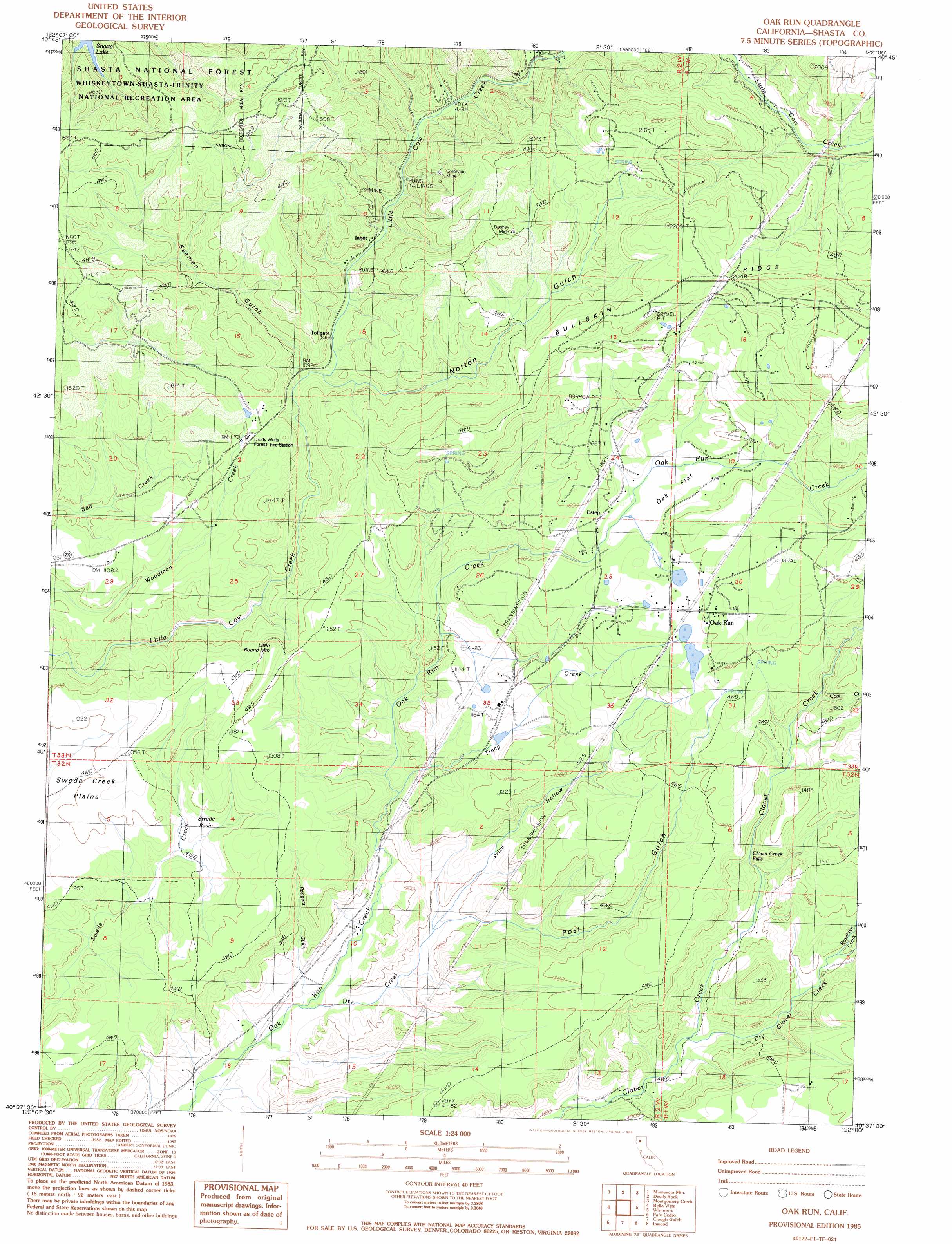
USGS Topo Quad 40122f1 - 1:24,000 scale
| Topo Map Name: | Oak Run |
| USGS Topo Quad ID: | 40122f1 |
| Print Size: | ca. 21 1/4" wide x 27" high |
| Southeast Coordinates: | 40.625° N latitude / 122° W longitude |
| Map Center Coordinates: | 40.6875° N latitude / 122.0625° W longitude |
| U.S. State: | CA |
| Filename: | o40122f1.jpg |
| Download Map JPG Image: | Oak Run topo map 1:24,000 scale |
| Map Type: | Topographic |
| Topo Series: | 7.5´ |
| Map Scale: | 1:24,000 |
| Source of Map Images: | United States Geological Survey (USGS) |
| Alternate Map Versions: |
Oak Run CA 1985, updated 1986 Download PDF Buy paper map Oak Run CA 1998, updated 2003 Download PDF Buy paper map Oak Run CA 2012 Download PDF Buy paper map Oak Run CA 2015 Download PDF Buy paper map |
| FStopo: | US Forest Service topo Oak Run is available: Download FStopo PDF Download FStopo TIF |
1:24,000 Topo Quads surrounding Oak Run
Hanland Peak |
Bollibokka Mountain |
Goose Gap |
Roaring Creek |
Chalk Mountain |
O'Brien |
Minnesota Mountain |
Devils Rock |
Montgomery Creek |
Hatchet Mountain Pass |
Project City |
Bella Vista |
Oak Run |
Whitmore |
Miller Mountain |
Enterprise |
Palo Cedro |
Clough Gulch |
Inwood |
Hagaman Gulch |
Cottonwood |
Balls Ferry |
Tuscan Buttes Ne |
Shingletown |
Manton |
> Back to 40122e1 at 1:100,000 scale
> Back to 40122a1 at 1:250,000 scale
> Back to U.S. Topo Maps home
Oak Run topo map: Gazetteer
Oak Run: Basins
Swede Basin elevation 267m 875′Oak Run: Falls
Clover Creek Falls elevation 343m 1125′Oak Run: Flats
Oak Flat elevation 451m 1479′Oak Run: Mines
Coronado Mine elevation 379m 1243′Donkey Mine elevation 538m 1765′
Oak Run: Populated Places
Furnaceville (historical) elevation 358m 1174′Ingot elevation 353m 1158′
Oak Run elevation 493m 1617′
Osborne elevation 566m 1856′
Wilkinson elevation 224m 734′
Oak Run: Streams
Coal Creek elevation 415m 1361′Dry Clover Creek elevation 255m 836′
Dry Creek elevation 202m 662′
Rosebriar Creek elevation 298m 977′
Tracy Creek elevation 265m 869′
Oak Run: Summits
Little Round Mountain elevation 385m 1263′Oak Run: Valleys
Norton Gulch elevation 348m 1141′Post Gulch elevation 237m 777′
Price Hollow elevation 237m 777′
Rodgers Gulch elevation 224m 734′
Seaman Gulch elevation 340m 1115′
Oak Run digital topo map on disk
Buy this Oak Run topo map showing relief, roads, GPS coordinates and other geographical features, as a high-resolution digital map file on DVD: