Lake Mountain Topo Map California
To zoom in, hover over the map of Lake Mountain
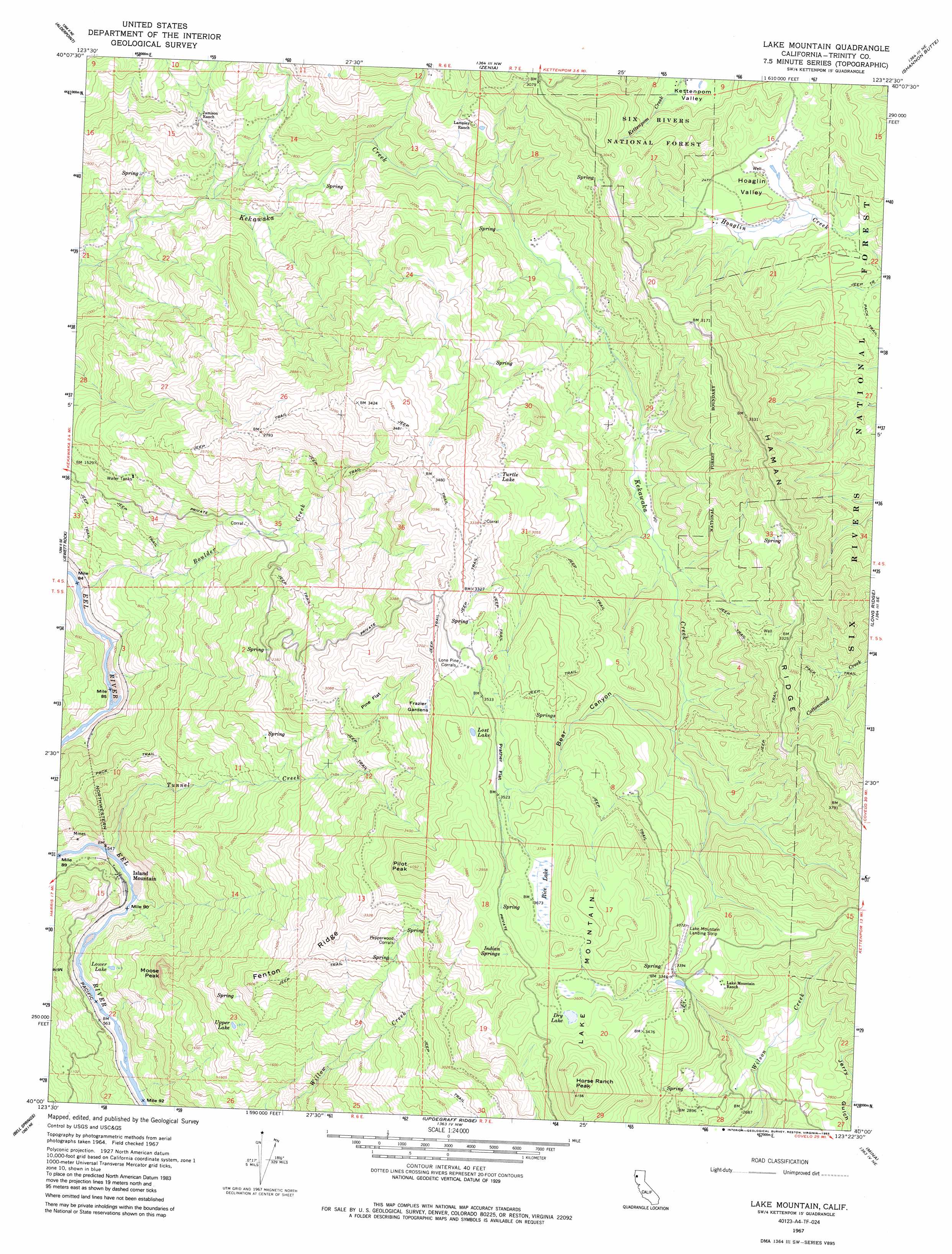
USGS Topo Quad 40123a4 - 1:24,000 scale
| Topo Map Name: | Lake Mountain |
| USGS Topo Quad ID: | 40123a4 |
| Print Size: | ca. 21 1/4" wide x 27" high |
| Southeast Coordinates: | 40° N latitude / 123.375° W longitude |
| Map Center Coordinates: | 40.0625° N latitude / 123.4375° W longitude |
| U.S. State: | CA |
| Filename: | o40123a4.jpg |
| Download Map JPG Image: | Lake Mountain topo map 1:24,000 scale |
| Map Type: | Topographic |
| Topo Series: | 7.5´ |
| Map Scale: | 1:24,000 |
| Source of Map Images: | United States Geological Survey (USGS) |
| Alternate Map Versions: |
Lake Mountain CA 1967, updated 1969 Download PDF Buy paper map Lake Mountain CA 1967, updated 1985 Download PDF Buy paper map Lake Mountain CA 1996, updated 2000 Download PDF Buy paper map Lake Mountain CA 1997, updated 2001 Download PDF Buy paper map Lake Mountain CA 2012 Download PDF Buy paper map Lake Mountain CA 2015 Download PDF Buy paper map |
| FStopo: | US Forest Service topo Lake Mountain is available: Download FStopo PDF Download FStopo TIF |
1:24,000 Topo Quads surrounding Lake Mountain
Blocksburg |
Black Lassic |
Ruth Lake |
Forest Glen |
|
Fort Seward |
Alderpoint |
Zenia |
Shannon Butte |
|
Harris |
Jewett Rock |
Lake Mountain |
Long Ridge |
|
Noble Butte |
Bell Springs |
Updegraff Ridge |
Mina |
Bluenose Ridge |
Leggett |
Tan Oak Park |
Iron Peak |
Covelo West |
Covelo East |
> Back to 40123a1 at 1:100,000 scale
> Back to 40122a1 at 1:250,000 scale
> Back to U.S. Topo Maps home
Lake Mountain topo map: Gazetteer
Lake Mountain: Airports
Lake Mountain Landing Strip elevation 1037m 3402′Lake Mountain: Areas
Frazier Gardens elevation 1063m 3487′Lake Mountain: Flats
Pine Flat elevation 939m 3080′Prather Flat elevation 1082m 3549′
Lake Mountain: Lakes
Dry Lake elevation 1107m 3631′Lost Lake elevation 1110m 3641′
Lower Lake elevation 230m 754′
Turtle Lake elevation 944m 3097′
Upper Lake elevation 572m 1876′
Lake Mountain: Mines
Island Mountain Mine elevation 246m 807′Lake Mountain: Populated Places
Island Mountain elevation 164m 538′Lake Mountain: Ridges
Fenton Ridge elevation 841m 2759′Haman Ridge elevation 1012m 3320′
Lake Mountain: Springs
Indian Springs elevation 1093m 3585′Lake Mountain: Streams
Boulder Creek elevation 110m 360′Tunnel Creek elevation 144m 472′
Lake Mountain: Summits
Horse Ranch Peak elevation 1240m 4068′Lake Mountain elevation 1170m 3838′
Moose Peak elevation 537m 1761′
Pilot Peak elevation 1211m 3973′
Lake Mountain: Swamps
Rice Lake elevation 1107m 3631′Lake Mountain: Valleys
Bear Canyon elevation 746m 2447′Hoaglin Valley elevation 708m 2322′
Lake Mountain digital topo map on disk
Buy this Lake Mountain topo map showing relief, roads, GPS coordinates and other geographical features, as a high-resolution digital map file on DVD: