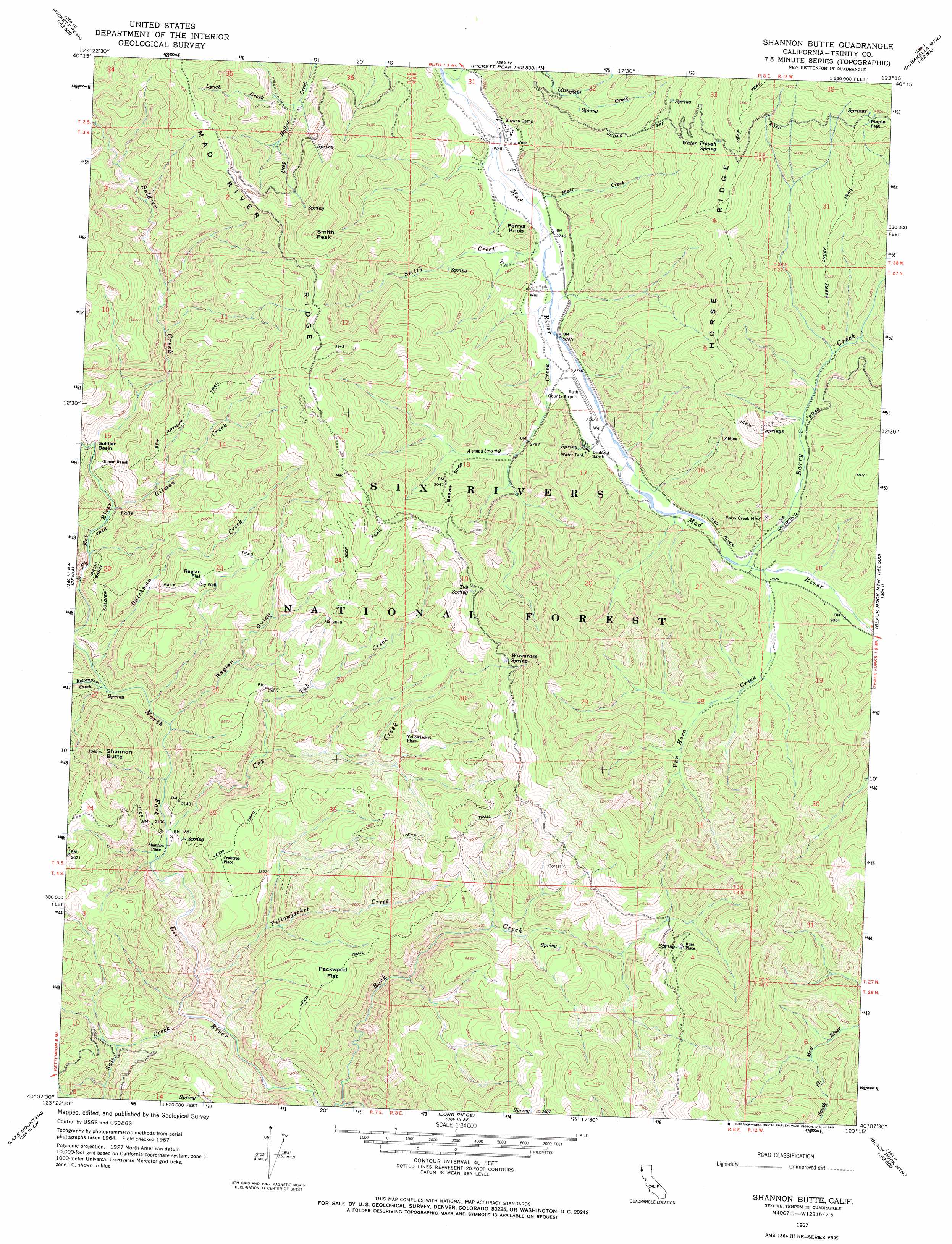
Shannon Butte Topo Map California
To zoom in, hover over the map of Shannon Butte
USGS Topo Quad 40123b3 - 1:24,000 scale
| Topo Map Name: | Shannon Butte |
| USGS Topo Quad ID: | 40123b3 |
| Print Size: | ca. 21 1/4" wide x 27" high |
| Southeast Coordinates: | 40.125° N latitude / 123.25° W longitude |
| Map Center Coordinates: | 40.1875° N latitude / 123.3125° W longitude |
| U.S. State: | CA |
| Filename: | o40123b3.jpg |
| Download Map JPG Image: | Shannon Butte topo map 1:24,000 scale |
| Map Type: | Topographic |
| Topo Series: | 7.5´ |
| Map Scale: | 1:24,000 |
| Source of Map Images: | United States Geological Survey (USGS) |
| Alternate Map Versions: |
Shannon Butte CA 1967, updated 1969 Download PDF Buy paper map Shannon Butte CA 1997, updated 2001 Download PDF Buy paper map Shannon Butte CA 2012 Download PDF Buy paper map Shannon Butte CA 2015 Download PDF Buy paper map |
| FStopo: | US Forest Service topo Shannon Butte is available: Download FStopo PDF Download FStopo TIF |
1:24,000 Topo Quads surrounding Shannon Butte
Dinsmore |
Sportshaven |
Naufus Creek |
Wildwood |
|
Black Lassic |
Ruth Lake |
Forest Glen |
Pony Buck Peak |
|
Alderpoint |
Zenia |
Shannon Butte |
Black Rock Mountain |
|
Jewett Rock |
Lake Mountain |
Long Ridge |
Wrights Ridge |
|
Bell Springs |
Updegraff Ridge |
Mina |
Bluenose Ridge |
Leech Lake Mountain |
> Back to 40123a1 at 1:100,000 scale
> Back to 40122a1 at 1:250,000 scale
> Back to U.S. Topo Maps home
Shannon Butte topo map: Gazetteer
Shannon Butte: Airports
Ruth Airport elevation 846m 2775′Shannon Butte: Basins
Soldier Basin elevation 610m 2001′Shannon Butte: Flats
Maple Flat elevation 1426m 4678′Packwood Flat elevation 840m 2755′
Raglan Flat elevation 824m 2703′
Shannon Butte: Mines
Barry Creek Mine elevation 931m 3054′Shannon Butte: Populated Places
Crabtree Place elevation 783m 2568′Russ Place elevation 1022m 3353′
Shannon Place elevation 564m 1850′
Yellowjacket Place elevation 841m 2759′
Shannon Butte: Ridges
Horse Ridge elevation 1295m 4248′Shannon Butte: Slopes
Beaver Slide elevation 912m 2992′Shannon Butte: Springs
Maple Spring elevation 1444m 4737′Surveyor Spring elevation 833m 2732′
Tub Spring elevation 1013m 3323′
Water Trough Spring elevation 1279m 4196′
Wiregrass Spring elevation 1015m 3330′
Shannon Butte: Streams
Armstrong Creek elevation 838m 2749′Barry Creek elevation 858m 2814′
Blair Creek elevation 836m 2742′
Cox Creek elevation 562m 1843′
Dutchman Creek elevation 585m 1919′
Gilman Creek elevation 599m 1965′
Kettenpom Creek elevation 582m 1909′
Littlefield Creek elevation 835m 2739′
Lynch Creek elevation 871m 2857′
Salt Creek elevation 549m 1801′
Smith Creek elevation 836m 2742′
Soldier Creek elevation 610m 2001′
Tub Creek elevation 659m 2162′
Van Horn Creek elevation 859m 2818′
Yellowjacket Creek elevation 555m 1820′
Shannon Butte: Summits
Perrys Knob elevation 919m 3015′Shannon Butte elevation 933m 3061′
Smith Peak elevation 1283m 4209′
Shannon Butte: Trails
Barry Creek Trail elevation 1211m 3973′Ben Arthur Trail elevation 906m 2972′
Soldier Basin Trail elevation 639m 2096′
Shannon Butte: Valleys
Raglan Gulch elevation 586m 1922′Shannon Butte digital topo map on disk
Buy this Shannon Butte topo map showing relief, roads, GPS coordinates and other geographical features, as a high-resolution digital map file on DVD: