Alderpoint Topo Map California
To zoom in, hover over the map of Alderpoint
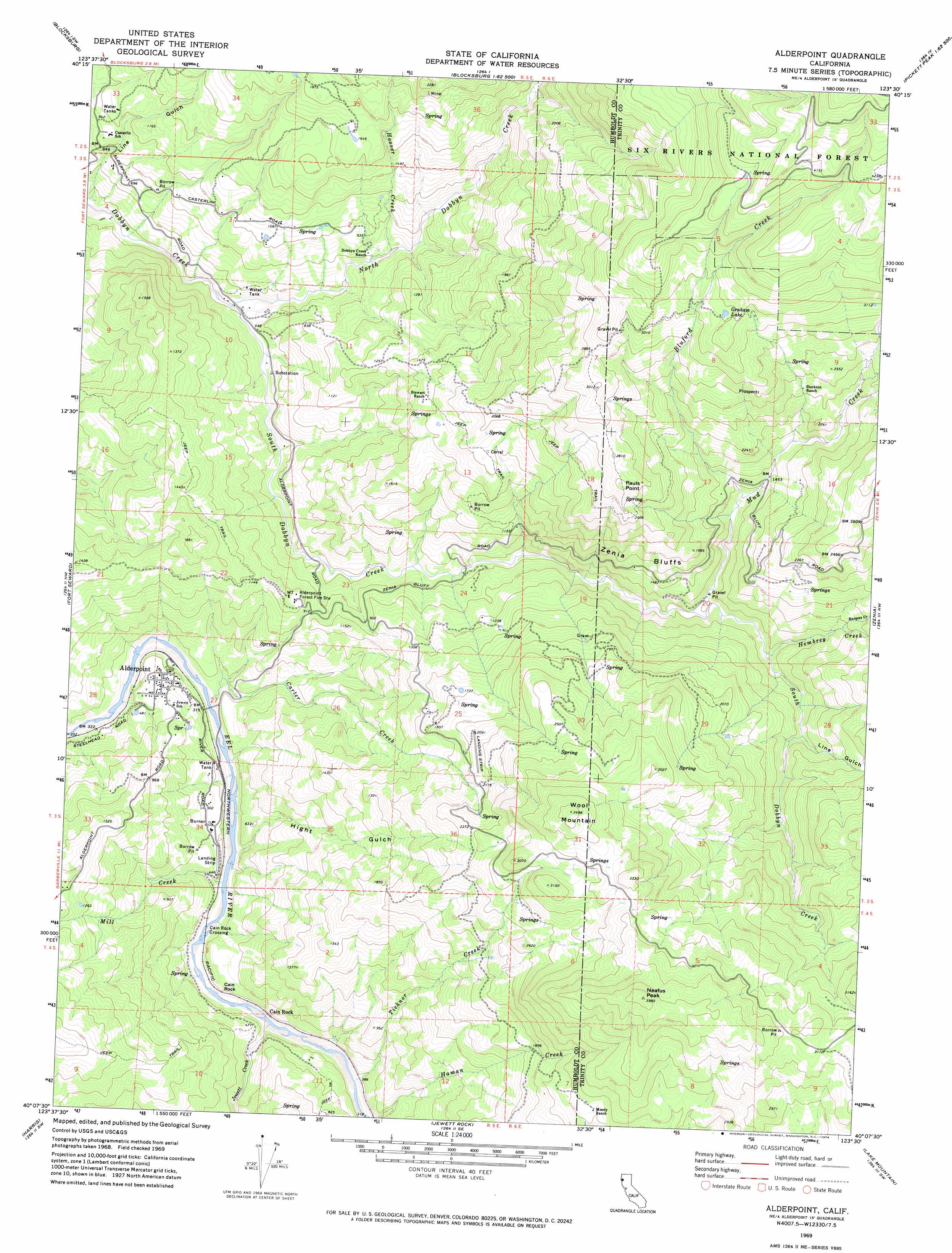
USGS Topo Quad 40123b5 - 1:24,000 scale
| Topo Map Name: | Alderpoint |
| USGS Topo Quad ID: | 40123b5 |
| Print Size: | ca. 21 1/4" wide x 27" high |
| Southeast Coordinates: | 40.125° N latitude / 123.5° W longitude |
| Map Center Coordinates: | 40.1875° N latitude / 123.5625° W longitude |
| U.S. State: | CA |
| Filename: | o40123b5.jpg |
| Download Map JPG Image: | Alderpoint topo map 1:24,000 scale |
| Map Type: | Topographic |
| Topo Series: | 7.5´ |
| Map Scale: | 1:24,000 |
| Source of Map Images: | United States Geological Survey (USGS) |
| Alternate Map Versions: |
Alderpoint CA 1969, updated 1974 Download PDF Buy paper map Alderpoint CA 1969, updated 1974 Download PDF Buy paper map Alderpoint CA 1997, updated 2001 Download PDF Buy paper map Alderpoint CA 2012 Download PDF Buy paper map Alderpoint CA 2015 Download PDF Buy paper map |
| FStopo: | US Forest Service topo Alderpoint is available: Download FStopo PDF Download FStopo TIF |
1:24,000 Topo Quads surrounding Alderpoint
Bridgeville |
Larabee Valley |
Dinsmore |
Sportshaven |
Naufus Creek |
Myers Flat |
Blocksburg |
Black Lassic |
Ruth Lake |
Forest Glen |
Miranda |
Fort Seward |
Alderpoint |
Zenia |
Shannon Butte |
Garberville |
Harris |
Jewett Rock |
Lake Mountain |
Long Ridge |
Piercy |
Noble Butte |
Bell Springs |
Updegraff Ridge |
Mina |
> Back to 40123a1 at 1:100,000 scale
> Back to 40122a1 at 1:250,000 scale
> Back to U.S. Topo Maps home
Alderpoint topo map: Gazetteer
Alderpoint: Bridges
Cain Rock Crossing elevation 89m 291′Alderpoint: Capes
Pauls Point elevation 859m 2818′Alderpoint: Cliffs
Zenia Bluffs elevation 490m 1607′Alderpoint: Lakes
Graham Lake elevation 972m 3188′Alderpoint: Pillars
Cain Rock elevation 140m 459′Alderpoint: Populated Places
Alderpoint elevation 144m 472′Cain Rock elevation 116m 380′
Alderpoint: Streams
Bluford Creek elevation 390m 1279′Burgess Creek elevation 461m 1512′
Carter Creek elevation 85m 278′
Hembrey Creek elevation 328m 1076′
Hoover Creek elevation 244m 800′
Jewett Creek elevation 93m 305′
Mill Creek elevation 98m 321′
Mud Creek elevation 297m 974′
North Dobbyn Creek elevation 122m 400′
South Dobbyn Creek elevation 122m 400′
Ticknor Creek elevation 97m 318′
Alderpoint: Summits
Neafus Peak elevation 1201m 3940′Wool Mountain elevation 1059m 3474′
Alderpoint: Valleys
Hight Gulch elevation 102m 334′Line Gulch elevation 401m 1315′
Alderpoint digital topo map on disk
Buy this Alderpoint topo map showing relief, roads, GPS coordinates and other geographical features, as a high-resolution digital map file on DVD: