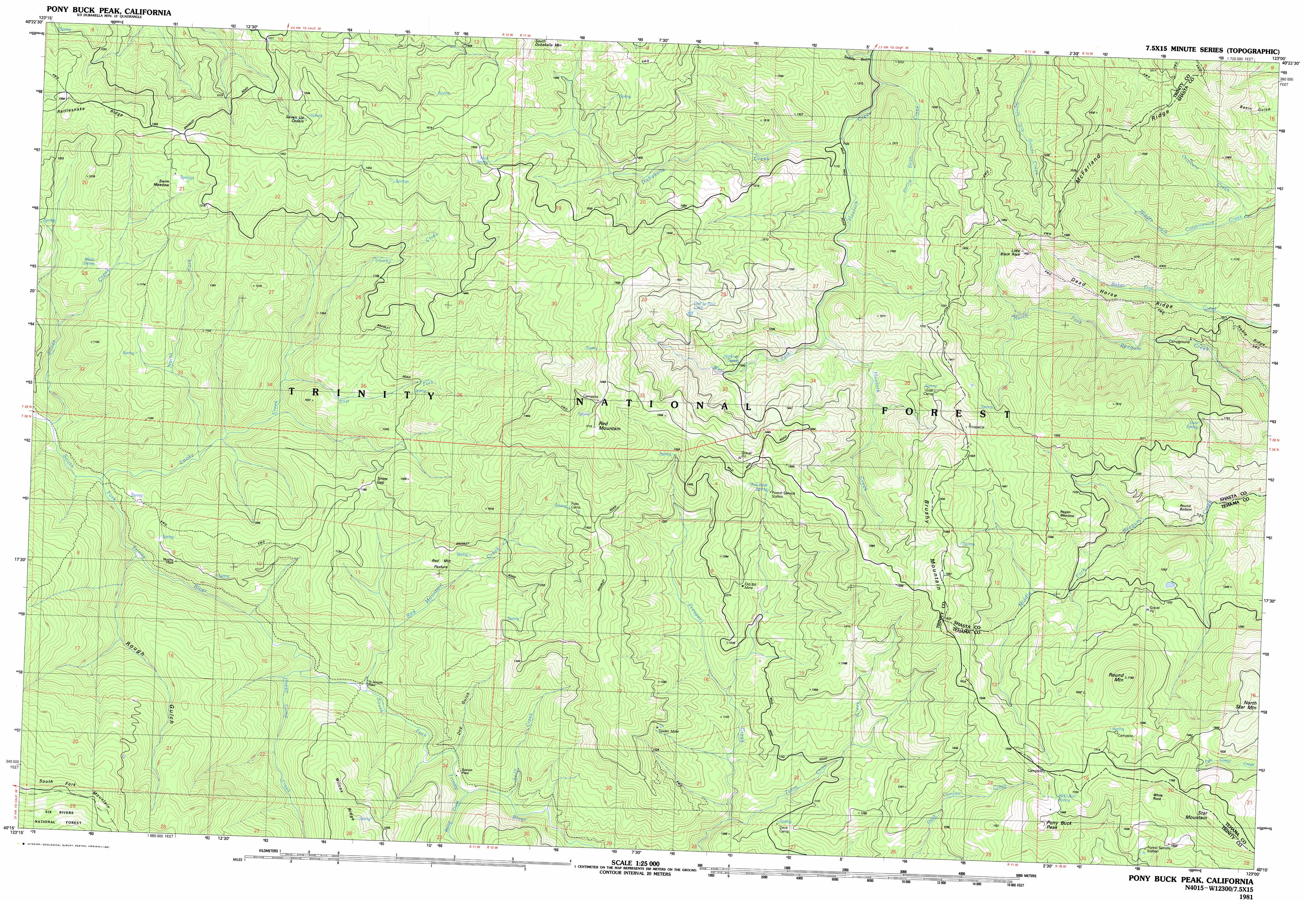
Pony Buck Peak Topo Map California
To zoom in, hover over the map of Pony Buck Peak
USGS Topo Quad 40123c1 - 1:25,000 scale
| Topo Map Name: | Pony Buck Peak |
| USGS Topo Quad ID: | 40123c1 |
| Print Size: | ca. 39" wide x 24" high |
| Southeast Coordinates: | 40.25° N latitude / 123° W longitude |
| Map Center Coordinates: | 40.3125° N latitude / 123.125° W longitude |
| U.S. State: | CA |
| Filename: | k40123c1.jpg |
| Download Map JPG Image: | Pony Buck Peak topo map 1:25,000 scale |
| Map Type: | Topographic |
| Topo Series: | 7.5´x15´ |
| Map Scale: | 1:25,000 |
| Source of Map Images: | United States Geological Survey (USGS) |
| Alternate Map Versions: |
Pony Buck Peak CA 1981, updated 1981 Download PDF Buy paper map |
| FStopo: | US Forest Service topo Pony Buck Peak is available: Download FStopo PDF Download FStopo TIF |
1:24,000 Topo Quads surrounding Pony Buck Peak
Halfway Ridge |
Hayfork |
Hayfork Summit |
Hossimbim Mountain |
Bully Choop Mountain |
Naufus Creek |
Wildwood |
Arbuckle Mountain |
||
Forest Glen |
Pony Buck Peak |
Beegum |
||
Shannon Butte |
Black Rock Mountain |
Tomhead Mountain |
||
Long Ridge |
Wrights Ridge |
South Yolla Bolly Mountains |
> Back to 40123a1 at 1:100,000 scale
> Back to 40122a1 at 1:250,000 scale
> Back to U.S. Topo Maps home
Pony Buck Peak topo map: Gazetteer
Pony Buck Peak: Areas
Regan Meadow elevation 1326m 4350′Pony Buck Peak: Bends
Round Bottom elevation 1017m 3336′Pony Buck Peak: Flats
Red Mountain Pasture elevation 1091m 3579′Swim Meadow elevation 1256m 4120′
Pony Buck Peak: Gaps
Snow Gap elevation 1156m 3792′Pony Buck Peak: Lakes
Hell to Find Lake elevation 1466m 4809′Pony Buck Peak: Mines
Old Bill Mine elevation 1243m 4078′Spider Mine elevation 1266m 4153′
Pony Buck Peak: Pillars
Little Black Rock elevation 1453m 4767′White Rock elevation 1748m 5734′
Pony Buck Peak: Populated Places
Bramlet Place elevation 857m 2811′Murphy Place elevation 1005m 3297′
Pony Buck Peak: Ridges
Dead Horse Ridge elevation 1056m 3464′McFarland Ridge elevation 1426m 4678′
Pony Buck Peak: Springs
Gum Spring elevation 1142m 3746′Hackney Spring elevation 1286m 4219′
McCullah Spring elevation 1644m 5393′
Mud Spring elevation 1599m 5246′
Pine Root Spring elevation 1444m 4737′
Seven Up Cedars Spring elevation 1399m 4589′
Silver Spring elevation 1062m 3484′
Pony Buck Peak: Streams
Bierce Creek elevation 835m 2739′Dubakella Creek elevation 1110m 3641′
East Fork Smoky Creek elevation 865m 2837′
Happy Camp Creek elevation 813m 2667′
Little Silver Creek elevation 756m 2480′
North Fork Smoky Creek elevation 800m 2624′
Oliphant Creek elevation 907m 2975′
Red Mountain Creek elevation 822m 2696′
Silver Creek elevation 757m 2483′
Smoky Creek elevation 767m 2516′
Soap Creek elevation 847m 2778′
String Bean Creek elevation 1078m 3536′
Texas Chow Creek elevation 961m 3152′
Pony Buck Peak: Summits
Brushy Mountain elevation 1630m 5347′Pony Buck Peak elevation 1707m 5600′
Red Mountain elevation 1709m 5606′
Round Mountain elevation 1771m 5810′
Star Mountain elevation 1845m 6053′
Pony Buck Peak: Valleys
Dog Gulch elevation 899m 2949′Murphy Gulch elevation 814m 2670′
Rough Gulch elevation 799m 2621′
Pony Buck Peak digital topo map on disk
Buy this Pony Buck Peak topo map showing relief, roads, GPS coordinates and other geographical features, as a high-resolution digital map file on DVD: