Yager Junction Topo Map California
To zoom in, hover over the map of Yager Junction
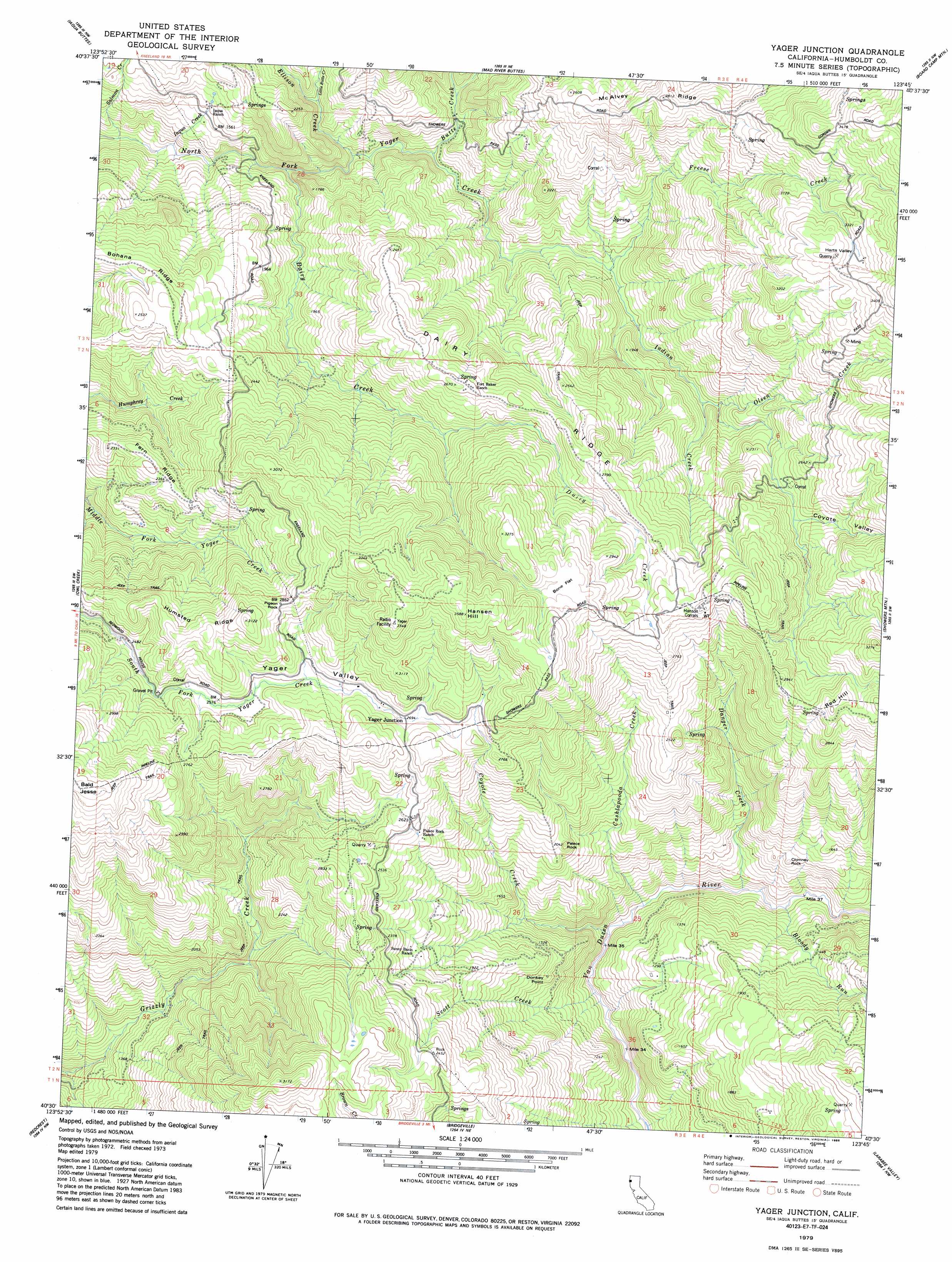
USGS Topo Quad 40123e7 - 1:24,000 scale
| Topo Map Name: | Yager Junction |
| USGS Topo Quad ID: | 40123e7 |
| Print Size: | ca. 21 1/4" wide x 27" high |
| Southeast Coordinates: | 40.5° N latitude / 123.75° W longitude |
| Map Center Coordinates: | 40.5625° N latitude / 123.8125° W longitude |
| U.S. State: | CA |
| Filename: | o40123e7.jpg |
| Download Map JPG Image: | Yager Junction topo map 1:24,000 scale |
| Map Type: | Topographic |
| Topo Series: | 7.5´ |
| Map Scale: | 1:24,000 |
| Source of Map Images: | United States Geological Survey (USGS) |
| Alternate Map Versions: |
Yager Junction CA 1979, updated 1979 Download PDF Buy paper map Yager Junction CA 1979, updated 1985 Download PDF Buy paper map Yager Junction CA 2012 Download PDF Buy paper map Yager Junction CA 2015 Download PDF Buy paper map |
1:24,000 Topo Quads surrounding Yager Junction
Arcata South |
Korbel |
Maple Creek |
Grouse Mountain |
Hennessy Peak |
Mcwhinney Creek |
Iaqua Buttes |
Mad River Buttes |
Board Camp Mountain |
Sims Mountain |
Hydesville |
Owl Creek |
Yager Junction |
Showers Mountain |
Blake Mountain |
Scotia |
Redcrest |
Bridgeville |
Larabee Valley |
Dinsmore |
Bull Creek |
Weott |
Myers Flat |
Blocksburg |
Black Lassic |
> Back to 40123e1 at 1:100,000 scale
> Back to 40122a1 at 1:250,000 scale
> Back to U.S. Topo Maps home
Yager Junction topo map: Gazetteer
Yager Junction: Capes
Donkey Point elevation 463m 1519′Yager Junction: Flats
Bone Flat elevation 945m 3100′Yager Junction: Pillars
Chimney Rock elevation 439m 1440′Palace Rock elevation 600m 1968′
Pigeon Rock elevation 882m 2893′
Yager Junction: Populated Places
Yager Junction elevation 829m 2719′Yager Junction: Ridges
Dairy Ridge elevation 803m 2634′Fern Ridge elevation 735m 2411′
Humsted Ridge elevation 893m 2929′
McAlvey Ridge elevation 858m 2814′
Yager Junction: Streams
Bloody Run elevation 267m 875′Butte Creek elevation 425m 1394′
Cashlapooda Creek elevation 233m 764′
Coyote Creek elevation 229m 751′
Dairy Creek elevation 391m 1282′
Danger Creek elevation 256m 839′
Ellison Creek elevation 403m 1322′
Freese Creek elevation 472m 1548′
Iaqua Creek elevation 359m 1177′
Indian Creek elevation 472m 1548′
Little Butte Creek elevation 492m 1614′
Olsen Creek elevation 537m 1761′
Salmon Creek elevation 310m 1017′
Scott Creek elevation 218m 715′
Yager Junction: Summits
Hansen Hill elevation 1088m 3569′Red Hill elevation 915m 3001′
Yager Junction: Valleys
Coyote Valley elevation 720m 2362′Harts Valley elevation 983m 3225′
Yager Valley elevation 768m 2519′
Yager Junction digital topo map on disk
Buy this Yager Junction topo map showing relief, roads, GPS coordinates and other geographical features, as a high-resolution digital map file on DVD: