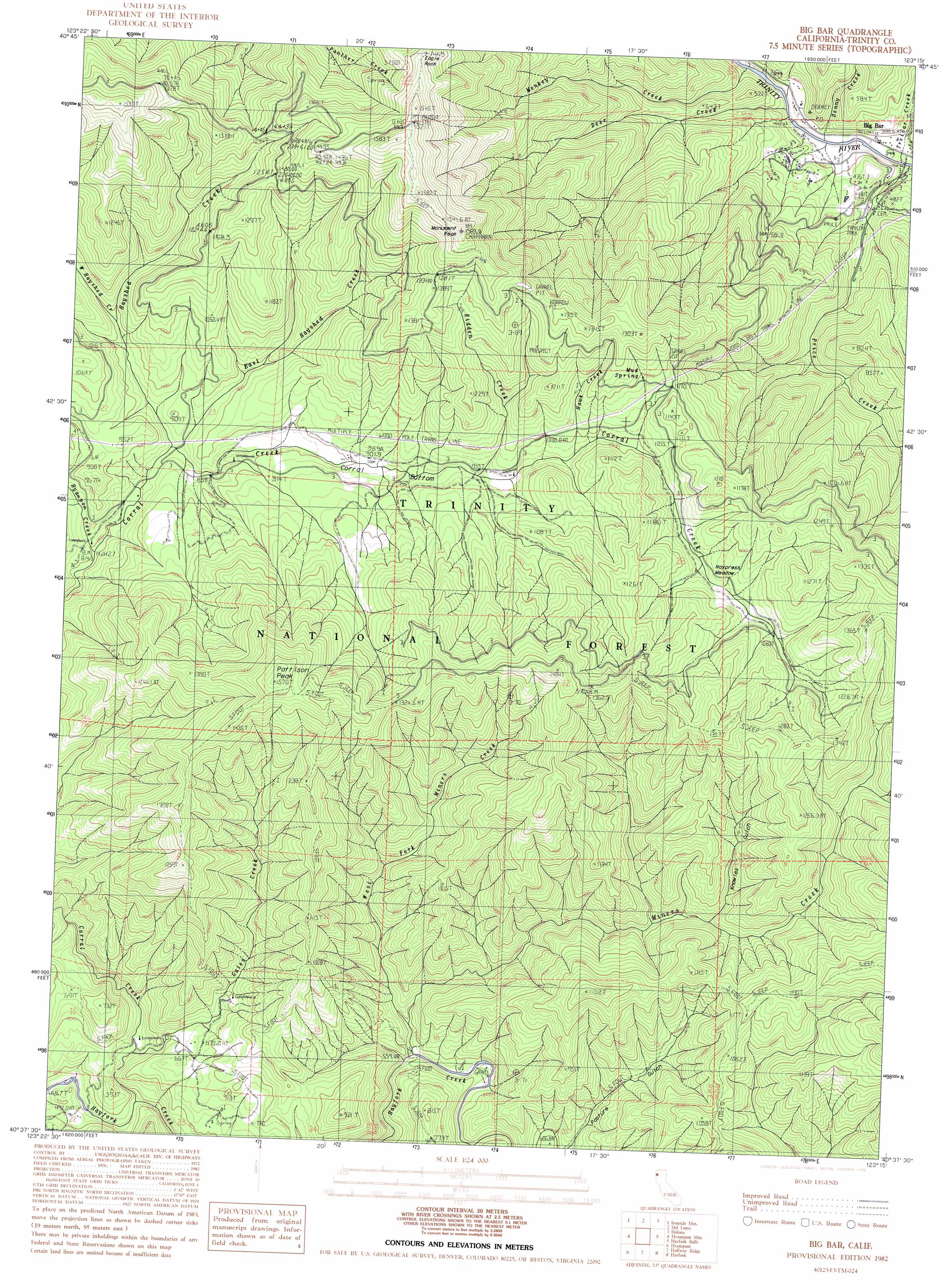
Big Bar Topo Map California
To zoom in, hover over the map of Big Bar
USGS Topo Quad 40123f3 - 1:24,000 scale
| Topo Map Name: | Big Bar |
| USGS Topo Quad ID: | 40123f3 |
| Print Size: | ca. 21 1/4" wide x 27" high |
| Southeast Coordinates: | 40.625° N latitude / 123.25° W longitude |
| Map Center Coordinates: | 40.6875° N latitude / 123.3125° W longitude |
| U.S. State: | CA |
| Filename: | o40123f3.jpg |
| Download Map JPG Image: | Big Bar topo map 1:24,000 scale |
| Map Type: | Topographic |
| Topo Series: | 7.5´ |
| Map Scale: | 1:24,000 |
| Source of Map Images: | United States Geological Survey (USGS) |
| Alternate Map Versions: |
Big Bar CA 1982, updated 1982 Download PDF Buy paper map Big Bar CA 1982, updated 1982 Download PDF Buy paper map Big Bar CA 1998, updated 2003 Download PDF Buy paper map Big Bar CA 2012 Download PDF Buy paper map Big Bar CA 2015 Download PDF Buy paper map |
| FStopo: | US Forest Service topo Big Bar is available: Download FStopo PDF Download FStopo TIF |
1:24,000 Topo Quads surrounding Big Bar
Salyer |
Denny |
Jim Jam Ridge |
Thurston Peaks |
Mount Hilton |
Hennessy Peak |
Ironside Mountain |
Del Loma |
Helena |
Dedrick |
Sims Mountain |
Hyampom Mountain |
Big Bar |
Hayfork Bally |
Junction City |
Blake Mountain |
Hyampom |
Halfway Ridge |
Hayfork |
Hayfork Summit |
Dinsmore |
Sportshaven |
Naufus Creek |
Wildwood |
> Back to 40123e1 at 1:100,000 scale
> Back to 40122a1 at 1:250,000 scale
> Back to U.S. Topo Maps home
Big Bar topo map: Gazetteer
Big Bar: Bends
Corral Bottom elevation 915m 3001′Big Bar: Flats
Haypress Meadow elevation 1073m 3520′Big Bar: Pillars
Eagle Rock elevation 1394m 4573′Big Bar: Populated Places
Big Bar elevation 380m 1246′Big Bar: Post Offices
Big Bar Post Office elevation 389m 1276′Big Bar: Springs
Mud Spring elevation 1097m 3599′Big Bar: Streams
Bidden Creek elevation 941m 3087′Deer Creek elevation 386m 1266′
East Hayshed Creek elevation 870m 2854′
Gates Creek elevation 537m 1761′
Hawk Creek elevation 984m 3228′
Hayshed Creek elevation 865m 2837′
Hyampom Creek elevation 819m 2687′
Miners Creek elevation 559m 1833′
Monkey Creek elevation 382m 1253′
Price Creek elevation 360m 1181′
Treloar Creek elevation 362m 1187′
West Fork Miners Creek elevation 617m 2024′
West Hayshed Creek elevation 954m 3129′
Big Bar: Summits
Gates Mountain elevation 902m 2959′Monument Peak elevation 1507m 4944′
Pattison Peak elevation 1527m 5009′
Big Bar: Valleys
Knowles Gulch elevation 851m 2791′Pasture Gulch elevation 625m 2050′
Big Bar digital topo map on disk
Buy this Big Bar topo map showing relief, roads, GPS coordinates and other geographical features, as a high-resolution digital map file on DVD: