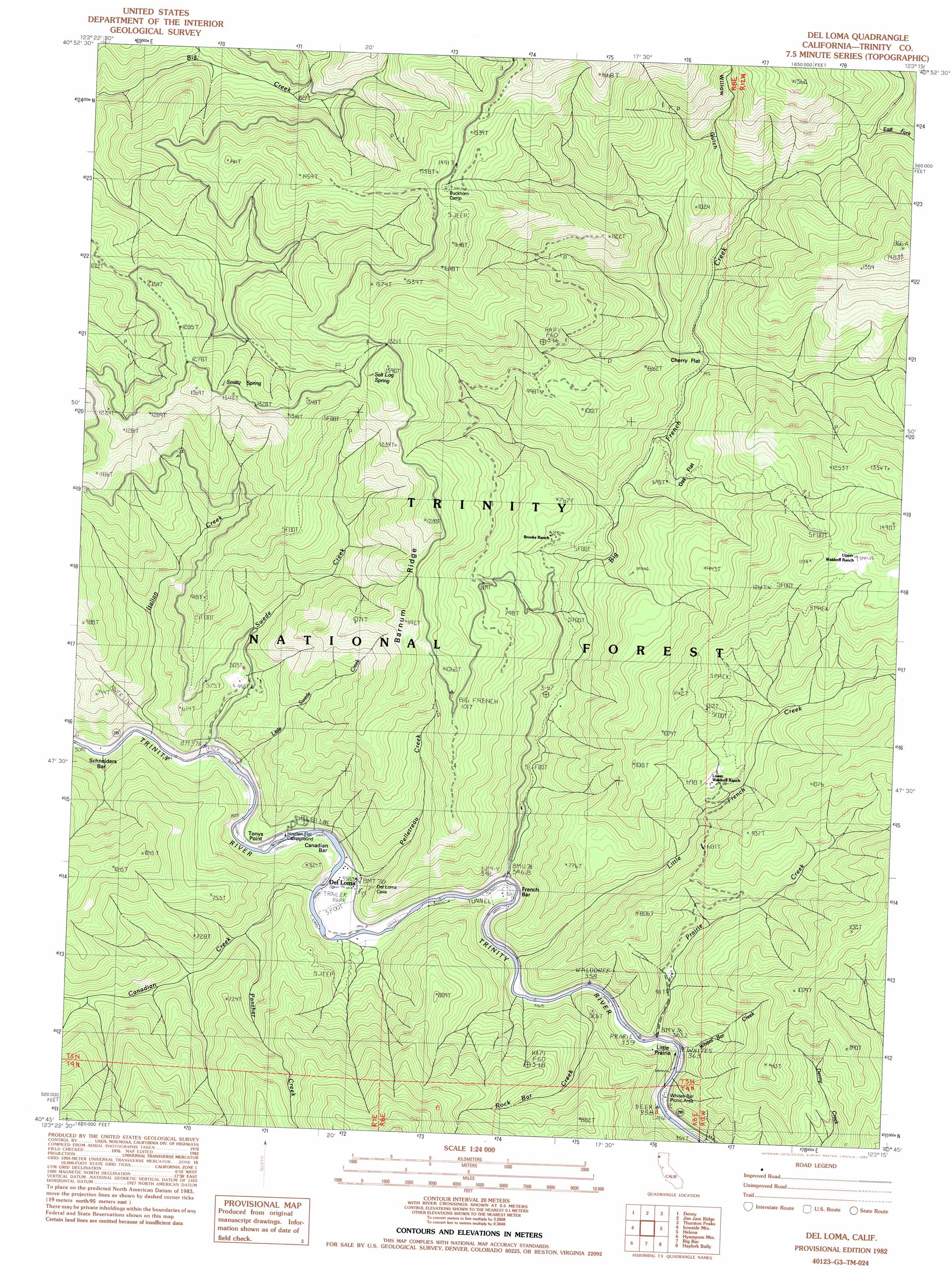
Del Loma Topo Map California
To zoom in, hover over the map of Del Loma
USGS Topo Quad 40123g3 - 1:24,000 scale
| Topo Map Name: | Del Loma |
| USGS Topo Quad ID: | 40123g3 |
| Print Size: | ca. 21 1/4" wide x 27" high |
| Southeast Coordinates: | 40.75° N latitude / 123.25° W longitude |
| Map Center Coordinates: | 40.8125° N latitude / 123.3125° W longitude |
| U.S. State: | CA |
| Filename: | o40123g3.jpg |
| Download Map JPG Image: | Del Loma topo map 1:24,000 scale |
| Map Type: | Topographic |
| Topo Series: | 7.5´ |
| Map Scale: | 1:24,000 |
| Source of Map Images: | United States Geological Survey (USGS) |
| Alternate Map Versions: |
Del Loma CA 1982, updated 1982 Download PDF Buy paper map Del Loma CA 1982, updated 1985 Download PDF Buy paper map Del Loma CA 1998, updated 2003 Download PDF Buy paper map Del Loma CA 2012 Download PDF Buy paper map Del Loma CA 2015 Download PDF Buy paper map |
| FStopo: | US Forest Service topo Del Loma is available: Download FStopo PDF Download FStopo TIF |
1:24,000 Topo Quads surrounding Del Loma
Tish Tang Point |
Trinity Mountain |
Dees Peak |
Cecil Lake |
Thompson Peak |
Salyer |
Denny |
Jim Jam Ridge |
Thurston Peaks |
Mount Hilton |
Hennessy Peak |
Ironside Mountain |
Del Loma |
Helena |
Dedrick |
Sims Mountain |
Hyampom Mountain |
Big Bar |
Hayfork Bally |
Junction City |
Blake Mountain |
Hyampom |
Halfway Ridge |
Hayfork |
Hayfork Summit |
> Back to 40123e1 at 1:100,000 scale
> Back to 40122a1 at 1:250,000 scale
> Back to U.S. Topo Maps home
Del Loma topo map: Gazetteer
Del Loma: Areas
Little Prairie elevation 502m 1646′Del Loma: Bars
Canadian Bar elevation 345m 1131′French Bar elevation 406m 1332′
Schneiders Bar elevation 314m 1030′
Del Loma: Capes
Tonys Point elevation 393m 1289′Del Loma: Flats
Cherry Flat elevation 703m 2306′Oak Flat elevation 702m 2303′
Taylors Flat elevation 425m 1394′
Del Loma: Populated Places
Del Loma elevation 356m 1167′Del Loma: Ridges
Barnum Ridge elevation 1069m 3507′Del Loma: Springs
Salt Log Spring elevation 1270m 4166′Smitty Spring elevation 1255m 4117′
Del Loma: Streams
Big French Creek elevation 347m 1138′Canadian Creek elevation 326m 1069′
Denny Creek elevation 539m 1768′
East Fork Big French Creek elevation 779m 2555′
Italian Creek elevation 370m 1213′
Little French Creek elevation 420m 1377′
Little Swede Creek elevation 333m 1092′
Panther Creek elevation 423m 1387′
Pelletreau Creek elevation 348m 1141′
Prairie Creek elevation 369m 1210′
Rock Bar Creek elevation 373m 1223′
Swede Creek elevation 313m 1026′
Whites Bar Creek elevation 414m 1358′
Del Loma: Trails
New River Divide Trail elevation 1475m 4839′Del Loma: Valleys
Willow Gulch elevation 703m 2306′Del Loma digital topo map on disk
Buy this Del Loma topo map showing relief, roads, GPS coordinates and other geographical features, as a high-resolution digital map file on DVD: