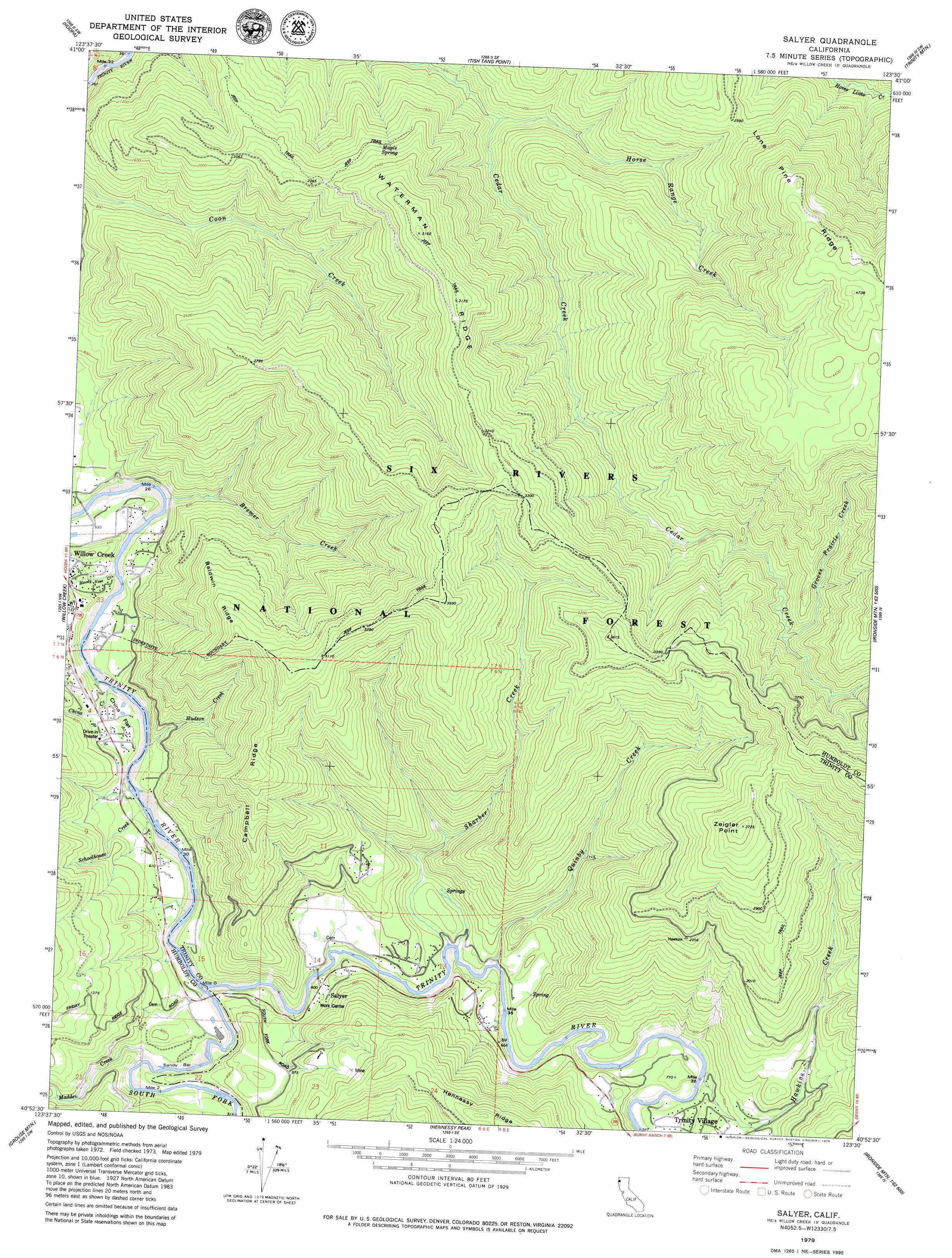
Salyer Topo Map California
To zoom in, hover over the map of Salyer
USGS Topo Quad 40123h5 - 1:24,000 scale
| Topo Map Name: | Salyer |
| USGS Topo Quad ID: | 40123h5 |
| Print Size: | ca. 21 1/4" wide x 27" high |
| Southeast Coordinates: | 40.875° N latitude / 123.5° W longitude |
| Map Center Coordinates: | 40.9375° N latitude / 123.5625° W longitude |
| U.S. State: | CA |
| Filename: | o40123h5.jpg |
| Download Map JPG Image: | Salyer topo map 1:24,000 scale |
| Map Type: | Topographic |
| Topo Series: | 7.5´ |
| Map Scale: | 1:24,000 |
| Source of Map Images: | United States Geological Survey (USGS) |
| Alternate Map Versions: |
Salyer CA 1979, updated 1979 Download PDF Buy paper map Salyer CA 1997, updated 2001 Download PDF Buy paper map Salyer CA 2012 Download PDF Buy paper map Salyer CA 2015 Download PDF Buy paper map |
| FStopo: | US Forest Service topo Salyer is available: Download FStopo PDF Download FStopo TIF |
1:24,000 Topo Quads surrounding Salyer
French Camp Ridge |
Weitchpec |
Hopkins Butte |
Salmon Mountain |
Youngs Peak |
Hupa Mountain |
Hoopa |
Tish Tang Point |
Trinity Mountain |
Dees Peak |
Lord-Ellis Summit |
Willow Creek |
Salyer |
Denny |
Jim Jam Ridge |
Maple Creek |
Grouse Mountain |
Hennessy Peak |
Ironside Mountain |
Del Loma |
Mad River Buttes |
Board Camp Mountain |
Sims Mountain |
Hyampom Mountain |
Big Bar |
> Back to 40123e1 at 1:100,000 scale
> Back to 40122a1 at 1:250,000 scale
> Back to U.S. Topo Maps home
Salyer topo map: Gazetteer
Salyer: Capes
Zeigler Point elevation 1130m 3707′Salyer: Flats
China Flat elevation 163m 534′Salyer: Populated Places
Salyer elevation 189m 620′Trinity Village elevation 210m 688′
Salyer: Post Offices
Salyer Post Office elevation 188m 616′Salyer: Ridges
Baldwin Ridge elevation 735m 2411′Campbell Ridge elevation 837m 2746′
Lone Pine Ridge elevation 1131m 3710′
Waterman Ridge elevation 954m 3129′
Salyer: Springs
Maple Spring elevation 625m 2050′Salyer: Streams
Bloody Nose Creek elevation 134m 439′Bremer Creek elevation 147m 482′
Butterfly Creek elevation 136m 446′
China Creek elevation 138m 452′
Groves Prairie Creek elevation 722m 2368′
Hawkins Creek elevation 168m 551′
Horse Range Creek elevation 262m 859′
Hudson Creek elevation 145m 475′
Old Campbell Creek elevation 167m 547′
Quinby Creek elevation 168m 551′
Schoolhouse Creek elevation 144m 472′
Sharber Creek elevation 161m 528′
South Fork Trinity River elevation 136m 446′
Victor Creek elevation 168m 551′
Salyer digital topo map on disk
Buy this Salyer topo map showing relief, roads, GPS coordinates and other geographical features, as a high-resolution digital map file on DVD: