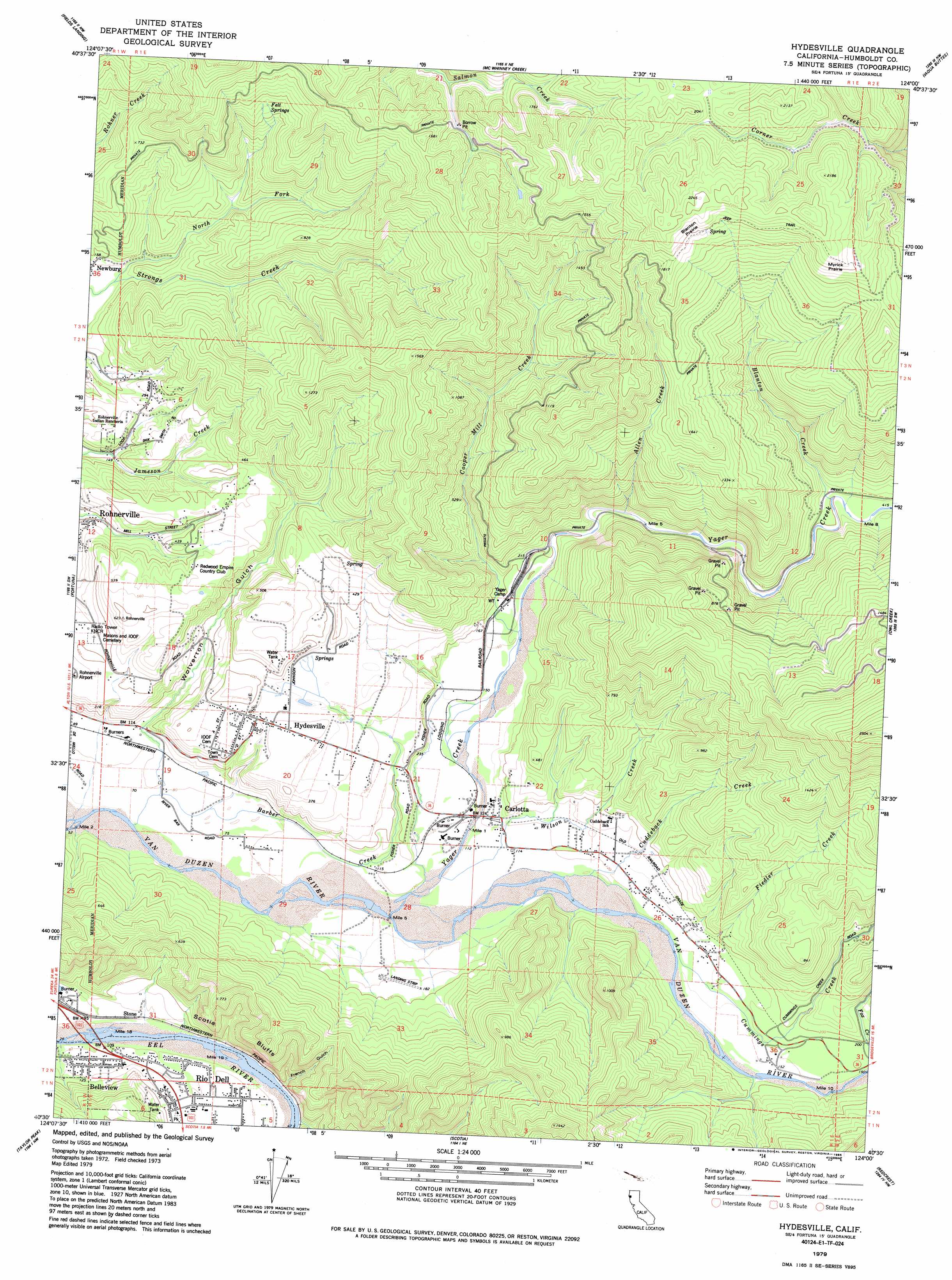
Hydesville Topo Map California
To zoom in, hover over the map of Hydesville
USGS Topo Quad 40124e1 - 1:24,000 scale
| Topo Map Name: | Hydesville |
| USGS Topo Quad ID: | 40124e1 |
| Print Size: | ca. 21 1/4" wide x 27" high |
| Southeast Coordinates: | 40.5° N latitude / 124° W longitude |
| Map Center Coordinates: | 40.5625° N latitude / 124.0625° W longitude |
| U.S. State: | CA |
| Filename: | o40124e1.jpg |
| Download Map JPG Image: | Hydesville topo map 1:24,000 scale |
| Map Type: | Topographic |
| Topo Series: | 7.5´ |
| Map Scale: | 1:24,000 |
| Source of Map Images: | United States Geological Survey (USGS) |
| Alternate Map Versions: |
Hydesville CA 1979, updated 1985 Download PDF Buy paper map Hydesville CA 2012 Download PDF Buy paper map Hydesville CA 2015 Download PDF Buy paper map |
1:24,000 Topo Quads surrounding Hydesville
Eureka |
Arcata South |
Korbel |
Maple Creek |
|
Cannibal Island |
Fields Landing |
Mcwhinney Creek |
Iaqua Buttes |
Mad River Buttes |
Ferndale |
Fortuna |
Hydesville |
Owl Creek |
Yager Junction |
Capetown |
Taylor Peak |
Scotia |
Redcrest |
Bridgeville |
Petrolia |
Buckeye Mountain |
Bull Creek |
Weott |
Myers Flat |
> Back to 40124e1 at 1:100,000 scale
> Back to 40124a1 at 1:250,000 scale
> Back to U.S. Topo Maps home
Hydesville topo map: Gazetteer
Hydesville: Cliffs
Scotia Bluffs elevation 133m 436′Hydesville: Flats
Blanton Prairie elevation 607m 1991′Myrick Prairie elevation 649m 2129′
Hydesville: Populated Places
Belleview elevation 34m 111′Carlotta elevation 40m 131′
Hydesville elevation 111m 364′
Newburg elevation 37m 121′
Stone elevation 28m 91′
Hydesville: Springs
Felt Springs elevation 273m 895′Hydesville: Streams
Allen Creek elevation 86m 282′Barber Creek elevation 20m 65′
Blanton Creek elevation 123m 403′
Cooper Mill Creek elevation 50m 164′
Cuddeback Creek elevation 36m 118′
Cummings Creek elevation 38m 124′
Fiedler Creek elevation 64m 209′
Fox Creek elevation 59m 193′
Nanning Creek elevation 25m 82′
North Fork Strongs Creek elevation 35m 114′
Wilson Creek elevation 32m 104′
Yager Creek elevation 28m 91′
Hydesville: Valleys
French Gulch elevation 41m 134′Wolverton Gulch elevation 36m 118′
Hydesville digital topo map on disk
Buy this Hydesville topo map showing relief, roads, GPS coordinates and other geographical features, as a high-resolution digital map file on DVD: