Eureka Topo Map California
To zoom in, hover over the map of Eureka
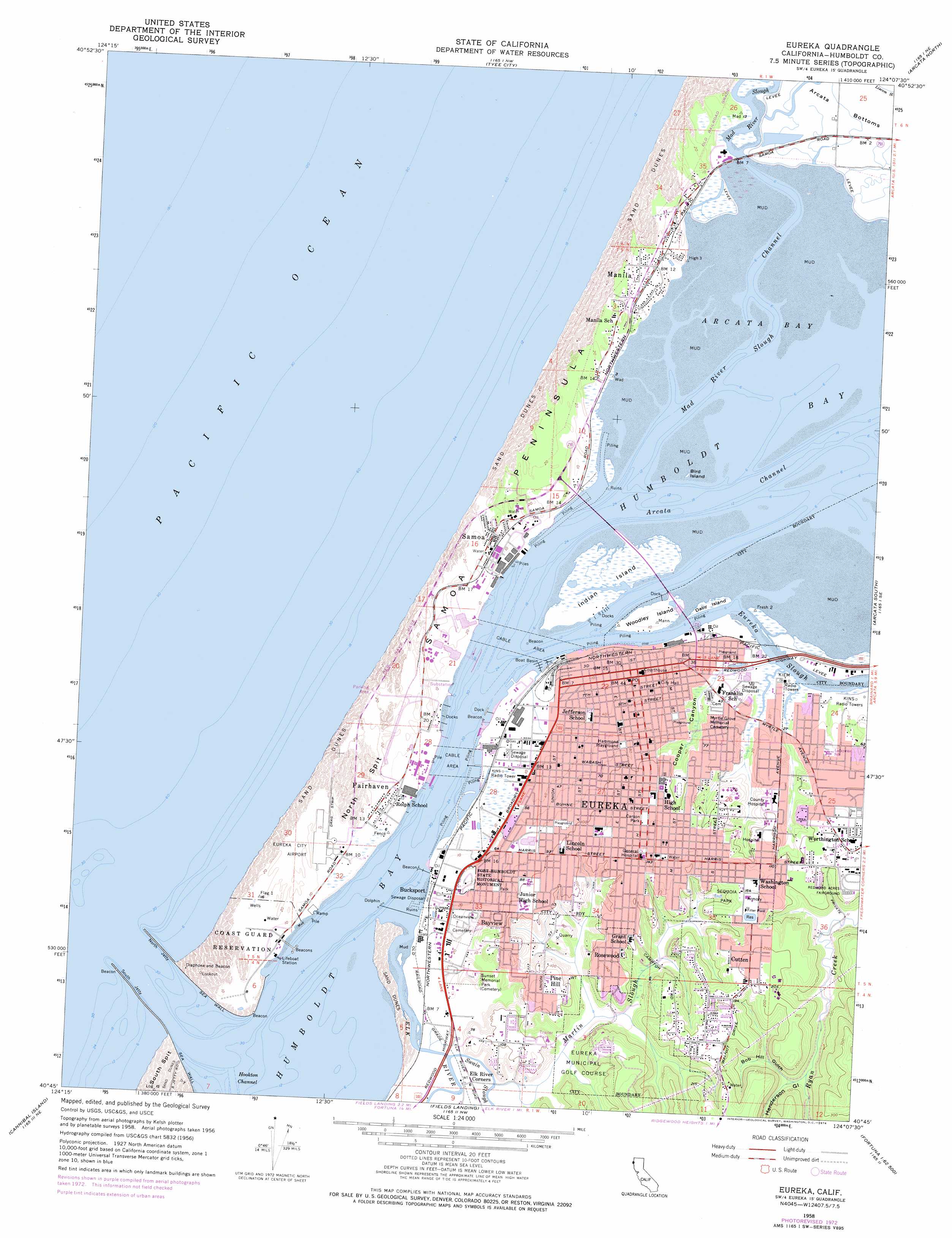
USGS Topo Quad 40124g2 - 1:24,000 scale
| Topo Map Name: | Eureka |
| USGS Topo Quad ID: | 40124g2 |
| Print Size: | ca. 21 1/4" wide x 27" high |
| Southeast Coordinates: | 40.75° N latitude / 124.125° W longitude |
| Map Center Coordinates: | 40.8125° N latitude / 124.1875° W longitude |
| U.S. State: | CA |
| Filename: | o40124g2.jpg |
| Download Map JPG Image: | Eureka topo map 1:24,000 scale |
| Map Type: | Topographic |
| Topo Series: | 7.5´ |
| Map Scale: | 1:24,000 |
| Source of Map Images: | United States Geological Survey (USGS) |
| Alternate Map Versions: |
Eureka CA 1958, updated 1959 Download PDF Buy paper map Eureka CA 1958, updated 1974 Download PDF Buy paper map Eureka CA 1958, updated 1974 Download PDF Buy paper map Eureka CA 2012 Download PDF Buy paper map Eureka CA 2015 Download PDF Buy paper map |
1:24,000 Topo Quads surrounding Eureka
Trinidad |
Crannell |
Panther Creek |
||
Tyee City |
Arcata North |
Blue Lake |
||
Eureka |
Arcata South |
Korbel |
||
Cannibal Island |
Fields Landing |
Mcwhinney Creek |
Iaqua Buttes |
|
Ferndale |
Fortuna |
Hydesville |
Owl Creek |
> Back to 40124e1 at 1:100,000 scale
> Back to 40124a1 at 1:250,000 scale
> Back to U.S. Topo Maps home
Eureka topo map: Gazetteer
Eureka: Airports
Eureka City Airport elevation 3m 9′Eureka Municipal Airport elevation 4m 13′
Eureka: Areas
Hammond Playground elevation 24m 78′Eureka: Bars
North Spit elevation 7m 22′Eureka: Bays
Arcata Bay elevation 0m 0′Eureka: Bridges
Samoa Bridge elevation 1m 3′Eureka: Capes
East Point elevation 1m 3′Samoa Peninsula elevation 12m 39′
West Point elevation 1m 3′
Eureka: Channels
Arcata Channel elevation 0m 0′Bar Channel elevation 0m 0′
Entrance Channel elevation 0m 0′
Eureka Channel elevation 0m 0′
Inner Reach elevation 0m 0′
North Bay Channel elevation 0m 0′
Outer Reach elevation 0m 0′
Samoa Channel elevation 0m 0′
Eureka: Dams
North Jetty elevation 1m 3′South Jetty elevation 0m 0′
Eureka: Harbors
Eureka Boat Basin elevation 1m 3′Eureka: Islands
Bird Island elevation 0m 0′Daby Island elevation 1m 3′
Indian Island elevation 1m 3′
Woodley Island elevation 5m 16′
Eureka: Parks
Carson Park elevation 43m 141′Cooper Gulch Park elevation 8m 26′
Fishermans Memorial Statue elevation 2m 6′
Fort Humboldt State Historic Park elevation 16m 52′
Highland Park elevation 18m 59′
Ross Park elevation 22m 72′
Sequoia Park elevation 41m 134′
Tolowot elevation 1m 3′
Twenty-Thirty Park elevation 29m 95′
Eureka: Populated Places
Bayview elevation 20m 65′Bucksport elevation 5m 16′
Cutten elevation 61m 200′
Eureka elevation 12m 39′
Fairhaven elevation 3m 9′
Manila elevation 4m 13′
Myrtletown elevation 34m 111′
Pine Hill elevation 41m 134′
Rosewood elevation 40m 131′
Samoa elevation 7m 22′
West Humboldt (historical) elevation 3m 9′
Eureka: Post Offices
Eureka Post Office elevation 13m 42′Eureka: Streams
Elk River elevation 0m 0′Eureka Slough elevation 0m 0′
Mad River Slough elevation 0m 0′
Martin Slough elevation 5m 16′
Swain Slough elevation 4m 13′
Eureka: Valleys
Bob Hill Gulch elevation 27m 88′Cooper Canyon elevation 6m 19′
Henderson Gulch elevation 13m 42′
Eureka digital topo map on disk
Buy this Eureka topo map showing relief, roads, GPS coordinates and other geographical features, as a high-resolution digital map file on DVD: