Chatham Topo Map Massachusetts
To zoom in, hover over the map of Chatham
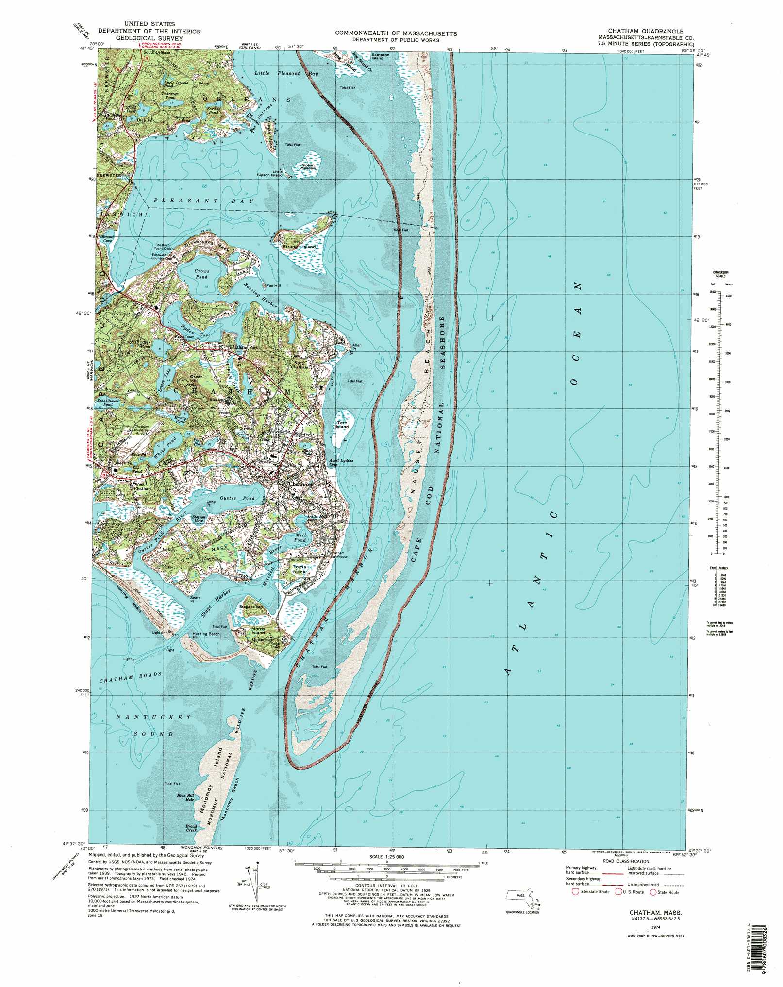
USGS Topo Quad 41069f8 - 1:25,000 scale
| Topo Map Name: | Chatham |
| USGS Topo Quad ID: | 41069f8 |
| Print Size: | ca. 21 1/4" wide x 27" high |
| Southeast Coordinates: | 41.625° N latitude / 69.875° W longitude |
| Map Center Coordinates: | 41.6875° N latitude / 69.9375° W longitude |
| U.S. State: | MA |
| Filename: | l41069f8.jpg |
| Download Map JPG Image: | Chatham topo map 1:25,000 scale |
| Map Type: | Topographic |
| Topo Series: | 7.5´ |
| Map Scale: | 1:25,000 |
| Source of Map Images: | United States Geological Survey (USGS) |
| Alternate Map Versions: |
Chatham MA 1974, updated 1978 Download PDF Buy paper map Chatham MA 1974, updated 1978 Download PDF Buy paper map Chatham MA 1974, updated 1978 Download PDF Buy paper map Chatham MA 1977, updated 1981 Download PDF Buy paper map |
1:24,000 Topo Quads surrounding Chatham
Wellfleet |
||||
Orleans |
||||
Dennis |
Harwich |
Chatham |
||
Monomoy Point |
||||
> Back to 41069e1 at 1:100,000 scale
> Back to 41068a1 at 1:250,000 scale
> Back to U.S. Topo Maps home
Chatham topo map: Gazetteer
Chatham: Airports
Chatham Municipal Airport elevation 19m 62′North Chatham Heliport elevation 0m 0′
Chatham: Bars
Chatham Bar elevation 0m 0′Chatham: Bays
Aunt Lydias Cove elevation 0m 0′Blue Bill Hole elevation 1m 3′
Broad Creek elevation 1m 3′
Broad Creek elevation -1m -4′
Crows Pond elevation 5m 16′
Pleasant Bay elevation 0m 0′
Quanset Pond elevation -12m -40′
Round Cove elevation 1m 3′
Ryder Cove elevation 1m 3′
Stetson Cove elevation 0m 0′
Chatham: Beaches
Harding Beach elevation 3m 9′Monomoy Beach elevation 0m 0′
Oyster Pond Beach elevation 0m 0′
Chatham: Capes
Allen Point elevation 5m 16′Amos Point elevation 1m 3′
Avalon Point elevation 7m 22′
Eastward Point elevation 3m 9′
Eldridge Point elevation 4m 13′
Harding Beach Point elevation 1m 3′
Long Point elevation 0m 0′
Morris Island elevation 11m 36′
Nickersons Neck elevation 4m 13′
Sears Point elevation 0m 0′
Stage Island elevation 2m 6′
The Neck elevation 5m 16′
Toms Neck elevation 3m 9′
Chatham: Flats
Common Flat elevation 0m 0′Sipson Meadow elevation 1m 3′
Chatham: Guts
Broad Creek elevation 0m 0′The Narrows elevation 0m 0′
Chatham: Harbors
Bassing Harbor elevation 1m 3′Chatham Harbor elevation 0m 0′
Chatham Inner Harbor elevation 0m 0′
Chatham Roads elevation 0m 0′
Stage Harbor elevation 0m 0′
Chatham: Islands
Fox Hill elevation 6m 19′Hog Island elevation 2m 6′
Little Sipson Island elevation 3m 9′
North Monomoy Island elevation 1m 3′
Sipson Island elevation 10m 32′
Strong Island elevation 2m 6′
Tern Island elevation 1m 3′
Chatham: Lakes
Bear Pond elevation 6m 19′Black Pond elevation 6m 19′
Black Pond elevation 7m 22′
Blue Pond elevation 7m 22′
Deep Pond elevation 8m 26′
Emery Pond elevation 3m 9′
Little Mill Pond elevation 0m 0′
Lovers Lake elevation 3m 9′
Mill Pond elevation 0m 0′
Oyster Pond elevation 0m 0′
Perch Pond elevation 6m 19′
Sarahs Pond elevation 4m 13′
Schoolhouse Pond elevation 3m 9′
Shoal Pond elevation 3m 9′
Stillwater Pond elevation 0m 0′
Uncle Israels Pond elevation 5m 16′
Uncle Seths Pond elevation 7m 22′
White Pond elevation 3m 9′
Chatham: Parks
Cape Cod National Seashore elevation 0m 0′Tern Island Sanctuary elevation 1m 3′
Chatham: Populated Places
Chatham elevation 4m 13′Chatham Port elevation 0m 0′
North Chatham elevation 12m 39′
Quitnesset elevation 9m 29′
West Chatham elevation 15m 49′
Chatham: Streams
Frost Fish Creek elevation 0m 0′Mitchell River elevation 0m 0′
Muddy Creek elevation 11m 36′
Oyster Pond River elevation 0m 0′
Chatham: Summits
Cannon Hill elevation 5m 16′Great Hill elevation 38m 124′
Indian Fort Hill elevation 0m 0′
Nauset Beach Dunes elevation 1m 3′
Watch Hill elevation 6m 19′
Chatham: Swamps
Mitchell River Marshes elevation 0m 0′Morris Island Marshes elevation 3m 9′
Oyster Pond River Marshes elevation 3m 9′
Strong Island Marshes elevation 2m 6′
Chatham digital topo map on disk
Buy this Chatham topo map showing relief, roads, GPS coordinates and other geographical features, as a high-resolution digital map file on DVD:
Maine, New Hampshire, Rhode Island & Eastern Massachusetts
Buy digital topo maps: Maine, New Hampshire, Rhode Island & Eastern Massachusetts