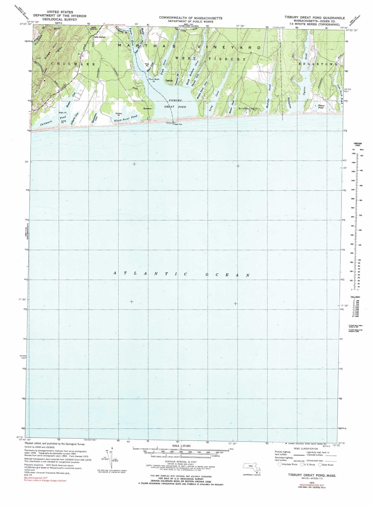
Tisbury Great Pond Topo Map Massachusetts
To zoom in, hover over the map of Tisbury Great Pond
USGS Topo Quad 41070c5 - 1:25,000 scale
| Topo Map Name: | Tisbury Great Pond |
| USGS Topo Quad ID: | 41070c5 |
| Print Size: | ca. 21 1/4" wide x 27" high |
| Southeast Coordinates: | 41.25° N latitude / 70.5° W longitude |
| Map Center Coordinates: | 41.3125° N latitude / 70.5625° W longitude |
| U.S. State: | MA |
| Filename: | l41070c5.jpg |
| Download Map JPG Image: | Tisbury Great Pond topo map 1:25,000 scale |
| Map Type: | Topographic |
| Topo Series: | 7.5´ |
| Map Scale: | 1:25,000 |
| Source of Map Images: | United States Geological Survey (USGS) |
| Alternate Map Versions: |
1:24,000 Topo Quads surrounding Tisbury Great Pond
Sconticut Neck |
Woods Hole |
Falmouth |
Cotuit |
Hyannis |
Cuttyhunk |
Nauson Island |
Vineyard Haven |
||
Squibnocket |
Tisbury Great Pond |
Edgartown |
||
> Back to 41070a1 at 1:100,000 scale
> Back to 41070a1 at 1:250,000 scale
> Back to U.S. Topo Maps home
Tisbury Great Pond topo map: Gazetteer
Tisbury Great Pond: Airports
Katama Air Park elevation 3m 9′Katama Airpark elevation 4m 13′
Tisbury Great Pond: Bays
Janes Cove elevation 1m 3′Jobs Neck Cove elevation 1m 3′
Lyles Bay elevation 1m 3′
Mashacket Cove elevation 1m 3′
Mattakeset Bay elevation 1m 3′
Ripley Cove elevation -6m -20′
Slough Cove elevation 1m 3′
Turkeyland Cove elevation 1m 3′
Tisbury Great Pond: Beaches
Katama County Beach elevation 0m 0′South Beach elevation 0m 0′
Tisbury Great Pond: Canals
Mattakeset Herring Creek elevation 1m 3′Tisbury Great Pond: Capes
Bluefish Point elevation 1m 3′Bold Water Point elevation 1m 3′
Butler Neck elevation 0m 0′
Butler Neck Point elevation 1m 3′
Kanomika Neck elevation 1m 3′
Katama Neck elevation 1m 3′
King Point elevation 1m 3′
Mashacket Neck elevation 3m 9′
Poketapaces Neck elevation 0m 0′
Quohog Point elevation -6m -20′
Scrubby Neck elevation -7m -23′
Swan Neck elevation 1m 3′
Swan Neck Point elevation 1m 3′
Swimming Place Point elevation 0m 0′
West Point elevation 1m 3′
Tisbury Great Pond: Isthmuses
Jobs Neck elevation 2m 6′Tisbury Great Pond: Lakes
Crackatuxet Cove elevation -10m -33′Edgartown Great Pond elevation 1m 3′
Fresh Pond elevation 1m 3′
Jacobs Pond elevation 1m 3′
Jobs Neck Pond elevation 1m 3′
Oyster Pond elevation -6m -20′
Paqua Pond elevation 1m 3′
Watcha Pond elevation 1m 3′
Tisbury Great Pond: Parks
Long Point Wildlife Refuge elevation 1m 3′Tisbury Great Pond: Populated Places
Katama elevation 4m 13′Tisbury Great Pond digital topo map on disk
Buy this Tisbury Great Pond topo map showing relief, roads, GPS coordinates and other geographical features, as a high-resolution digital map file on DVD:
Maine, New Hampshire, Rhode Island & Eastern Massachusetts
Buy digital topo maps: Maine, New Hampshire, Rhode Island & Eastern Massachusetts