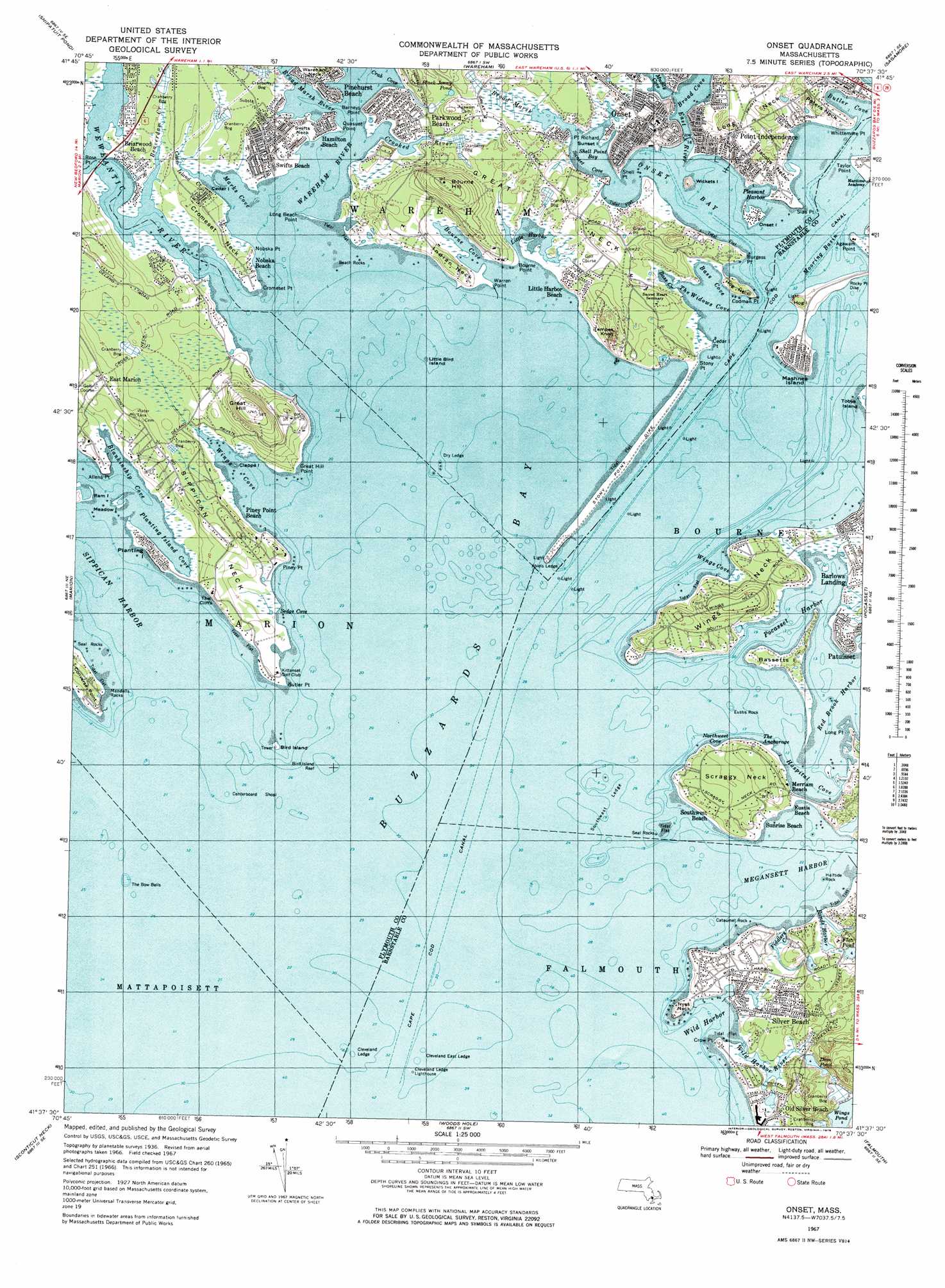
Onset Topo Map Massachusetts
To zoom in, hover over the map of Onset
USGS Topo Quad 41070f6 - 1:25,000 scale
| Topo Map Name: | Onset |
| USGS Topo Quad ID: | 41070f6 |
| Print Size: | ca. 21 1/4" wide x 27" high |
| Southeast Coordinates: | 41.625° N latitude / 70.625° W longitude |
| Map Center Coordinates: | 41.6875° N latitude / 70.6875° W longitude |
| U.S. State: | MA |
| Filename: | l41070f6.jpg |
| Download Map JPG Image: | Onset topo map 1:25,000 scale |
| Map Type: | Topographic |
| Topo Series: | 7.5´ |
| Map Scale: | 1:25,000 |
| Source of Map Images: | United States Geological Survey (USGS) |
| Alternate Map Versions: |
Onset MA 1967, updated 1978 Download PDF Buy paper map Onset MA 1967, updated 1978 Download PDF Buy paper map Onset MA 1977, updated 1981 Download PDF Buy paper map |
1:24,000 Topo Quads surrounding Onset
Bridgewater |
Plympton |
Plymouth |
Manomet |
|
Assawompset Pond |
Snipatuit Pond |
Wareham |
Sagamore |
|
New Bedford North |
Marion |
Onset |
Pocasset |
Sandwich |
New Bedford South |
Sconticut Neck |
Woods Hole |
Falmouth |
Cotuit |
Cuttyhunk |
Nauson Island |
Vineyard Haven |
> Back to 41070e1 at 1:100,000 scale
> Back to 41070a1 at 1:250,000 scale
> Back to U.S. Topo Maps home
Onset topo map: Gazetteer
Onset: Bars
Beach Rocks elevation 0m 0′Bird Island Reef elevation 0m 0′
Bird Island South Shoal elevation 0m 0′
Centerboard Shoal elevation 0m 0′
Cromeset Ledge elevation 0m 0′
Dry Ledge elevation 0m 0′
Gibbs Rock elevation 0m 0′
Mendells Rocks elevation 0m 0′
Quahog Bar elevation 0m 0′
Seal Rocks elevation 0m 0′
Seal Rocks elevation 0m 0′
Stony Point Dike elevation 1m 3′
The Bow Bells elevation 0m 0′
Onset: Basins
Rands Harbor elevation 0m 0′Onset: Bays
Bass Cove elevation 0m 0′Bass Creek elevation 0m 0′
Blankinship Cove elevation 1m 3′
Bourne Cove elevation 0m 0′
Broad Cove elevation 0m 0′
Butler Cove elevation 5m 16′
Crab Cove elevation 0m 0′
Fiddlers Cove elevation 0m 0′
Hospital Cove elevation 0m 0′
Marks Cove elevation 0m 0′
Megansett Harbor elevation 0m 0′
Northwest Cove elevation 0m 0′
Onset Bay elevation 0m 0′
Planting Island Cove elevation 0m 0′
Sedge Cove elevation -3m -10′
Shell Point Bay elevation 0m 0′
Sunset Cove elevation 0m 0′
The Anchorage elevation 0m 0′
The Widows Cove elevation 0m 0′
Wings Cove elevation 0m 0′
Wings Cove elevation 0m 0′
Onset: Beaches
Eustis Beach elevation 1m 3′Little Harbor Beach elevation 0m 0′
Merriam Beach elevation 6m 19′
Nobska Beach elevation 9m 29′
Parkwood Beach elevation 3m 9′
Southwest Beach elevation 2m 6′
Sunrise Beach elevation 6m 19′
Onset: Capes
Agawam Point elevation 0m 0′Allens Point elevation 0m 0′
Barneys Point elevation 0m 0′
Bourne Point elevation 2m 6′
Burgess Point elevation 2m 6′
Butler Point elevation -1m -4′
Cedar Island Point elevation 2m 6′
Charles Neck Point elevation 0m 0′
Codman Point elevation 4m 13′
Converse Point elevation 6m 19′
Cromeset Neck elevation 0m 0′
Cromeset Point elevation 0m 0′
Crow Point elevation 2m 6′
Great Hill Point elevation 5m 16′
Great Neck elevation 13m 42′
Great Neck elevation 5m 16′
Hog Neck elevation 11m 36′
Indian Neck elevation 0m 0′
Jacobs Neck elevation 4m 13′
Long Beach Point elevation 0m 0′
Long Neck elevation 11m 36′
Long Point elevation 2m 6′
Nobska Point elevation 0m 0′
Nyes Neck elevation 2m 6′
Peters Neck elevation 0m 0′
Piney Point elevation 0m 0′
Planting Island elevation 1m 3′
Point Richard elevation 9m 29′
Quasuet Point elevation 0m 0′
Rose Point elevation 0m 0′
Scraggy Neck elevation 9m 29′
Shell Point elevation 0m 0′
Sias Point elevation 0m 0′
Sippican Neck elevation 3m 9′
Stony Point elevation 2m 6′
Sunset Island elevation 0m 0′
Swifts Neck elevation 1m 3′
Wareham Neck elevation 0m 0′
Warren Point elevation 1m 3′
Warren Point elevation 2m 6′
Whittemore Point elevation 4m 13′
Wings Neck elevation 11m 36′
Onset: Channels
Cleveland Ledge Channel elevation 0m 0′Cleveland Ledge Channel elevation 0m 0′
East River elevation 0m 0′
Hog Island Channel elevation 0m 0′
Onset: Cliffs
Hog Island elevation 0m 0′The Cliffs elevation 5m 16′
Onset: Guts
Pocasset Harbor elevation 0m 0′Onset: Harbors
Little Harbor elevation 0m 0′Phinneys Harbor elevation 0m 0′
Pleasant Harbor elevation 0m 0′
Red Brook Harbor elevation 0m 0′
Silver Beach Harbor elevation 2m 6′
Sippican Harbor elevation 0m 0′
Wild Harbor elevation 0m 0′
Onset: Islands
Abiels Ledge elevation 5m 16′Bassetts Island elevation 0m 0′
Bird Island elevation 0m 0′
Cataumet Rock elevation 0m 0′
Cedar Island elevation 0m 0′
Clapps Island elevation 0m 0′
Cleveland East Ledge elevation 0m 0′
Cleveland Ledge elevation 0m 0′
Eustis Rock elevation 0m 0′
Half Tide Rock elevation 0m 0′
Little Bird Island elevation 0m 0′
Meadow Island elevation 0m 0′
Onset Island elevation 5m 16′
Southwest Ledge elevation 0m 0′
Wickets Island elevation 5m 16′
Woods Point elevation 0m 0′
Onset: Isthmuses
Mashnee Island elevation 5m 16′Onset: Lakes
Black Jonny Pond elevation 6m 19′Dam Pond elevation 3m 9′
Little College Pond elevation 0m 0′
Little Long Pond elevation 0m 0′
Trout Pond elevation 1m 3′
Wings Pond elevation 3m 9′
Onset: Populated Places
Barlows Landing elevation 3m 9′Briarwood Beach elevation 3m 9′
East Marion elevation 8m 26′
Hamilton Beach elevation 1m 3′
Old Silver Beach elevation 6m 19′
Onset elevation 4m 13′
Parkwood Beach elevation 9m 29′
Patuisset elevation 3m 9′
Pinehurst Beach elevation 4m 13′
Piney Point Beach elevation 0m 0′
Point Independence elevation 9m 29′
Silver Beach elevation 7m 22′
Swifts Beach elevation 5m 16′
Weweantic elevation 5m 16′
Onset: Post Offices
Onset Post Office (historical) elevation 8m 26′Onset: Streams
Beaverdam Creek elevation 1m 3′Broad Marsh River elevation 0m 0′
Cedar Island Creek elevation 0m 0′
Crooked River elevation 0m 0′
Sippican River elevation 0m 0′
Wareham River elevation 0m 0′
Weweantic River elevation 0m 0′
Wild Harbor River elevation 1m 3′
Onset: Summits
Bourne Hill elevation 29m 95′Great Hill elevation 32m 104′
Tempes Knob elevation 24m 78′
Onset: Swamps
Bourne Cove Marshes elevation 0m 0′Broad Marsh elevation 1m 3′
Great Swamp elevation 3m 9′
Little Harbor Marshes elevation 0m 0′
Marks Cove Marshes elevation 0m 0′
Stones Bog elevation 3m 9′
Wings Cove Marshes elevation 0m 0′
Onset digital topo map on disk
Buy this Onset topo map showing relief, roads, GPS coordinates and other geographical features, as a high-resolution digital map file on DVD:
Maine, New Hampshire, Rhode Island & Eastern Massachusetts
Buy digital topo maps: Maine, New Hampshire, Rhode Island & Eastern Massachusetts