Marion Topo Map Massachusetts
To zoom in, hover over the map of Marion
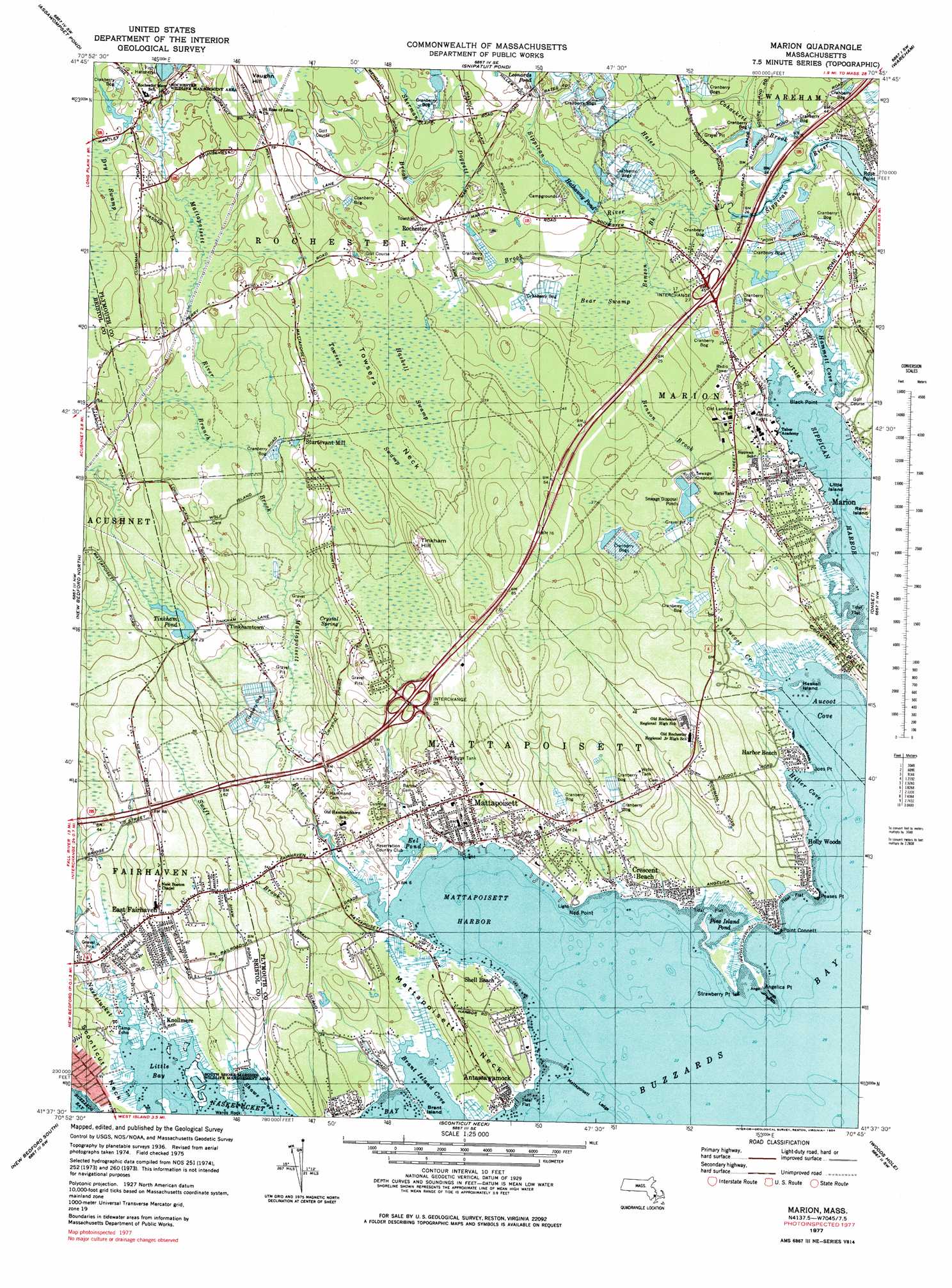
USGS Topo Quad 41070f7 - 1:25,000 scale
| Topo Map Name: | Marion |
| USGS Topo Quad ID: | 41070f7 |
| Print Size: | ca. 21 1/4" wide x 27" high |
| Southeast Coordinates: | 41.625° N latitude / 70.75° W longitude |
| Map Center Coordinates: | 41.6875° N latitude / 70.8125° W longitude |
| U.S. State: | MA |
| Filename: | l41070f7.jpg |
| Download Map JPG Image: | Marion topo map 1:25,000 scale |
| Map Type: | Topographic |
| Topo Series: | 7.5´ |
| Map Scale: | 1:25,000 |
| Source of Map Images: | United States Geological Survey (USGS) |
| Alternate Map Versions: |
Marion MA 1977, updated 1979 Download PDF Buy paper map Marion MA 1977, updated 1981 Download PDF Buy paper map Marion MA 1977, updated 1984 Download PDF Buy paper map Marion MA 1977, updated 1984 Download PDF Buy paper map |
1:24,000 Topo Quads surrounding Marion
Taunton |
Bridgewater |
Plympton |
Plymouth |
Manomet |
Assonet |
Assawompset Pond |
Snipatuit Pond |
Wareham |
Sagamore |
Fall River East |
New Bedford North |
Marion |
Onset |
Pocasset |
Westport |
New Bedford South |
Sconticut Neck |
Woods Hole |
Falmouth |
Sakonnet Point |
Cuttyhunk |
Nauson Island |
Vineyard Haven |
> Back to 41070e1 at 1:100,000 scale
> Back to 41070a1 at 1:250,000 scale
> Back to U.S. Topo Maps home
Marion topo map: Gazetteer
Marion: Bays
Aucoot Cove elevation 0m 0′Brant Island Cove elevation 0m 0′
Briggs Cove elevation -8m -27′
Hammett Cove elevation 0m 0′
Hammonds Cove elevation 0m 0′
Hiller Cove elevation 0m 0′
Little Bay elevation 0m 0′
Mattapoisett Harbor elevation 0m 0′
Molly Cove elevation 0m 0′
Mollys Cove elevation -4m -14′
Nyes Cove elevation 0m 0′
Peckhams Pond elevation 3m 9′
Pine Island Pond elevation 0m 0′
Shaws Cove elevation 0m 0′
Spragues Cove elevation 0m 0′
Marion: Beaches
Brant Beach elevation 0m 0′Grand Vue Beach elevation 2m 6′
Hollywoods Beach elevation 0m 0′
Mattapoisett Town Beach elevation 0m 0′
Pico Beach elevation 0m 0′
Marion: Capes
Angelica Point elevation 0m 0′Black Point elevation 0m 0′
Joes Point elevation 0m 0′
Little Neck elevation 8m 26′
Mattapoisett Neck elevation 10m 32′
Ned Point elevation 1m 3′
Peases Point elevation 0m 0′
Point Connett elevation 0m 0′
Stewart Island elevation 0m 0′
Strawberry Point elevation 0m 0′
Marion: Crossings
Interchange Twenty-five elevation 13m 42′Interchange Twenty-seven elevation 8m 26′
Marion: Dams
Hartley Saw Mill Dam elevation 18m 59′Hathaway Pond Dam elevation 2m 6′
Leonards Pond Dam elevation 7m 22′
Tinkham Pond Dam elevation 7m 22′
Marion: Flats
Bayside Meadows elevation -5m -17′Marion: Islands
Barstow Rock elevation 0m 0′Brant Island elevation 3m 9′
Gallatin Rock elevation 0m 0′
Gravel Island elevation 0m 0′
Gravelly Rock elevation 0m 0′
Haskell Island elevation 0m 0′
Little Island elevation 0m 0′
Mattapoisett Ledge elevation 0m 0′
Pine Island elevation 0m 0′
Ram Island elevation 2m 6′
Randall Rock elevation 0m 0′
Snow Rock elevation 0m 0′
Stewarts Island elevation 2m 6′
Sunken Ledge elevation 0m 0′
Wards Rock elevation 0m 0′
Marion: Lakes
Eel Pond elevation 0m 0′Harley Millpond elevation 16m 52′
Marion: Parks
Camp Echo elevation 0m 0′Charles E Washburn Memorial Park elevation 4m 13′
Mattapoisett Shipyard Park elevation 0m 0′
South Shore Marshes Wildlife Management Area elevation 0m 0′
Marion: Populated Places
Alms House elevation 0m 0′Antassawamock elevation 0m 0′
Cannonville elevation 10m 32′
Crescent Beach elevation 1m 3′
East Fairhaven elevation 18m 59′
Grand Vue elevation 7m 22′
Harbor Beach elevation 1m 3′
Holly Woods elevation 0m 0′
Knollmere elevation 1m 3′
Marion elevation 9m 29′
Mattapoisett elevation 1m 3′
Nasketucket elevation 5m 16′
Rochester elevation 10m 32′
Shell Beach elevation 0m 0′
Sturtevant Mill elevation 13m 42′
Tinkhamtown elevation 10m 32′
Wolf Lake elevation 8m 26′
Marion: Post Offices
Marion Post Office (historical) elevation 6m 19′Mattapoisett Post Office elevation 2m 6′
Mattapoisett Post Office (historical) elevation 15m 49′
Rochester Post Office (historical) elevation 9m 29′
Marion: Reservoirs
Hartley Mill Pond elevation 18m 59′Hathaway Pond elevation 2m 6′
Rounseville Pond elevation 12m 39′
Tinkham Pond elevation 7m 22′
Marion: Springs
Crystal Spring elevation 16m 52′Marion: Streams
Aucoot Creek elevation 0m 0′Benson Brook elevation 1m 3′
Branch Brook elevation 4m 13′
Cohackett Brook elevation 0m 0′
Doggett Brook elevation 7m 22′
Hales Brook elevation 2m 6′
Mattapoisett River elevation 0m 0′
Nasketucket River elevation 0m 0′
Pine Island Brook elevation 1m 3′
Sherman Brook elevation 17m 55′
Swift Brook elevation 0m 0′
Marion: Summits
Tinkham Hill elevation 29m 95′Marion: Swamps
Aucoot Cove Marshes elevation 0m 0′Bear Swamp elevation 5m 16′
Cedar Swamp elevation 22m 72′
Eel Pond Marshes elevation 0m 0′
Haskell Swamp elevation 13m 42′
Hiller Cove Marshes elevation 0m 0′
Little Bear Swamp elevation 14m 45′
Mattapoisett Neck Marshes elevation 0m 0′
Mattapoisett River Marshes elevation 5m 16′
Sippican Bog elevation 8m 26′
Sippican Harbor Marshes elevation 0m 0′
Sippican River Marshes elevation 2m 6′
Towsers Neck elevation 11m 36′
Towsers Swamp elevation 14m 45′
Marion digital topo map on disk
Buy this Marion topo map showing relief, roads, GPS coordinates and other geographical features, as a high-resolution digital map file on DVD:
Maine, New Hampshire, Rhode Island & Eastern Massachusetts
Buy digital topo maps: Maine, New Hampshire, Rhode Island & Eastern Massachusetts