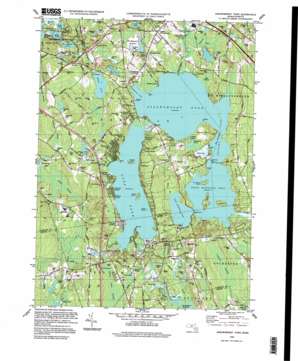
Assawompset Pond Topo Map Massachusetts
To zoom in, hover over the map of Assawompset Pond
USGS Topo Quad 41070g8 - 1:25,000 scale
| Topo Map Name: | Assawompset Pond |
| USGS Topo Quad ID: | 41070g8 |
| Print Size: | ca. 21 1/4" wide x 27" high |
| Southeast Coordinates: | 41.75° N latitude / 70.875° W longitude |
| Map Center Coordinates: | 41.8125° N latitude / 70.9375° W longitude |
| U.S. State: | MA |
| Filename: | l41070g8.jpg |
| Download Map JPG Image: | Assawompset Pond topo map 1:25,000 scale |
| Map Type: | Topographic |
| Topo Series: | 7.5´ |
| Map Scale: | 1:25,000 |
| Source of Map Images: | United States Geological Survey (USGS) |
| Alternate Map Versions: |
Assawompset Pond MA 1978, updated 1979 Download PDF Buy paper map Assawompset Pond MA 1997, updated 1999 Download PDF Buy paper map |
1:24,000 Topo Quads surrounding Assawompset Pond
> Back to 41070e1 at 1:100,000 scale
> Back to 41070a1 at 1:250,000 scale
> Back to U.S. Topo Maps home
Assawompset Pond topo map: Gazetteer
Assawompset Pond: Bays
Barker Cove elevation 16m 52′Sampsons Cove elevation 16m 52′
Assawompset Pond: Capes
Bettys Neck elevation 31m 101′Deans Point elevation 16m 52′
Green Point elevation 16m 52′
Hemlock Point elevation 16m 52′
Jeremys Point elevation 16m 52′
Long Point elevation 20m 65′
Willow Point elevation 17m 55′
Assawompset Pond: Channels
The Narrows elevation 16m 52′Assawompset Pond: Cliffs
King Phillips Lookout elevation 27m 88′White Banks elevation 18m 59′
Assawompset Pond: Crossings
Interchange Eight elevation 29m 95′Interchange Nine elevation 33m 108′
Assawompset Pond: Dams
Big Bearhole Pond Dam elevation 35m 114′Egger Bog Dam elevation 33m 108′
Mill Pond Dam elevation 27m 88′
Pierce Avenue Dam elevation 22m 72′
Saint Yues Bog Dam (historical) elevation 36m 118′
The Reservoir Dam elevation 24m 78′
Assawompset Pond: Islands
Anuxanon Island elevation 16m 52′Goat Island elevation 21m 68′
Great Island elevation 30m 98′
Lewis Island elevation 24m 78′
Little Island elevation 26m 85′
Nelson Island elevation 23m 75′
Assawompset Pond: Lakes
Assawompset Pond elevation 16m 52′Cain Pond elevation 21m 68′
Cedar Pond elevation 27m 88′
Clear Pond elevation 22m 72′
Cranberry Pond elevation 17m 55′
Dunham Pond elevation 17m 55′
Elders Pond elevation 27m 88′
Furnace Pond elevation 10m 32′
Giffords Pond elevation 18m 59′
Great Quittacas Pond elevation 16m 52′
Kings Pond elevation 12m 39′
Little Bearhole Pond elevation 10m 32′
Little Quittacas Pond elevation 16m 52′
Long Pond elevation 16m 52′
Loon Pond elevation 25m 82′
Middle Pond elevation 13m 42′
Pocksha Pond elevation 16m 52′
Assawompset Pond: Parks
Cathedral Camp elevation 17m 55′Assawompset Pond: Populated Places
Ashley Heights elevation 28m 91′Buena Vista Shores elevation 16m 52′
Canedys Corner elevation 33m 108′
Churchill Shores elevation 29m 95′
East Freetown elevation 23m 75′
Fuller Shores elevation 20m 65′
Heaven Heights elevation 27m 88′
Hemlocks elevation 34m 111′
Hilltop Acres elevation 31m 101′
Huckleberry Shores elevation 21m 68′
Indian Shore elevation 16m 52′
Lakeside elevation 16m 52′
Lakeside Shore elevation 33m 108′
Lakeview Heights elevation 30m 98′
Lakeville elevation 27m 88′
Masons Corner elevation 27m 88′
Nelsons Grove elevation 19m 62′
Nelsons Shores elevation 23m 75′
North Lakeville elevation 24m 78′
North Rochester elevation 23m 75′
Pine Bluffs elevation 16m 52′
Pine Haven elevation 19m 62′
Precinct elevation 36m 118′
Sampsons Corner elevation 23m 75′
Staples Corner elevation 27m 88′
Staples Shore elevation 16m 52′
Upper Four Corners elevation 29m 95′
Wayside elevation 24m 78′
Assawompset Pond: Post Offices
Lakeville Post Office elevation 26m 85′North Rochester Post Office (historical) elevation 30m 98′
Assawompset Pond: Reservoirs
Egger Bog Pond elevation 33m 108′Mill Pond elevation 28m 91′
Pierce Avenue Pond elevation 22m 72′
Saint Yues Bog Reservoir elevation 36m 118′
The Reservoir elevation 24m 78′
Assawompset Pond: Streams
Ashley Brook elevation 14m 45′Bates Brook elevation 16m 52′
Black Brook elevation 16m 52′
Fall Brook elevation 15m 49′
Fall Brook elevation 16m 52′
Hathaway Brook elevation 16m 52′
Long Pond River elevation 16m 52′
Shaving Brook elevation 17m 55′
Spring Brook elevation 16m 52′
Spring Brook elevation 9m 29′
Stony Brook elevation 20m 65′
Tamett Brook elevation 21m 68′
Assawompset Pond: Summits
Alden Hill elevation 33m 108′Braley Hill elevation 44m 144′
Burial Hill elevation 26m 85′
Le Baron Hill elevation 32m 104′
Miller Hill elevation 40m 131′
Pickens Hill elevation 40m 131′
Pigeon Hill elevation 55m 180′
Shockley Hill elevation 56m 183′
Tinkham Hill elevation 64m 209′
Williams Hill elevation 44m 144′
Willis Hill elevation 30m 98′
Assawompset Pond: Swamps
Bolton Cedar Swamp elevation 24m 78′Casual Swamp elevation 28m 91′
Logging Swamp elevation 21m 68′
Owl Swamp elevation 23m 75′
Assawompset Pond digital topo map on disk
Buy this Assawompset Pond topo map showing relief, roads, GPS coordinates and other geographical features, as a high-resolution digital map file on DVD:
Maine, New Hampshire, Rhode Island & Eastern Massachusetts
Buy digital topo maps: Maine, New Hampshire, Rhode Island & Eastern Massachusetts


