Montauk Point Topo Map New York
To zoom in, hover over the map of Montauk Point
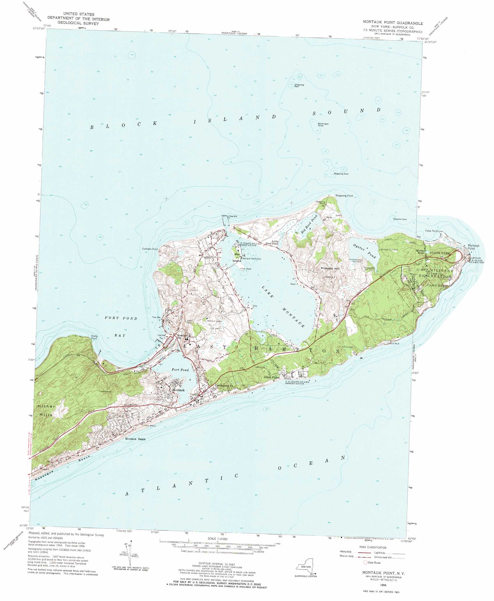
USGS Topo Quad 41071a8 - 1:24,000 scale
| Topo Map Name: | Montauk Point |
| USGS Topo Quad ID: | 41071a8 |
| Print Size: | ca. 21 1/4" wide x 27" high |
| Southeast Coordinates: | 41° N latitude / 71.875° W longitude |
| Map Center Coordinates: | 41.0625° N latitude / 71.9375° W longitude |
| U.S. State: | NY |
| Filename: | o41071a8.jpg |
| Download Map JPG Image: | Montauk Point topo map 1:24,000 scale |
| Map Type: | Topographic |
| Topo Series: | 7.5´ |
| Map Scale: | 1:24,000 |
| Source of Map Images: | United States Geological Survey (USGS) |
| Alternate Map Versions: |
Montauk Point NY 1942 Download PDF Buy paper map Montauk Point NY 1956, updated 1957 Download PDF Buy paper map Montauk Point NY 1956, updated 1965 Download PDF Buy paper map Montauk Point NY 2010 Download PDF Buy paper map Montauk Point NY 2013 Download PDF Buy paper map Montauk Point NY 2016 Download PDF Buy paper map |
1:24,000 Topo Quads surrounding Montauk Point
Niantic |
New London |
Mystic |
Watch Hill |
Quonochontaug |
Plum Island |
||||
Gardiners Island West |
Gardiners Island East |
Montauk Point |
||
East Hampton |
Napeague Beach |
|||
> Back to 41071a1 at 1:100,000 scale
> Back to 41070a1 at 1:250,000 scale
> Back to U.S. Topo Maps home
Montauk Point topo map: Gazetteer
Montauk Point: Airports
Montauk Airport elevation 1m 3′Montauk Seaplane Base elevation 0m 0′
Montauk Point: Bars
Blackfish Rock elevation 0m 0′Shagwong Reef elevation 0m 0′
Shagwong Rock elevation 0m 0′
Washington Shoal elevation 0m 0′
Montauk Point: Bays
Fort Pond Bay elevation 0m 0′Montauk Harbor elevation 0m 0′
Montauk Point: Capes
Culloden Point elevation 14m 45′Rocky Point elevation 11m 36′
Shagwong Point elevation 1m 3′
Montauk Point: Islands
Star Island elevation 2m 6′Montauk Point: Lakes
Big Reed Pond elevation 1m 3′Fort Pond elevation 1m 3′
Lake Montauk elevation 0m 0′
Little Reed Pond elevation 1m 3′
Oyster Pond elevation 1m 3′
Montauk Point: Parks
Hither Woods Preserve elevation 25m 82′Lee Koppelman Nature Preserve elevation 46m 150′
Montauk County Park elevation 18m 59′
Montauk Downs State Park elevation 17m 55′
Montauk Point State Park elevation 15m 49′
Montauk Point: Populated Places
Ditch Plains elevation 3m 9′Montauk elevation 10m 32′
Montauk Beach elevation 20m 65′
Montauk Station elevation 3m 9′
Montauk Point: Post Offices
Perry B Duryea Junior Post Office elevation 6m 19′Montauk Point: Summits
Hither Hills elevation 26m 85′Prospect Hill elevation 47m 154′
Montauk Point digital topo map on disk
Buy this Montauk Point topo map showing relief, roads, GPS coordinates and other geographical features, as a high-resolution digital map file on DVD:
Maine, New Hampshire, Rhode Island & Eastern Massachusetts
Buy digital topo maps: Maine, New Hampshire, Rhode Island & Eastern Massachusetts