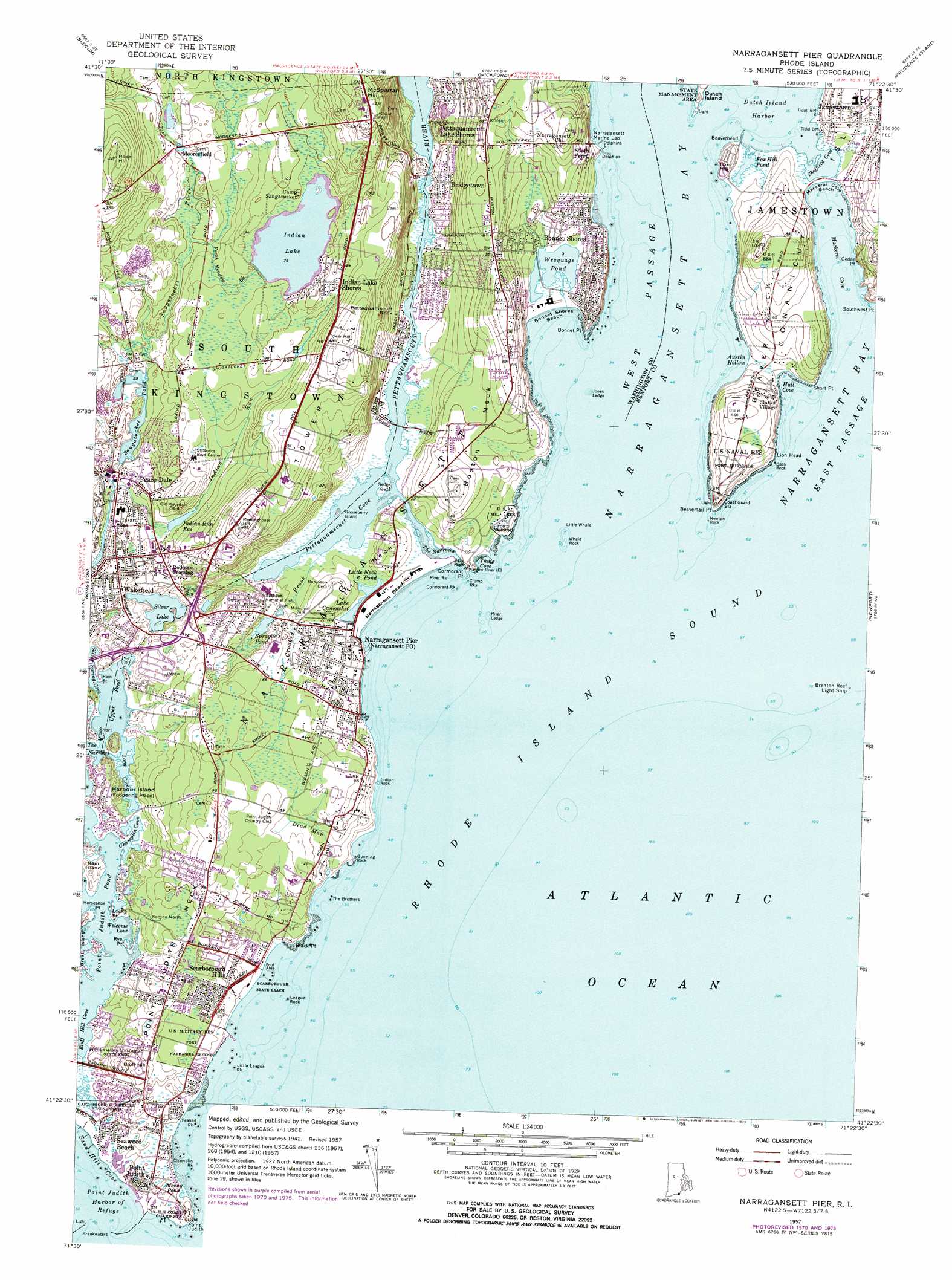
Narragansett Pier Topo Map Rhode Island
To zoom in, hover over the map of Narragansett Pier
USGS Topo Quad 41071d4 - 1:24,000 scale
| Topo Map Name: | Narragansett Pier |
| USGS Topo Quad ID: | 41071d4 |
| Print Size: | ca. 21 1/4" wide x 27" high |
| Southeast Coordinates: | 41.375° N latitude / 71.375° W longitude |
| Map Center Coordinates: | 41.4375° N latitude / 71.4375° W longitude |
| U.S. State: | RI |
| Filename: | o41071d4.jpg |
| Download Map JPG Image: | Narragansett Pier topo map 1:24,000 scale |
| Map Type: | Topographic |
| Topo Series: | 7.5´ |
| Map Scale: | 1:24,000 |
| Source of Map Images: | United States Geological Survey (USGS) |
| Alternate Map Versions: |
Narragansett Pier RI 1942, updated 1957 Download PDF Buy paper map Narragansett Pier RI 1957, updated 1959 Download PDF Buy paper map Narragansett Pier RI 1957, updated 1965 Download PDF Buy paper map Narragansett Pier RI 1957, updated 1973 Download PDF Buy paper map Narragansett Pier RI 1957, updated 1976 Download PDF Buy paper map Narragansett Pier RI 1957, updated 1976 Download PDF Buy paper map Narragansett Pier RI 2012 Download PDF Buy paper map Narragansett Pier RI 2015 Download PDF Buy paper map |
1:24,000 Topo Quads surrounding Narragansett Pier
Coventry Center |
Crompton |
East Greenwich |
Bristol |
|
Hope Valley |
Slocum |
Wickford |
Prudence Island |
|
Carolina |
Kingston |
Narragansett Pier |
Newport |
|
Quonochontaug |
||||
Block Island |
> Back to 41071a1 at 1:100,000 scale
> Back to 41070a1 at 1:250,000 scale
> Back to U.S. Topo Maps home
Narragansett Pier topo map: Gazetteer
Narragansett Pier: Airports
South County Hospital Airport elevation 17m 55′Narragansett Pier: Bars
Bass Rock elevation 2m 6′Dickens Reef elevation 0m 0′
Old Antgonio elevation 0m 0′
Narragansett Pier: Bays
Boiling Lot Cove elevation 0m 0′Champlin Cove (historical) elevation 0m 0′
Dutch Island Harbor elevation -3m -10′
Hull Cove elevation -3m -10′
Long Cove elevation 2m 6′
Mackerel Cove elevation 0m 0′
Pettaquamscutt Cove elevation 0m 0′
River Ledge elevation 0m 0′
Sheffield Cove elevation 0m 0′
Silver Spring Cove elevation 3m 9′
Thule Cove elevation 0m 0′
Welcome Cove elevation 4m 13′
Wheatfield Cove elevation 0m 0′
Narragansett Pier: Beaches
Bonnet Shores Beach elevation 0m 0′Conochet Club Beach elevation 1m 3′
Dunes Club Beach elevation 0m 0′
Mackeral Cove Beach elevation 0m 0′
Scarborough South State Beach elevation 1m 3′
Scarborough State Beach elevation 4m 13′
Narragansett Pier: Benches
Jones Ledge elevation 0m 0′Narragansett Pier: Capes
Beaverhead elevation -3m -10′Beavertail Point elevation 1m 3′
Black Point elevation 0m 0′
Bonnet Point elevation 1m 3′
Boston Neck elevation 15m 49′
Cedar Point elevation 5m 16′
Cedar Point elevation 0m 0′
Cormorant Point elevation 2m 6′
Frank Point elevation 3m 9′
Horseshoe Point elevation 0m 0′
Little Neck elevation 9m 29′
Locke Point elevation 4m 13′
Pickerel Point elevation 12m 39′
Point Judith Neck elevation 12m 39′
Ram Point elevation 1m 3′
Rye Point elevation 0m 0′
Short Point elevation 1m 3′
Short Point elevation 0m 0′
Southwest Point elevation 7m 22′
The Bonnet elevation 14m 45′
Narragansett Pier: Channels
Judith Pond elevation 0m 0′Narragansett Pier: Cliffs
Lion Head elevation 4m 13′Narragansett Pier: Dams
Indian Lake Dam elevation 24m 78′Peace Dale Pond Dam elevation 15m 49′
Narragansett Pier: Guts
The Narrows elevation 0m 0′The Narrows elevation 0m 0′
Narragansett Pier: Islands
Goose Island elevation 0m 0′Gooseberry Island elevation 0m 0′
Harbour Island elevation 7m 22′
Ram Island elevation 1m 3′
Narragansett Pier: Lakes
Fox Hill Pond elevation -3m -10′Indian Lake elevation 24m 78′
Lake Canonchet elevation 1m 3′
Little Neck Pond elevation 1m 3′
Saugatucket Pond elevation 12m 39′
Silver Lake elevation 20m 65′
Sprague Pond elevation 22m 72′
Upper Pond elevation 0m 0′
Wesquage Pond elevation -3m -10′
Narragansett Pier: Mines
Cojoot Mine (historical) elevation 17m 55′Narragansett Pier: Parks
Adventureland Amusement Park elevation 26m 85′Artillery Park elevation 10m 32′
Canochet Memorial elevation 4m 13′
Central Street Historic District elevation 15m 49′
Daughters of the American Revolution Memorial elevation 25m 82′
Earlscourt Historic District elevation 12m 39′
Fishermans Memorial State Park elevation 14m 45′
Narragansett Indian Monument elevation 17m 55′
Ocean Road Historic District elevation 15m 49′
Old Mountain Field elevation 26m 85′
Pettaquamscutt Park elevation 4m 13′
Sprague Memorial Field elevation 14m 45′
Sprague Park elevation 15m 49′
Towers Historic District elevation 7m 22′
Narragansett Pier: Pillars
Bass Rock elevation 9m 29′Beach Rock elevation 0m 0′
Black Point Rock elevation 0m 0′
Bog Rock elevation 5m 16′
Clump Rocks elevation 0m 0′
Cormorant Rock elevation 0m 0′
Flat Rock elevation 6m 19′
Flat Rock elevation 23m 75′
Gunning Rock elevation 0m 0′
Indian Rock elevation 2m 6′
League Rock elevation 0m 0′
Little League Rock elevation 0m 0′
Little Whale elevation 0m 0′
Newton Rock elevation -3m -10′
Pettaquamscutt Rock elevation 39m 127′
River Rock elevation 0m 0′
The Brothers elevation 0m 0′
Whale Rock elevation 0m 0′
Narragansett Pier: Populated Places
Bonnet Shores elevation 2m 6′Bridgetown elevation 4m 13′
Clarks Village elevation 10m 32′
Indian Lake Shores elevation 35m 114′
Mooresfield elevation 18m 59′
Narragansett elevation 6m 19′
Narragansett Beach elevation 1m 3′
Narragansett Pier elevation 1m 3′
Peace Dale elevation 11m 36′
Pettaquamscutt Lake Shores elevation 1m 3′
Rodman Crossing (historical) elevation 25m 82′
Scarborough Hills elevation 7m 22′
South Ferry elevation 10m 32′
Tower Hill (historical) elevation 50m 164′
Whale Rock Light (historical) elevation 0m 0′
Narragansett Pier: Post Offices
Jamestown Post Office elevation 10m 32′Narragansett Post Office elevation 1m 3′
Narragansett Pier: Reservoirs
Indian Run Reservoir elevation 14m 45′Narragansett Pier: Springs
Gin Spring elevation 11m 36′Narragansett Pier: Streams
Aguntang Brook elevation 0m 0′Crooked Brook elevation 0m 0′
Dead Man Brook elevation 4m 13′
Fresh Meadow Brook elevation 14m 45′
Indian Run elevation 8m 26′
Pettaquamscutt River elevation 11m 36′
Saugatucket River elevation 26m 85′
Narragansett Pier: Summits
Big White Hill elevation 6m 19′Bluff Hill elevation 14m 45′
Fox Hill elevation 7m 22′
McSparran Hill elevation 70m 229′
Meetinghouse Hill elevation 57m 187′
Rose Hill elevation 63m 206′
Tower Hill elevation 49m 160′
Narragansett Pier: Swamps
Crying Bog elevation 21m 68′Narragansett Pier: Valleys
Austin Hollow elevation -3m -10′Narragansett Pier digital topo map on disk
Buy this Narragansett Pier topo map showing relief, roads, GPS coordinates and other geographical features, as a high-resolution digital map file on DVD:
Maine, New Hampshire, Rhode Island & Eastern Massachusetts
Buy digital topo maps: Maine, New Hampshire, Rhode Island & Eastern Massachusetts