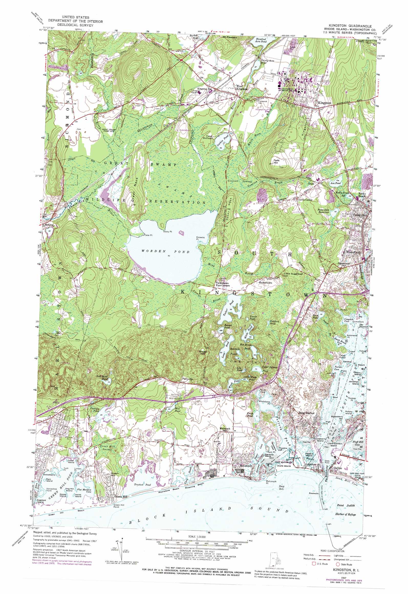
Kingston Topo Map Rhode Island
To zoom in, hover over the map of Kingston
USGS Topo Quad 41071d5 - 1:24,000 scale
| Topo Map Name: | Kingston |
| USGS Topo Quad ID: | 41071d5 |
| Print Size: | ca. 21 1/4" wide x 27" high |
| Southeast Coordinates: | 41.375° N latitude / 71.5° W longitude |
| Map Center Coordinates: | 41.4375° N latitude / 71.5625° W longitude |
| U.S. State: | RI |
| Filename: | o41071d5.jpg |
| Download Map JPG Image: | Kingston topo map 1:24,000 scale |
| Map Type: | Topographic |
| Topo Series: | 7.5´ |
| Map Scale: | 1:24,000 |
| Source of Map Images: | United States Geological Survey (USGS) |
| Alternate Map Versions: |
Kingston RI 2012 Download PDF Buy paper map Kingston RI 2015 Download PDF Buy paper map |
1:24,000 Topo Quads surrounding Kingston
Oneco |
Coventry Center |
Crompton |
East Greenwich |
Bristol |
Voluntown |
Hope Valley |
Slocum |
Wickford |
Prudence Island |
Ashaway |
Carolina |
Kingston |
Narragansett Pier |
Newport |
Watch Hill |
Quonochontaug |
|||
Block Island |
> Back to 41071a1 at 1:100,000 scale
> Back to 41070a1 at 1:250,000 scale
> Back to U.S. Topo Maps home
Kingston topo map: Gazetteer
Kingston: Airports
Richmond Airport elevation 36m 118′Kingston: Bays
Billington Cove elevation 1m 3′Bluff Hill Cove elevation 0m 0′
Congdon Cove elevation 0m 0′
Galilee Salt Pond Harbor elevation 0m 0′
Perch Cove elevation 1m 3′
Seaweed Cove elevation 2m 6′
Segar Cove elevation 2m 6′
Smelt Brook Cove elevation 0m 0′
South Jerry Cove elevation 3m 9′
Stallion Cove elevation 0m 0′
Sycamore Cove elevation 2m 6′
The Pots elevation 3m 9′
Turner Cove elevation 0m 0′
Kingston: Beaches
East Matunuck State Beach elevation 0m 0′Salty Brine State Beach elevation 1m 3′
Sand Hill Cove State Beach elevation 3m 9′
Kingston: Capes
Betty Hull Point elevation 0m 0′Buttonwood Point elevation 0m 0′
Case Point elevation 27m 88′
Crown Point elevation 0m 0′
Knowles Point elevation 27m 88′
Meadow Point elevation 2m 6′
Pine Tree Point elevation 0m 0′
Ram Point elevation 2m 6′
Reel Point elevation 0m 0′
Squally Point elevation 2m 6′
Stony Point elevation 27m 88′
Succotash Point elevation 1m 3′
Thomas Point elevation 0m 0′
Toby Point elevation 0m 0′
Turner Point elevation 7m 22′
Whaleboat Point elevation 2m 6′
Kingston: Dams
Great Swamp Goose Marsh Dam elevation 28m 91′Kingston: Guts
The Breachway elevation 1m 3′Kingston: Islands
Albro Island elevation 0m 0′Beach Island elevation 0m 0′
Beef Island elevation 0m 0′
Bill Island elevation 0m 0′
Bush Island elevation 0m 0′
Cedar Island elevation 0m 0′
Cedar Island elevation 0m 0′
Cummock Island elevation 0m 0′
Gardner Island elevation 0m 0′
Gardner Island elevation 2m 6′
Gooseberry Island elevation 0m 0′
Great Island elevation 7m 22′
Hazard Island elevation 2m 6′
Jonathan Island elevation 3m 9′
Little Comfort Island elevation 1m 3′
Plato Island elevation 3m 9′
Potato Island elevation 0m 0′
Kingston: Lakes
Asa Pond elevation 31m 101′Bull Head Pond elevation 21m 68′
Cedar Swamp Pond elevation 21m 68′
Factory Pond elevation 9m 29′
Fresh Pond elevation 1m 3′
Hot House Pond elevation 25m 82′
Larkin Pond elevation 29m 95′
Lily Pond elevation 22m 72′
Little Wash Pond elevation 19m 62′
Long Pond elevation 27m 88′
Maple Lake elevation 28m 91′
Mill Pond elevation 14m 45′
Peddlers Pond elevation 33m 108′
Point Judith Pond elevation 0m 0′
Potter Pond elevation 2m 6′
Round Pond elevation 32m 104′
Rum Pond elevation 7m 22′
Spectacle Ponds elevation 24m 78′
Teal Pond elevation 3m 9′
Thirty Acre Pond elevation 28m 91′
Tucker Pond elevation 29m 95′
Turtle Pond elevation 31m 101′
Wash Pond elevation 19m 62′
White Pond elevation 29m 95′
Worden Pond elevation 27m 88′
Kingston: Parks
Galilee Bird Sanctuary elevation 3m 9′Great Swamp Fight Site elevation 30m 98′
Great Swamp Wildlife Reservation elevation 30m 98′
Kingston Village Historic District elevation 74m 242′
Peace Dale Historic District elevation 9m 29′
South Shore Management Area elevation 9m 29′
Succotash Marsh State Management Area elevation 2m 6′
Truston Pond National Wildlife Refuge elevation 6m 19′
Kingston: Populated Places
Curtis Corner elevation 49m 160′Galilee elevation 2m 6′
Galilee elevation 3m 9′
Gould elevation 42m 137′
Jerusalem elevation 3m 9′
Kingston elevation 75m 246′
Kingston Station elevation 35m 114′
Matunuck elevation 5m 16′
Perryville elevation 26m 85′
Rocky Brook elevation 17m 55′
Snug Harbor elevation 6m 19′
Tuckertown elevation 34m 111′
Tuckertown Four Corners elevation 30m 98′
Wakefield elevation 4m 13′
West Kingston elevation 31m 101′
Kingston: Ranges
The Hills elevation 35m 114′Kingston: Reservoirs
Great Swamp Goose Marsh elevation 28m 91′Peace Dale Reservoir elevation 33m 108′
Rocky Brook Reservoir elevation 23m 75′
Wakefield Mill Reservoir elevation 5m 16′
Kingston: Springs
Dead Man Spring elevation 22m 72′Kingston: Streams
Alewife Brook elevation 30m 98′Browns Brook elevation 11m 36′
Chickasheen Brook elevation 28m 91′
Chipuxet River elevation 27m 88′
Genesee Brook elevation 30m 98′
Mink Brook elevation 27m 88′
Smelt Brook elevation 3m 9′
Usquepaug River elevation 27m 88′
White Horn Brook elevation 30m 98′
Kingston: Summits
Blackberry Hill elevation 20m 65′Broad Hill elevation 58m 190′
Great Neck elevation 39m 127′
Jumping Hill elevation 16m 52′
Kingston Hill elevation 74m 242′
Little Sugarloaf Hill elevation 37m 121′
Strawberry Hill elevation 0m 0′
Sugarloaf Hill elevation 39m 127′
Tefft Hill elevation 78m 255′
Tobey Neck elevation 51m 167′
Kingston: Swamps
Genesee Swamp elevation 29m 95′Great Swamp elevation 30m 98′
Green Hill Swamp elevation 6m 19′
Kingston: Woods
Genesee Woods elevation 34m 111′Kingston digital topo map on disk
Buy this Kingston topo map showing relief, roads, GPS coordinates and other geographical features, as a high-resolution digital map file on DVD:
Maine, New Hampshire, Rhode Island & Eastern Massachusetts
Buy digital topo maps: Maine, New Hampshire, Rhode Island & Eastern Massachusetts