Prudence Island Topo Map Rhode Island
To zoom in, hover over the map of Prudence Island
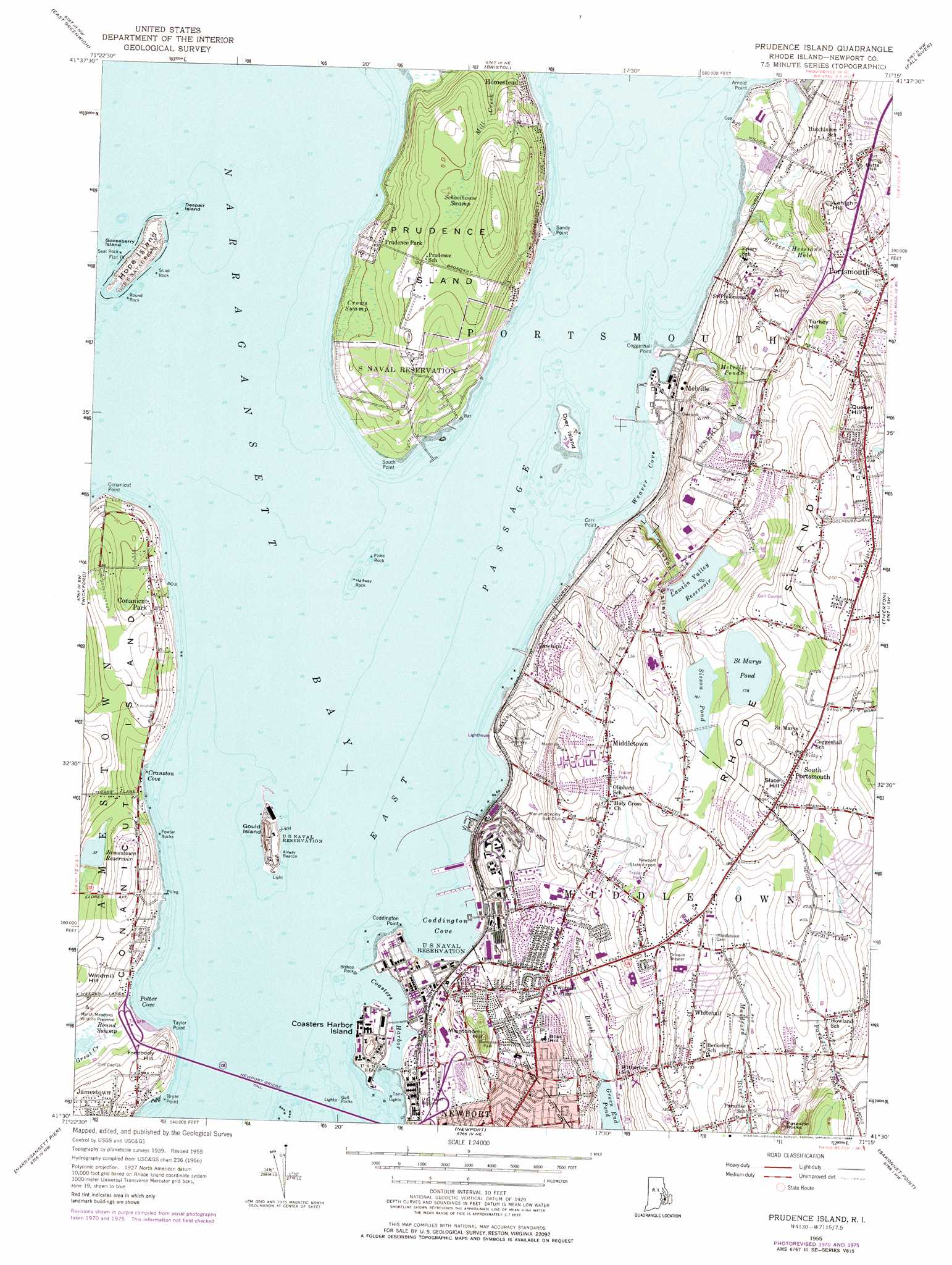
USGS Topo Quad 41071e3 - 1:24,000 scale
| Topo Map Name: | Prudence Island |
| USGS Topo Quad ID: | 41071e3 |
| Print Size: | ca. 21 1/4" wide x 27" high |
| Southeast Coordinates: | 41.5° N latitude / 71.25° W longitude |
| Map Center Coordinates: | 41.5625° N latitude / 71.3125° W longitude |
| U.S. State: | RI |
| Filename: | o41071e3.jpg |
| Download Map JPG Image: | Prudence Island topo map 1:24,000 scale |
| Map Type: | Topographic |
| Topo Series: | 7.5´ |
| Map Scale: | 1:24,000 |
| Source of Map Images: | United States Geological Survey (USGS) |
| Alternate Map Versions: |
Prudence Island RI 1955, updated 1958 Download PDF Buy paper map Prudence Island RI 1955, updated 1965 Download PDF Buy paper map Prudence Island RI 1955, updated 1973 Download PDF Buy paper map Prudence Island RI 1955, updated 1976 Download PDF Buy paper map Prudence Island RI 1955, updated 1984 Download PDF Buy paper map Prudence Island RI 1996, updated 2000 Download PDF Buy paper map Prudence Island RI 2012 Download PDF Buy paper map Prudence Island RI 2015 Download PDF Buy paper map |
1:24,000 Topo Quads surrounding Prudence Island
North Scituate |
East Providence |
Assonet |
||
Crompton |
East Greenwich |
Bristol |
Fall River East |
|
Slocum |
Wickford |
Prudence Island |
Westport |
|
Kingston |
Narragansett Pier |
Newport |
Sakonnet Point |
|
> Back to 41071e1 at 1:100,000 scale
> Back to 41070a1 at 1:250,000 scale
> Back to U.S. Topo Maps home
Prudence Island topo map: Gazetteer
Prudence Island: Airports
Newport Airport (historical) elevation 30m 98′Newport State Airport elevation 53m 173′
Prudence Island: Bays
Bullock Cove elevation 0m 0′Coasters Harbor elevation 0m 0′
Coddington Cove elevation 0m 0′
Cranston Cove elevation 0m 0′
Narragansett Bay elevation 40m 131′
Potter Cove elevation 0m 0′
Weaver Cove elevation 0m 0′
Prudence Island: Bridges
Newport Toll Bridge elevation 0m 0′Prudence Island: Capes
Arnold Point elevation 0m 0′Bryer Point elevation 0m 0′
Carr Point elevation 0m 0′
Coddington Point elevation 0m 0′
Coggeshall Point elevation 1m 3′
Conanicut Point elevation 0m 0′
Flat Point elevation 0m 0′
Sandy Point elevation 0m 0′
South Point elevation 17m 55′
Taylor Point elevation 2m 6′
Prudence Island: Channels
East Passage elevation 0m 0′Prudence Island: Crossings
Interchange 1 elevation 34m 111′Interchange 2 elevation 49m 160′
Prudence Island: Dams
Jamestown Reservoir Dam elevation 11m 36′Lawton Valley Reservoir Dam elevation 37m 121′
Saint Marys Pond Dam elevation 54m 177′
Sisson Pond Dam elevation 49m 160′
Prudence Island: Islands
Coasters Harbor Island elevation 4m 13′Despair Island elevation 0m 0′
Dyer Island elevation 6m 19′
Gooseberry Island elevation 0m 0′
Gould Island elevation 15m 49′
Hope Island elevation 7m 22′
Prudence Island elevation 48m 157′
Rhode Island elevation 65m 213′
Prudence Island: Lakes
Lawton Valley Reservoir elevation 37m 121′Melville Ponds elevation 20m 65′
Saint Marys Pond elevation 55m 180′
Sisson Pond elevation 49m 160′
Prudence Island: Parks
Bay Island Park elevation 5m 16′Bay Island Park South Prudence Island elevation 31m 101′
Butterfly Zoo elevation 43m 141′
Cottrell Field elevation 36m 118′
Green Animals Topiary Garden elevation 27m 88′
Marsh Meadows Wildlife Preserve elevation 2m 6′
Memorial Park elevation 34m 111′
Memorial to Black Soldiers elevation 42m 137′
Paradise Valley Park elevation 30m 98′
Windmill Hill Historic District elevation 15m 49′
Prudence Island: Pillars
Bishop Rock elevation 0m 0′Fiske Rock elevation 0m 0′
Fowler Rocks elevation 1m 3′
Gull Rocks elevation 0m 0′
Halfway Rock elevation 0m 0′
Paradise Rocks elevation 43m 141′
Round Rock elevation 0m 0′
Scup Rock elevation 0m 0′
Seal Rock elevation 0m 0′
Prudence Island: Populated Places
Conanicut Park elevation 17m 55′Homestead elevation 6m 19′
Lawtons elevation 26m 85′
Melville elevation 17m 55′
Middletown elevation 55m 180′
Paradise Mobile Home Park elevation 41m 134′
Portsmouth elevation 43m 141′
Prudence Park elevation 27m 88′
South Portsmouth elevation 83m 272′
Whitehall elevation 62m 203′
Prudence Island: Reservoirs
Jamestown Reservoir elevation 11m 36′Saint Marys Pond elevation 54m 177′
Prudence Island: Streams
Bailey Brook elevation 5m 16′Barker Brook elevation 0m 0′
Bloody Brook elevation 27m 88′
Mill Creek elevation 38m 124′
Prudence Island: Summits
Almy Hill elevation 56m 183′Beacon Hill elevation 27m 88′
Bliss Hill elevation 48m 157′
Butts Hill elevation 60m 196′
Fort Butts elevation 59m 193′
Freebody Hill elevation 22m 72′
Honeyman Hill elevation 43m 141′
Lehigh Hill elevation 53m 173′
Miantonomi Hill elevation 37m 121′
Quaker Hill elevation 88m 288′
Slate Hill elevation 87m 285′
Turkey Hill elevation 69m 226′
Twomile Corner elevation 36m 118′
Windmill Hill elevation 29m 95′
Prudence Island: Swamps
Brickhouse Swamp (historical) elevation 9m 29′Crows Swamp elevation 18m 59′
Hessians Hole elevation 21m 68′
Round Swamp elevation 2m 6′
Schoolhouse Swamp elevation 37m 121′
Tank Swamp elevation 14m 45′
Prudence Island: Valleys
Lawton Valley elevation 38m 124′Prudence Island digital topo map on disk
Buy this Prudence Island topo map showing relief, roads, GPS coordinates and other geographical features, as a high-resolution digital map file on DVD:
Maine, New Hampshire, Rhode Island & Eastern Massachusetts
Buy digital topo maps: Maine, New Hampshire, Rhode Island & Eastern Massachusetts