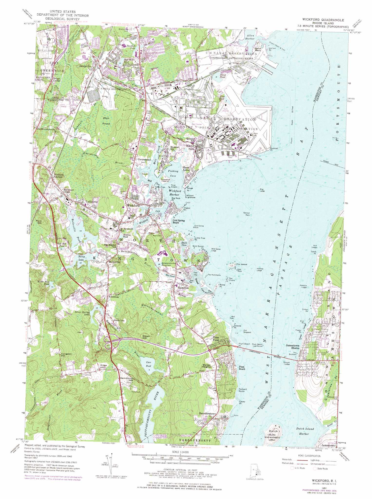
Wickford Topo Map Rhode Island
To zoom in, hover over the map of Wickford
USGS Topo Quad 41071e4 - 1:24,000 scale
| Topo Map Name: | Wickford |
| USGS Topo Quad ID: | 41071e4 |
| Print Size: | ca. 21 1/4" wide x 27" high |
| Southeast Coordinates: | 41.5° N latitude / 71.375° W longitude |
| Map Center Coordinates: | 41.5625° N latitude / 71.4375° W longitude |
| U.S. State: | RI |
| Filename: | o41071e4.jpg |
| Download Map JPG Image: | Wickford topo map 1:24,000 scale |
| Map Type: | Topographic |
| Topo Series: | 7.5´ |
| Map Scale: | 1:24,000 |
| Source of Map Images: | United States Geological Survey (USGS) |
| Alternate Map Versions: |
Wickford RI 1942, updated 1957 Download PDF Buy paper map Wickford RI 1957, updated 1959 Download PDF Buy paper map Wickford RI 1957, updated 1968 Download PDF Buy paper map Wickford RI 1957, updated 1972 Download PDF Buy paper map Wickford RI 1957, updated 1976 Download PDF Buy paper map Wickford RI 1995, updated 1999 Download PDF Buy paper map Wickford RI 2012 Download PDF Buy paper map Wickford RI 2015 Download PDF Buy paper map |
1:24,000 Topo Quads surrounding Wickford
Clayville |
North Scituate |
East Providence |
||
Coventry Center |
Crompton |
East Greenwich |
Bristol |
|
Hope Valley |
Slocum |
Wickford |
Prudence Island |
|
Carolina |
Kingston |
Narragansett Pier |
Newport |
|
Quonochontaug |
> Back to 41071e1 at 1:100,000 scale
> Back to 41070a1 at 1:250,000 scale
> Back to U.S. Topo Maps home
Wickford topo map: Gazetteer
Wickford: Airports
North Kingstown Emergency Operations Pad elevation 15m 49′Quonset Point State Airport elevation 6m 19′
Quonset State Airport elevation 7m 22′
Quonset State Ang Helipad elevation 11m 36′
Wickford: Areas
Devils Foot elevation 31m 101′Wickford: Bars
Slocum Ledge elevation 1m 3′Wickford: Bays
Academy Cove elevation 2m 6′Allen Harbor elevation 1m 3′
Bissel Cove elevation 1m 3′
Fishing Cove elevation 1m 3′
Mill Cove elevation 1m 3′
Wickford Cove elevation 2m 6′
Wickford Harbor elevation 1m 3′
Wickford: Beaches
North Kingstown Beach elevation 9m 29′North Kingstown Town Beach elevation 1m 3′
Plum Beach elevation 31m 101′
Plum Point Beach elevation 1m 3′
Sunset Beach elevation 7m 22′
Wickford: Benches
America Ledge elevation 1m 3′Brig Ledge elevation 1m 3′
Great Ledge elevation 1m 3′
Halfway Ledge elevation 1m 3′
Hull Ledge elevation 1m 3′
Wild Goose Ledge elevation 1m 3′
Wickford: Bridges
Jamestown Bridge elevation 1m 3′Wickford: Capes
Big Rock Point elevation 1m 3′Calf Neck elevation 10m 32′
Casey Point elevation 4m 13′
Cedar Tree Point elevation 6m 19′
Clarks Point elevation 12m 39′
Greene Point elevation 1m 3′
Little Tree Point elevation 1m 3′
Lone Tree Point elevation 2m 6′
Long Point elevation 4m 13′
Plum Beach Point elevation 1m 3′
Point Wharf elevation 8m 26′
Poplar Point elevation 1m 3′
Quonset Point elevation 1m 3′
Rome Point elevation 4m 13′
Sand Point elevation 2m 6′
Sauga Point elevation 1m 3′
Slocum Point (historical) elevation 9m 29′
Spink Neck elevation 7m 22′
Wild Goose Point elevation 4m 13′
Wickford: Channels
The Narrows elevation 1m 3′West Passage elevation 1m 3′
Wickford: Crossings
Interchange 6 elevation 29m 95′Wickford: Dams
Bellville Pond Dam elevation 15m 49′Carr Pond Dam elevation 8m 26′
Potowomut Pond Dam elevation 14m 45′
Silver Spring Lake Dam elevation 12m 39′
Wertz and Viall Pond Dam elevation 10m 32′
Wickford: Islands
Conanicut Island elevation 51m 167′Cornelius Island elevation 10m 32′
Dutch Island elevation 22m 72′
Fox Island elevation 1m 3′
Rabbit Island elevation 3m 9′
Wickford: Lakes
Annaquatucket Mill Pond elevation 11m 36′Belleville Pond elevation 15m 49′
Davol Pond elevation 5m 16′
Duck Cove elevation 1m 3′
Frys Pond elevation 1m 3′
Jenkins Pond elevation 17m 55′
Kettle Hole Pond elevation 18m 59′
Oak Hill Pond elevation 28m 91′
Sandhill Pond elevation 11m 36′
Saw Mill Pond elevation 12m 39′
Secret Lake elevation 15m 49′
Silver Spring Lake elevation 12m 39′
Wickford: Parks
Cocumscussoc State Park elevation 21m 68′Davis Memorial Wildlife Refuge elevation 21m 68′
Davisville Historic District elevation 24m 78′
Dutch Island Management Area elevation 23m 75′
Feurer Park elevation 33m 108′
Hamilton Mill Village Historic District elevation 15m 49′
Pettaquamscutt Cove National Wildlife Refuge elevation 33m 108′
Richard Smiths Grove elevation 16m 52′
Ryan Park elevation 25m 82′
Saunderstown Historic District elevation 27m 88′
Shady LEa Historic District elevation 17m 55′
Wickford Historic District elevation 8m 26′
Wickford: Pillars
Charles Rock elevation 1m 3′Cold Spring Rock elevation 1m 3′
Dick Rock elevation 1m 3′
Fowler Rock elevation 1m 3′
General Rock elevation 1m 3′
Hannah Robinson Rock elevation 12m 39′
Mill Rock elevation 1m 3′
Old Sergeant elevation 1m 3′
Old Sow Rock elevation 1m 3′
Packard Rocks elevation 13m 42′
Red Rock elevation 1m 3′
Seal Rock elevation 1m 3′
Sinker Rock elevation 1m 3′
The Brothers elevation 1m 3′
The Clump elevation 1m 3′
The Hummocks elevation 1m 3′
Three Sisters elevation 1m 3′
Wickford: Populated Places
Allenton elevation 28m 91′Annaquatucket elevation 17m 55′
Belleville elevation 21m 68′
Cold Spring Beach elevation 1m 3′
Congdon Hill (historical) elevation 59m 193′
Davisville elevation 25m 82′
Hamilton elevation 17m 55′
Jamestown Shores elevation 13m 42′
Kiefer Park elevation 13m 42′
Lafayette elevation 23m 75′
Narragansett Terrace elevation 15m 49′
North Kingstown elevation 25m 82′
Plum Beach elevation 1m 3′
Plum Point elevation 33m 108′
Saunderstown elevation 38m 124′
Shore Acres elevation 11m 36′
Wickford elevation 20m 65′
Wickford Junction elevation 31m 101′
Wickford: Post Offices
North Kingstown Post Office elevation 13m 42′Saunderstown Post Office elevation 39m 127′
Wickford Post Office elevation 20m 65′
Wickford: Reservoirs
Annaquatucket Reservoir elevation 13m 42′Carr Pond elevation 8m 26′
Mill Pond elevation 9m 29′
Potowomut Pond elevation 14m 45′
Rodman Mill Pond elevation 17m 55′
Wertz and Viall Pond elevation 10m 32′
Wickford: Streams
Annaquatucket River elevation 1m 3′Cocumcussoc Brook elevation 5m 16′
Eldridge Creek (historical) elevation 11m 36′
Great Creek elevation 1m 3′
Hall Creek elevation 13m 42′
Halls Creek elevation 10m 32′
Jamestown Brook elevation 2m 6′
Mattatuxet River elevation 9m 29′
Mill Creek elevation 1m 3′
Pine River elevation 9m 29′
Sandhill Brook elevation 25m 82′
Scrabbletown Brook elevation 23m 75′
Shewatuck Brook (historical) elevation 5m 16′
Viall Creek (historical) elevation 1m 3′
Wannuchecomecut Brook elevation 1m 3′
Wickford: Summits
Barber Heights elevation 68m 223′Briggs Corner elevation 23m 75′
Cocumcussoc elevation 18m 59′
Congdon Hill elevation 75m 246′
Hammond Hill elevation 73m 239′
Hornbeam Chapel elevation 29m 95′
Pork Hill elevation 46m 150′
Ridge Hill elevation 44m 144′
Shady Lea elevation 15m 49′
Stook Hill elevation 40m 131′
Wickford: Swamps
Allens Pond Marshes elevation 52m 170′Black Swamp elevation 27m 88′
Wickford: Woods
Lincoln Woods elevation 1m 3′Wickford digital topo map on disk
Buy this Wickford topo map showing relief, roads, GPS coordinates and other geographical features, as a high-resolution digital map file on DVD:
Maine, New Hampshire, Rhode Island & Eastern Massachusetts
Buy digital topo maps: Maine, New Hampshire, Rhode Island & Eastern Massachusetts