Bristol Topo Map Rhode Island
To zoom in, hover over the map of Bristol
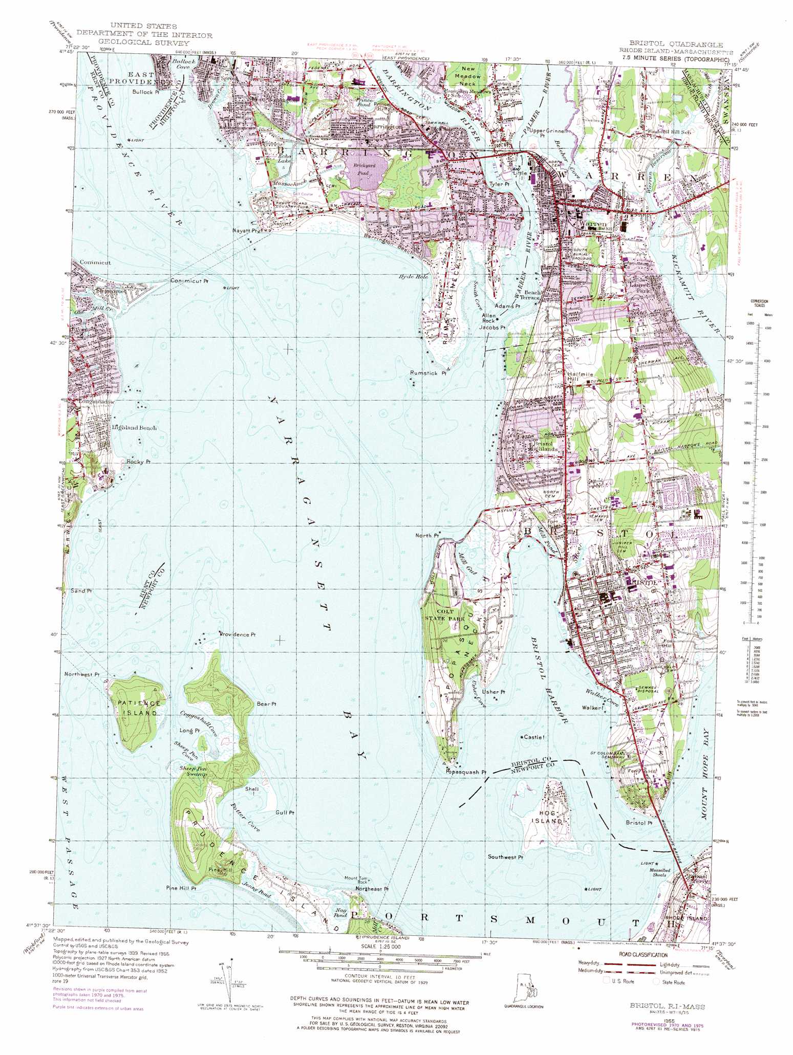
USGS Topo Quad 41071f3 - 1:24,000 scale
| Topo Map Name: | Bristol |
| USGS Topo Quad ID: | 41071f3 |
| Print Size: | ca. 21 1/4" wide x 27" high |
| Southeast Coordinates: | 41.625° N latitude / 71.25° W longitude |
| Map Center Coordinates: | 41.6875° N latitude / 71.3125° W longitude |
| U.S. States: | RI, MA |
| Filename: | o41071f3.jpg |
| Download Map JPG Image: | Bristol topo map 1:24,000 scale |
| Map Type: | Topographic |
| Topo Series: | 7.5´ |
| Map Scale: | 1:24,000 |
| Source of Map Images: | United States Geological Survey (USGS) |
| Alternate Map Versions: |
Bristol RI 1955, updated 1955 Download PDF Buy paper map Bristol RI 1955, updated 1966 Download PDF Buy paper map Bristol RI 1955, updated 1973 Download PDF Buy paper map Bristol RI 1955, updated 1976 Download PDF Buy paper map Bristol RI 1955, updated 1983 Download PDF Buy paper map Bristol RI 1955, updated 1983 Download PDF Buy paper map Bristol RI 2012 Download PDF Buy paper map Bristol RI 2015 Download PDF Buy paper map |
1:24,000 Topo Quads surrounding Bristol
Georgiaville |
Attleboro |
Taunton |
||
North Scituate |
East Providence |
Assonet |
||
Crompton |
East Greenwich |
Bristol |
Fall River East |
|
Slocum |
Wickford |
Prudence Island |
Westport |
|
Kingston |
Narragansett Pier |
Newport |
Sakonnet Point |
> Back to 41071e1 at 1:100,000 scale
> Back to 41070a1 at 1:250,000 scale
> Back to U.S. Topo Maps home
Bristol topo map: Gazetteer
Bristol: Airports
Boystown Fly-in-Ranch elevation 1m 3′Bristol: Bars
Barren Ledge elevation 1m 3′Fork Rocks elevation 1m 3′
Johnson Ledge elevation 1m 3′
Middle Ground elevation 1m 3′
Musselbed Shoals elevation 1m 3′
Ohio Ledge elevation 1m 3′
Pine Hill ledge elevation 1m 3′
Rumstick Ledge elevation 1m 3′
Rumstick Shoal elevation 1m 3′
The Brothers elevation 1m 3′
Upper Middle Ground elevation 1m 3′
Bristol: Bays
Belcher Cove elevation 2m 6′Bristol Harbor elevation 1m 3′
Coggeshall Cove elevation 1m 3′
Deep Hole elevation 1m 3′
Drown Cove elevation 1m 3′
Hyde Hole elevation 1m 3′
Potter Cove elevation 1m 3′
Sheep Pen Cove elevation 1m 3′
Smith Cove elevation 1m 3′
Usher Cove elevation 1m 3′
Walker Cove elevation 1m 3′
Bristol: Beaches
Barrington Beach elevation 2m 6′Bristol Town Beach elevation 1m 3′
Longmeadow Beach elevation 1m 3′
Rocky Point Beach elevation 2m 6′
Warren Town Beach elevation 4m 13′
Bristol: Benches
Allen Ledge elevation 1m 3′Pine Hill Ledge elevation 1m 3′
Bristol: Bridges
Barrington Bridge elevation 2m 6′Mount Hope Bridge elevation 1m 3′
Warren Bridge elevation 4m 13′
Bristol: Capes
Adams Point elevation 6m 19′Allen Neck elevation 4m 13′
Bear Point elevation 9m 29′
Bristol Neck elevation 17m 55′
Bristol Point elevation 10m 32′
Bullock Point elevation 3m 9′
Conimicut Point elevation 1m 3′
Gull Point elevation 3m 9′
Jacobs Point elevation 1m 3′
Long Point elevation 3m 9′
Martin Point elevation 5m 16′
Nayatt Point elevation 2m 6′
North Point elevation 11m 36′
Northeast Point elevation 3m 9′
Northwest Point elevation 5m 16′
Phebes Neck elevation 11m 36′
Pine Hill Point elevation 13m 42′
Popasquash Neck elevation 12m 39′
Popasquash Point elevation 3m 9′
Providence Point elevation 10m 32′
Rocky Point elevation 1m 3′
Rumstick Neck elevation 8m 26′
Rumstick Point elevation 3m 9′
Sand Point elevation 2m 6′
Southwest Point elevation 1m 3′
Tyler Point elevation 2m 6′
Upper Grinnell Point elevation 2m 6′
Usher Point elevation 4m 13′
Bristol: Channels
Bullock Point Reach elevation 1m 3′Conimicut Point Reach elevation 1m 3′
Entrance Channel elevation 1m 3′
Rumstick Neck Reach elevation 1m 3′
Bristol: Cliffs
Ferry Cliff elevation 23m 75′Tree Point Rocks elevation 1m 3′
Usher Rocks elevation 1m 3′
Bristol: Dams
Warren Reservoir Lower Dam elevation 2m 6′Warren Reservoir Upper Dam elevation 3m 9′
Bristol: Guts
Mill Gut elevation 2m 6′Bristol: Islands
Castle Island elevation 1m 3′Hog Island elevation 10m 32′
Little Island elevation 1m 3′
Patience Island elevation 16m 52′
Pomham Rocks Island elevation 1m 3′
Shell Island elevation 1m 3′
Walker Island elevation 1m 3′
Bristol: Lakes
Jenny Pond elevation 10m 32′Mill Pond elevation 11m 36′
Nag Pond elevation 9m 29′
Prince Pond elevation 2m 6′
Bristol: Parks
Barrington Civic Center Historic District elevation 10m 32′Bay Island Park elevation 18m 59′
Blithewold Mansion and Gardens elevation 25m 82′
Bristol Playground elevation 17m 55′
Bristol Town Common elevation 17m 55′
Colt State Park elevation 21m 68′
Conimicut Point Park elevation 0m 0′
Crescent Park elevation 1m 3′
Peck Center Playground elevation 7m 22′
Rock Point Amusement Park elevation 6m 19′
Rockwell Park elevation 3m 9′
Veterans Memorial Park elevation 15m 49′
Veterans Park elevation 4m 13′
Walley Park elevation 1m 3′
Warren Common elevation 11m 36′
Warrens Waterfront Historic District elevation 1m 3′
Bristol: Pillars
Allen Rock elevation 1m 3′Barden Rock elevation 1m 3′
Blackstone Rock elevation 1m 3′
Deyer Rock elevation 1m 3′
Longmeadow Rock elevation 1m 3′
Mount Tom Rock elevation 1m 3′
Penivs Rock elevation 1m 3′
Rumstick Rock elevation 1m 3′
The Brothers elevation 1m 3′
Bristol: Populated Places
Annawomscutt elevation 5m 16′Barrington elevation 7m 22′
Bay Spring elevation 6m 19′
Beach Terrace elevation 6m 19′
Bristol elevation 35m 114′
Bristol Ferry elevation 23m 75′
Bristol Highlands elevation 35m 114′
Bristol Township elevation 38m 124′
East Warren elevation 13m 42′
Highland Beach elevation 7m 22′
Laurel Park elevation 13m 42′
Longmeadow elevation 23m 75′
Maxfields Corner elevation 7m 22′
Nag Creek elevation 1m 3′
Nayatt elevation 20m 65′
Pocasset Heights elevation 25m 82′
River View elevation 6m 19′
Rocky Point elevation 21m 68′
Sowams (historical) elevation 3m 9′
Warren elevation 15m 49′
West Barrington elevation 9m 29′
Bristol: Post Offices
Barrington Post Office elevation 2m 6′Bristol Post Office elevation 13m 42′
Warren Post Office elevation 8m 26′
Bristol: Reservoirs
Brickyard Pond elevation 0m 0′Echo Lake elevation 2m 6′
Volpes Pond elevation 7m 22′
Warren Reservoir elevation 2m 6′
Warren Reservoir Upper elevation 3m 9′
Bristol: Springs
Massasoit Spring elevation 3m 9′Bristol: Streams
Annawomscutt Brook elevation 4m 13′Barrington River elevation 1m 3′
Heath Brook elevation 11m 36′
Heath Brook elevation 5m 16′
Mussachuck Creek elevation 1m 3′
Old Mill Creek elevation 1m 3′
Palmer River elevation 1m 3′
Silver Creek elevation 1m 3′
Walker Creek elevation 1m 3′
Warren River elevation 1m 3′
Bristol: Summits
Burr Hill elevation 8m 26′Ferry Hill elevation 43m 141′
Fort Hill elevation 19m 62′
Fox Hill elevation 27m 88′
Halfmile Hill elevation 48m 157′
Juniper Hill elevation 54m 177′
Pine Hill elevation 13m 42′
Prince Hill elevation 14m 45′
Windmill Hill elevation 20m 65′
Bristol: Swamps
Sheep Pen Swamp elevation 3m 9′Bristol digital topo map on disk
Buy this Bristol topo map showing relief, roads, GPS coordinates and other geographical features, as a high-resolution digital map file on DVD:
Maine, New Hampshire, Rhode Island & Eastern Massachusetts
Buy digital topo maps: Maine, New Hampshire, Rhode Island & Eastern Massachusetts