East Greenwich Topo Map Rhode Island
To zoom in, hover over the map of East Greenwich
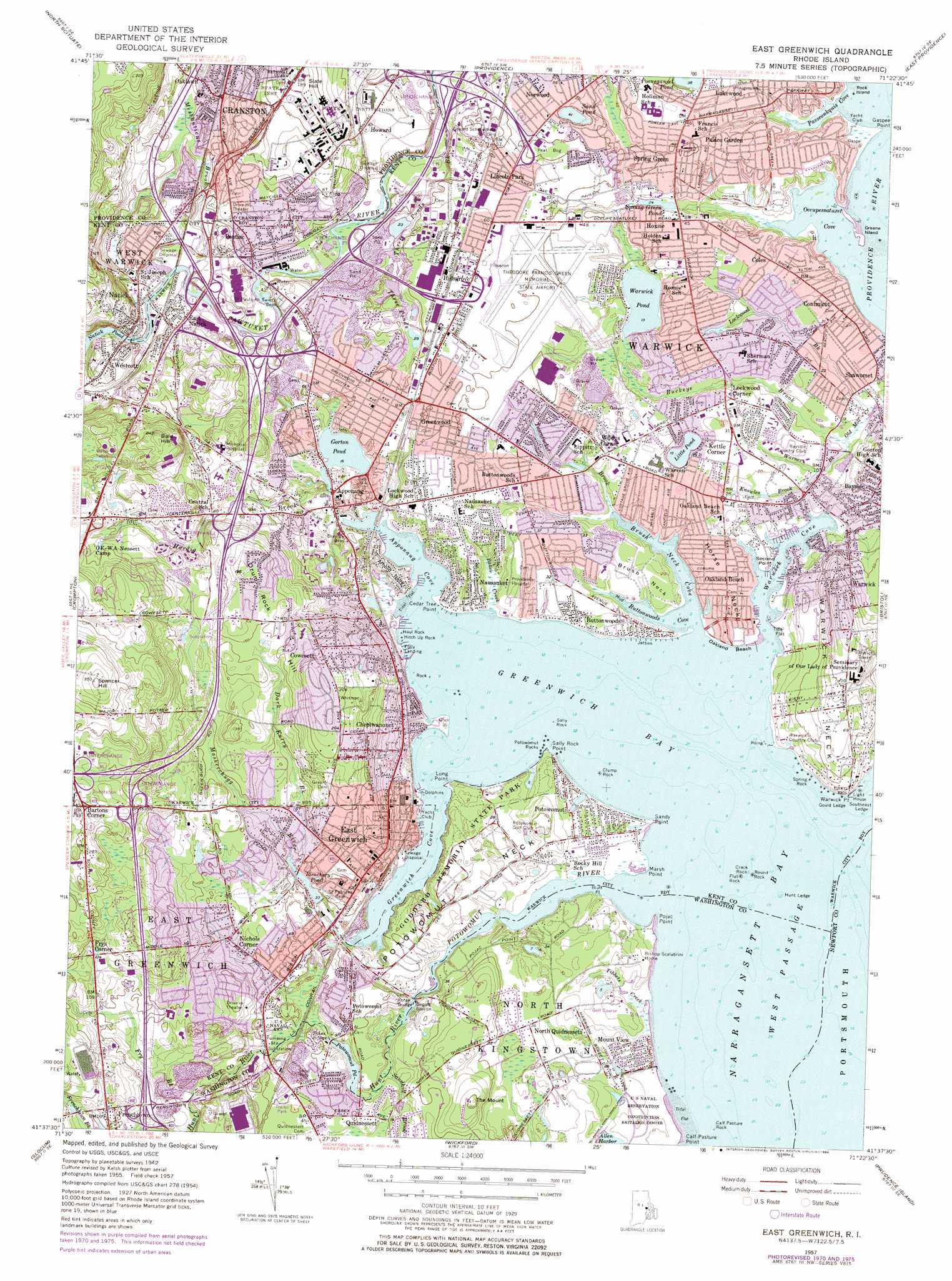
USGS Topo Quad 41071f4 - 1:24,000 scale
| Topo Map Name: | East Greenwich |
| USGS Topo Quad ID: | 41071f4 |
| Print Size: | ca. 21 1/4" wide x 27" high |
| Southeast Coordinates: | 41.625° N latitude / 71.375° W longitude |
| Map Center Coordinates: | 41.6875° N latitude / 71.4375° W longitude |
| U.S. State: | RI |
| Filename: | o41071f4.jpg |
| Download Map JPG Image: | East Greenwich topo map 1:24,000 scale |
| Map Type: | Topographic |
| Topo Series: | 7.5´ |
| Map Scale: | 1:24,000 |
| Source of Map Images: | United States Geological Survey (USGS) |
| Alternate Map Versions: |
East Greenwich RI 1942, updated 1958 Download PDF Buy paper map East Greenwich RI 1957, updated 1959 Download PDF Buy paper map East Greenwich RI 1957, updated 1973 Download PDF Buy paper map East Greenwich RI 1957, updated 1977 Download PDF Buy paper map East Greenwich RI 1957, updated 1984 Download PDF Buy paper map East Greenwich RI 1996, updated 2000 Download PDF Buy paper map East Greenwich RI 2012 Download PDF Buy paper map East Greenwich RI 2015 Download PDF Buy paper map |
1:24,000 Topo Quads surrounding East Greenwich
Chepachet |
Georgiaville |
Attleboro |
||
Clayville |
North Scituate |
East Providence |
||
Coventry Center |
Crompton |
East Greenwich |
Bristol |
|
Hope Valley |
Slocum |
Wickford |
Prudence Island |
|
Carolina |
Kingston |
Narragansett Pier |
Newport |
> Back to 41071e1 at 1:100,000 scale
> Back to 41070a1 at 1:250,000 scale
> Back to U.S. Topo Maps home
East Greenwich topo map: Gazetteer
East Greenwich: Airports
Theodore Francis Green Memorial State Airport elevation 18m 59′East Greenwich: Bars
Gould Ledge elevation 1m 3′Hunt Ledge elevation 1m 3′
Round Rock elevation 1m 3′
Southeast Ledge elevation 1m 3′
East Greenwich: Bays
Apponaug Cove elevation 1m 3′Brush Neck Cove elevation 1m 3′
Buttonwoods Cove elevation 1m 3′
Flat Cove elevation 1m 3′
Flat Cove (historical) elevation 8m 26′
Gates Cove elevation 1m 3′
Greenwich Bay elevation 1m 3′
Greenwich Cove elevation 1m 3′
Occupessatuxet Cove elevation 1m 3′
Passeonkquis Cove elevation 3m 9′
Warwick Cove elevation 1m 3′
East Greenwich: Beaches
Buttonwoods Beach elevation 5m 16′Calf Pasture Point Beach elevation 1m 3′
Goddard Memorial State Park Beach elevation 3m 9′
Sandy Beach elevation 5m 16′
Sandy Point Beach elevation 5m 16′
East Greenwich: Bridges
Forge Bridge elevation 6m 19′Hunts River Bridge elevation 16m 52′
East Greenwich: Capes
Arnold Neck elevation 9m 29′Bluff Point elevation 6m 19′
Brush Neck elevation 9m 29′
Calf Pasture Point elevation 1m 3′
Cedar Tree Point elevation 1m 3′
Chepiwanoxet Point elevation 2m 6′
Gaspee Point elevation 1m 3′
Horse Neck elevation 7m 22′
Long Point elevation 3m 9′
Marsh Point elevation 3m 9′
Pojac Point elevation 1m 3′
Potowomut Neck elevation 21m 68′
Sally Rock Point elevation 4m 13′
Sandy Point elevation 3m 9′
Second Point elevation 3m 9′
Warwick Neck elevation 30m 98′
Warwick Point elevation 7m 22′
East Greenwich: Crossings
Interchange 1 elevation 22m 72′Interchange 1 elevation 30m 98′
Interchange 10 elevation 31m 101′
Interchange 10A elevation 36m 118′
Interchange 10B elevation 32m 104′
Interchange 11 elevation 33m 108′
Interchange 12 elevation 26m 85′
Interchange 12 elevation 31m 101′
Interchange 12A elevation 21m 68′
Interchange 12B elevation 13m 42′
Interchange 13 elevation 16m 52′
Interchange 14 elevation 18m 59′
Interchange 14A elevation 17m 55′
Interchange 14B elevation 9m 29′
Interchange 2 elevation 8m 26′
Interchange 4A elevation 14m 45′
Interchange 4B elevation 15m 49′
Interchange 5A elevation 25m 82′
Interchange 5B elevation 28m 91′
Interchange 7 elevation 31m 101′
Interchange 8A elevation 61m 200′
Interchange 8B elevation 66m 216′
Interchange 8B elevation 74m 242′
Interchange 9 elevation 68m 223′
East Greenwich: Dams
Fruit of the Loom Dam elevation 13m 42′Gorton Pond Dam elevation 5m 16′
Natick Pond Dam elevation 27m 88′
East Greenwich: Islands
Greene Island elevation 1m 3′Old Pier Rock elevation 1m 3′
Rock Island elevation 0m 0′
East Greenwich: Lakes
Crescent Lake elevation 3m 9′Duck Pond (historical) elevation 23m 75′
Gorton Pond elevation 5m 16′
Little Pond elevation 5m 16′
Posneganset Pond elevation 11m 36′
Potowomut Pond elevation 5m 16′
Sand Pond elevation 16m 52′
Three Ponds elevation 9m 29′
Warwick Pond elevation 4m 13′
East Greenwich: Parks
Apponaug Historic District elevation 8m 26′Buttonwoods Beach Historic District elevation 5m 16′
East Greenwich Historic District elevation 41m 134′
Forge Road Historic District elevation 6m 19′
Goddard Memorial State Park elevation 19m 62′
John D Memorial Park elevation 28m 91′
Oak Lawn Village Historic District elevation 27m 88′
East Greenwich: Pillars
Calf Pasture Rock elevation 1m 3′Clump Rock elevation 1m 3′
Crack Rock elevation 1m 3′
Drum Rock elevation 23m 75′
Flat Rock elevation 1m 3′
Haul Rock elevation 1m 3′
Hitch Up Rock elevation 1m 3′
Potowomut Rocks elevation 1m 3′
Round Rock elevation 1m 3′
Sally Rock elevation 1m 3′
Spring Rock elevation 1m 3′
East Greenwich: Populated Places
Apponaug elevation 11m 36′Bartons Corner elevation 80m 262′
Bayside elevation 18m 59′
Buttonwoods elevation 8m 26′
Chepiwanoxet elevation 15m 49′
Coles elevation 17m 55′
Conimicut elevation 14m 45′
Cowesett elevation 67m 219′
Crossways (historical) elevation 19m 62′
East Greenwich elevation 48m 157′
East Natick elevation 32m 104′
Folly Landing elevation 8m 26′
Frenchtown elevation 39m 127′
Frys Corner elevation 52m 170′
Greenwood elevation 25m 82′
Hillsgrove elevation 24m 78′
Hoxsie elevation 18m 59′
Kettle Corner elevation 13m 42′
Lincoln Park elevation 25m 82′
Lockwood Corner elevation 13m 42′
Meadow View elevation 5m 16′
Mount View elevation 12m 39′
Natick elevation 29m 95′
Nausauket elevation 16m 52′
Nichols Corner elevation 28m 91′
North Quidnessett elevation 14m 45′
Oakland Beach elevation 9m 29′
Old Warwick elevation 9m 29′
Palace Garden elevation 18m 59′
Pontiac elevation 23m 75′
Potowomut elevation 16m 52′
Quidnessett elevation 17m 55′
Shawomet elevation 7m 22′
Spring Green elevation 21m 68′
Thatch Cove (historical) elevation 10m 32′
Warwick elevation 11m 36′
Westcott elevation 31m 101′
Wildes Corner elevation 17m 55′
East Greenwich: Post Offices
Apponaug Station Post Office elevation 17m 55′East Greenwich Post Office elevation 22m 72′
Richard L Cevoli Post Office elevation 21m 68′
Warwick Post Office elevation 18m 59′
East Greenwich: Reservoirs
Bleachery Pond elevation 10m 32′Ishmael Lake elevation 9m 29′
Natick Pond elevation 27m 88′
Pawtuxet River elevation 13m 42′
Spring Green Pond elevation 10m 32′
East Greenwich: Streams
Baker Creek elevation 2m 6′Buckeye Brook elevation 7m 22′
Carder Creek elevation 2m 6′
Dark Entry Brook elevation 20m 65′
Frenchtown Brook elevation 22m 72′
Fry Brook elevation 19m 62′
Hardig Brook elevation 1m 3′
Hunt River elevation 4m 13′
Knowles Brook elevation 10m 32′
Lockwood Brook elevation 4m 13′
Marys Creek elevation 1m 3′
Maskerchugg River elevation 9m 29′
Meshanticut Brook elevation 5m 16′
Potowomut River elevation 1m 3′
Three Ponds Brook elevation 12m 39′
Tibbets Creek elevation 2m 6′
Tuscatucket Brook elevation 7m 22′
Warner Brook elevation 5m 16′
East Greenwich: Summits
Bald Hill elevation 70m 229′Drum Rock Hill elevation 82m 269′
Slate Hill elevation 56m 183′
Spencer Hill elevation 113m 370′
The Mount elevation 34m 111′
East Greenwich: Valleys
Pawtuxet Valley elevation 12m 39′East Greenwich digital topo map on disk
Buy this East Greenwich topo map showing relief, roads, GPS coordinates and other geographical features, as a high-resolution digital map file on DVD:
Maine, New Hampshire, Rhode Island & Eastern Massachusetts
Buy digital topo maps: Maine, New Hampshire, Rhode Island & Eastern Massachusetts