Assonet Topo Map Massachusetts
To zoom in, hover over the map of Assonet
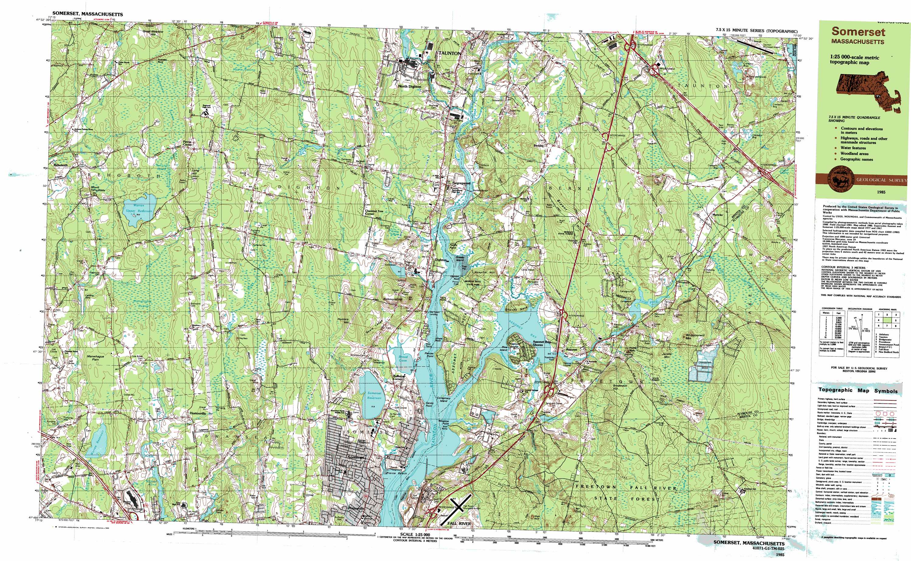
USGS Topo Quad 41071g1 - 1:25,000 scale
| Topo Map Name: | Assonet |
| USGS Topo Quad ID: | 41071g1 |
| Print Size: | ca. 39" wide x 24" high |
| Southeast Coordinates: | 41.75° N latitude / 71° W longitude |
| Map Center Coordinates: | 41.8125° N latitude / 71.125° W longitude |
| U.S. State: | MA |
| Filename: | k41071g1.jpg |
| Download Map JPG Image: | Assonet topo map 1:25,000 scale |
| Map Type: | Topographic |
| Topo Series: | 7.5´x15´ |
| Map Scale: | 1:25,000 |
| Source of Map Images: | United States Geological Survey (USGS) |
| Alternate Map Versions: |
Somerset MA 1985, updated 1985 Download PDF Buy paper map Somerset MA 1985, updated 1985 Download PDF Buy paper map |
1:24,000 Topo Quads surrounding Assonet
Wrentham |
Brockton |
Whitman |
Hanover |
|
Attleboro |
Taunton |
Bridgewater |
Plympton |
|
East Providence |
Assonet |
Assawompset Pond |
Snipatuit Pond |
|
Bristol |
Fall River East |
New Bedford North |
Marion |
|
Prudence Island |
Westport |
New Bedford South |
Sconticut Neck |
> Back to 41071e1 at 1:100,000 scale
> Back to 41070a1 at 1:250,000 scale
> Back to U.S. Topo Maps home
Assonet topo map: Gazetteer
Assonet: Airports
Fall River Municipal Airport elevation 57m 187′Myricks Airport elevation 21m 68′
Princess House Heliport elevation 4m 13′
Taunton Municipal Airport elevation 9m 29′
Assonet: Basins
Assonet Bay elevation 4m 13′Assonet: Bays
Broad Cove elevation 1m 3′Shepherds Cove elevation 1m 3′
Assonet: Beaches
Pierce Beach elevation 4m 13′Assonet: Bridges
Berkley Bridge elevation 1m 3′Assonet: Capes
Assonet Neck elevation 13m 42′Bryants Neck elevation 2m 6′
Ferry Point elevation 1m 3′
Peters Point elevation 2m 6′
Pierces Point elevation 5m 16′
Sandy Point elevation 2m 6′
Shoves Neck elevation 12m 39′
Winslow Point elevation 2m 6′
Assonet: Crossings
Interchange Eleven elevation 18m 59′Interchange Ten elevation 28m 91′
Interchange Thirty-five elevation 14m 45′
Interchange Thirty-four elevation 35m 114′
Interchange Thirty-seven elevation 52m 170′
Interchange Thirty-six elevation 10m 32′
Interchange Thirty-three elevation 14m 45′
Assonet: Dams
Boynton Dam elevation 13m 42′Cole River Pond Dam elevation 9m 29′
Forge Pond Dam elevation 17m 55′
Milford Pond Dam elevation 8m 26′
Muddy Cove Pond Dam elevation 9m 29′
Somerset Reservoir Dam elevation 11m 36′
Terry Brook Pond Dam elevation 16m 52′
Three Mile River Dam elevation 6m 19′
Warren Reservoir Dam elevation 21m 68′
Warren Upper Reservoir Dam elevation 28m 91′
Assonet: Forests
Emma N F Hutt Forest elevation 29m 95′Freetown Fall River State Forest elevation 61m 200′
Assonet: Islands
Conspiracy Island elevation 1m 3′Dighton Rock elevation 1m 3′
Grassy Island elevation 1m 3′
Pine Island elevation 1m 3′
Wescott Island elevation 2m 6′
Whale Rock elevation 1m 3′
Assonet: Parks
Buffington Park elevation 28m 91′Dighton Rock State Park elevation 20m 65′
Assonet: Plains
Manwhague Plain elevation 25m 82′Assonet: Populated Places
Assonet elevation 7m 22′Assonet Bay Shores elevation 2m 6′
Berkley elevation 23m 75′
Berkley Bridge elevation 1m 3′
Buffington Corner elevation 33m 108′
Camp Merriwood elevation 7m 22′
Camp Welch elevation 9m 29′
Chestnut Tree Corner elevation 21m 68′
Dighton elevation 4m 13′
Hortonville elevation 20m 65′
Myricks elevation 19m 62′
North Dighton elevation 10m 32′
Old Town Landing elevation 1m 3′
Perrys Corner elevation 52m 170′
Pottersville elevation 17m 55′
Rehoboth elevation 13m 42′
Segreganset elevation 10m 32′
Somerset elevation 13m 42′
West Dighton elevation 56m 183′
Assonet: Post Offices
Assonet Post Office elevation 11m 36′North Dighton Post Office elevation 19m 62′
Rehoboth Post Office elevation 19m 62′
Swansea Post Office elevation 18m 59′
Assonet: Reservoirs
Assonet River Reservoir elevation 13m 42′Cole River Pond elevation 9m 29′
Forge Pond elevation 17m 55′
Milford Pond elevation 6m 19′
Muddy Cove Pond elevation 9m 29′
Somerset Reservoir elevation 11m 36′
Terry Brook Pond elevation 16m 52′
Three Mile River elevation 6m 19′
Warren Reservoir elevation 21m 68′
Warren Upper Reservoir elevation 26m 85′
Assonet: Ridges
Beals Ledge elevation 29m 95′Assonet: Streams
Assonet River elevation 1m 3′Bad Luck Brook elevation 15m 49′
Cedar Swamp River elevation 14m 45′
Holloway Brook elevation 14m 45′
Labor in Vain Creek elevation 2m 6′
Mother Brook elevation 2m 6′
Muddy Cove Brook elevation 1m 3′
Peirce Brook elevation 14m 45′
Quaker Brook elevation 13m 42′
Rattlesnake Brook elevation 1m 3′
Segreganset River elevation 1m 3′
Sunken Brook elevation 4m 13′
The Creek elevation 2m 6′
Threemile River elevation 1m 3′
Assonet: Summits
Annawan Rock elevation 33m 108′Breakneck Hill elevation 64m 209′
Bryant Hill elevation 46m 150′
Hospital Hill elevation 24m 78′
Hunters Hill elevation 57m 187′
Jacobs Mountain elevation 47m 154′
Long Hill elevation 61m 200′
Mount Terrydiddle elevation 31m 101′
Profile Rock elevation 24m 78′
Richmond Hill elevation 56m 183′
Whippoorwill Mountain elevation 41m 134′
Assonet: Swamps
Bad Luck Swamp elevation 31m 101′Cedar Swamp elevation 52m 170′
Cedar Swamp elevation 5m 16′
Manwhague Swamp elevation 22m 72′
Maple Swamp elevation 35m 114′
Poppasguash Swamp elevation 32m 104′
Squannakonk Swamp elevation 31m 101′
The Marsh elevation 3m 9′
Assonet digital topo map on disk
Buy this Assonet topo map showing relief, roads, GPS coordinates and other geographical features, as a high-resolution digital map file on DVD:
Maine, New Hampshire, Rhode Island & Eastern Massachusetts
Buy digital topo maps: Maine, New Hampshire, Rhode Island & Eastern Massachusetts