East Providence Topo Map Massachusetts
To zoom in, hover over the map of East Providence
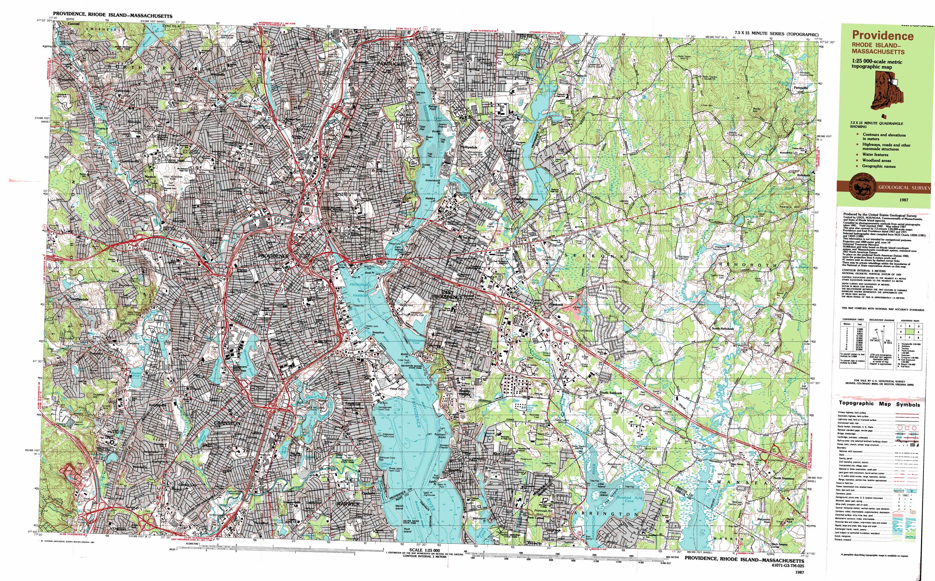
USGS Topo Quad 41071g3 - 1:25,000 scale
| Topo Map Name: | East Providence |
| USGS Topo Quad ID: | 41071g3 |
| Print Size: | ca. 39" wide x 24" high |
| Southeast Coordinates: | 41.75° N latitude / 71.25° W longitude |
| Map Center Coordinates: | 41.8125° N latitude / 71.375° W longitude |
| U.S. States: | MA, RI |
| Filename: | k41071g3.jpg |
| Download Map JPG Image: | East Providence topo map 1:25,000 scale |
| Map Type: | Topographic |
| Topo Series: | 7.5´x15´ |
| Map Scale: | 1:25,000 |
| Source of Map Images: | United States Geological Survey (USGS) |
| Alternate Map Versions: |
Providence RI 1987, updated 1987 Download PDF Buy paper map Providence RI 1987, updated 1987 Download PDF Buy paper map |
1:24,000 Topo Quads surrounding East Providence
Blackstone |
Wrentham |
Brockton |
||
Georgiaville |
Attleboro |
Taunton |
||
North Scituate |
East Providence |
Assonet |
||
Crompton |
East Greenwich |
Bristol |
Fall River East |
|
Slocum |
Wickford |
Prudence Island |
Westport |
> Back to 41071e1 at 1:100,000 scale
> Back to 41070a1 at 1:250,000 scale
> Back to U.S. Topo Maps home
East Providence topo map: Gazetteer
East Providence: Airports
Downtown Providence Helistop elevation 2m 6′One Hospital Trust Airport elevation 2m 6′
Promet Airport elevation 2m 6′
East Providence: Areas
Blackstone Park elevation 19m 62′Cranston Print Works elevation 23m 75′
Eden Park elevation 18m 59′
East Providence: Bars
Green Jacket Shoal elevation 0m 0′East Providence: Bays
Baileys Lower Cove elevation 0m 0′Baileys Upper Cove elevation 0m 0′
Bishop Cove elevation 0m 0′
Bullock Cove elevation 1m 3′
Burges Cove elevation 0m 0′
Copps Cave elevation 9m 29′
Copps Cove elevation 0m 0′
Corliss Cove elevation 2m 6′
Hundred Acre Cove elevation 0m 0′
Mile End Cove elevation 0m 0′
Pawtuxet Cove elevation 0m 0′
Providence Harbor elevation 0m 0′
Round Cove elevation 3m 9′
Sassafras Cove elevation 0m 0′
Stillhouse Cove elevation 0m 0′
Watchemoket Cove elevation 1m 3′
East Providence: Beaches
Edgewood Beach elevation 0m 0′Twin Rivers Beach elevation 68m 223′
Twin Rivers Beach East elevation 62m 203′
East Providence: Bends
Silver Hook elevation 3m 9′East Providence: Bridges
Boston and Providence Railroad Bridge elevation 7m 22′Crawford Street Bridge elevation 2m 6′
Division Street Bridge elevation 3m 9′
India Bridge (historical) elevation 2m 6′
Pawtuxet Bridge elevation 2m 6′
Point Street Bridge elevation 0m 0′
Red Bridge elevation 0m 0′
Washington Bridge elevation 0m 0′
Weybosset Bridge (historical) elevation 0m 0′
East Providence: Capes
Antushantuck Neck elevation 27m 88′Bass Rock elevation 5m 16′
Bensley Point elevation 0m 0′
Bishop Point elevation 3m 9′
Bold Point elevation 2m 6′
Bucklin Point elevation 6m 19′
Bullock Neck elevation 12m 39′
Cold Spring Point elevation 2m 6′
Cowpen Point elevation 0m 0′
Crook Point elevation 1m 3′
Fields Point elevation 2m 6′
Fox Point elevation 0m 0′
Goose Point elevation 1m 3′
Greenwood Point elevation 5m 16′
India Point elevation 2m 6′
Kettle Point elevation 0m 0′
Moshassuck elevation 50m 164′
New Meadow Neck elevation 3m 9′
Pawtuxet Neck elevation 0m 0′
Pleasure Lake elevation 9m 29′
Richmond Point elevation 1m 3′
Sabin Point elevation 2m 6′
Sassafras Point elevation 3m 9′
Squantum Point elevation 7m 22′
Stony Point elevation 0m 0′
Swan Point elevation 1m 3′
The Tongue elevation 2m 6′
Walker Point elevation 7m 22′
Washouset Point elevation 5m 16′
Watchemoket Point elevation 2m 6′
Waybaussett Neck elevation 1m 3′
East Providence: Channels
Fox Point Reach elevation 0m 0′Fuller Rock Reach elevation 0m 0′
Sabin Point Reach elevation 0m 0′
East Providence: Crossings
Interchange 1 elevation 17m 55′Interchange 15 elevation 9m 29′
Interchange 17 elevation 17m 55′
Interchange 17 elevation 12m 39′
Interchange 19 elevation 6m 19′
Interchange 1A elevation 13m 42′
Interchange 1B elevation 29m 95′
Interchange 2 elevation 4m 13′
Interchange 2 elevation 42m 137′
Interchange 20 elevation 18m 59′
Interchange 21 elevation 17m 55′
Interchange 22 elevation 3m 9′
Interchange 22A elevation 3m 9′
Interchange 22B elevation 4m 13′
Interchange 22C elevation 5m 16′
Interchange 28 elevation 14m 45′
Interchange 2A elevation 41m 134′
Interchange 2B elevation 39m 127′
Interchange 3 elevation 22m 72′
Interchange 3 elevation 3m 9′
Interchange 3A elevation 16m 52′
Interchange 3B elevation 19m 62′
Interchange 4 elevation 4m 13′
Interchange 5 elevation 9m 29′
Interchange 6 elevation 12m 39′
Interchange 7 elevation 18m 59′
Interchange 8 elevation 18m 59′
Interchange Eighteen elevation 15m 49′
Interchange Sixteen elevation 16m 52′
Interchange Twenty five elevation 12m 39′
Interchange Twenty four elevation 14m 45′
Interchange Twenty seven elevation 24m 78′
Interchange Twenty six elevation 0m 0′
Interchange Twenty-three elevation 14m 45′
Interchanges Twenty-one and Twenty-two elevation 10m 32′
East Providence: Dams
Allendale Pond Dam elevation 28m 91′Canada Upper Pond Dam elevation 17m 55′
Cranston Print Works Pond Dam elevation 20m 65′
Cunliff Pond Dam elevation 9m 29′
Fox Point Hurricane Barrier elevation 0m 0′
James V Turner Reservoir Dam elevation 15m 49′
Lymansville Dam elevation 23m 75′
Omega Pond Dam elevation 3m 9′
Shad Factory Pond Dam elevation 4m 13′
Ten Mile Reservation Dam elevation 17m 55′
Wenscott Reservoir Dam elevation 62m 203′
East Providence: Islands
Crab Island elevation 4m 13′Cranberry Island elevation 1m 3′
Flower Island elevation 9m 29′
Gingerbread Island elevation 0m 0′
Little Island elevation 3m 9′
Marsh Island elevation 0m 0′
Pancake Island elevation 0m 0′
Rock Island elevation 0m 0′
Star Island elevation 9m 29′
Starve Goat Island (historical) elevation 0m 0′
Sunshine Island (historical) elevation 0m 0′
Twin Islands elevation 0m 0′
Whortleberry Island elevation 26m 85′
East Providence: Lakes
Bellefont Pond elevation 6m 19′Benedict Pond (historical) elevation 22m 72′
Blackamore Pond elevation 8m 26′
Burrs Pond elevation 8m 26′
Centerdale Mill Pond elevation 71m 232′
Central Pond elevation 15m 49′
Cunliff Lake elevation 9m 29′
Deep Spring Lake elevation 7m 22′
Dyer Pond elevation 19m 62′
Edgewood Lake elevation 9m 29′
Elm Lake elevation 8m 26′
Fenner Pond elevation 7m 22′
Long Pond (historical) elevation 21m 68′
Lymansville Pond elevation 30m 98′
Manton Pond elevation 20m 65′
Mashapaug Pond elevation 12m 39′
Old Grist Mill Pond elevation 11m 36′
Omega Pond elevation 3m 9′
Perryville Pond elevation 25m 82′
Polo Lake elevation 10m 32′
Print Works Pond elevation 20m 65′
Randall Pond elevation 20m 65′
Roosevelt Lake elevation 8m 26′
Sabin Pond elevation 10m 32′
Spectacle Pond elevation 13m 42′
Stone Pond elevation 50m 164′
Tongue Pond elevation 16m 52′
York Pond elevation 2m 6′
East Providence: Parks
Abbott Park elevation 9m 29′Aldrich Field (historical) elevation 29m 95′
Benefit Square elevation 6m 19′
Bold Point Park elevation 2m 6′
Bridgham-Arch-Wilson Street Historic District elevation 23m 75′
Brown Stadium elevation 32m 104′
Bucklin Park elevation 21m 68′
Burnside Park elevation 2m 6′
Carrie Brown Bajnotti Memorial Fountain elevation 2m 6′
Cathedral Square elevation 13m 42′
City Hall Park elevation 4m 13′
College Green elevation 35m 114′
College Hill Historic District elevation 21m 68′
Collier Park elevation 2m 6′
Columbus Square elevation 20m 65′
Conlan Junior Memorial Park elevation 25m 82′
Corliss Park (historical) elevation 15m 49′
Cranston Stadium elevation 23m 75′
Crescent Amusement Park elevation 7m 22′
Customhouse Historic District elevation 3m 9′
Davis Park elevation 14m 45′
DePasquale Plaza elevation 24m 78′
Dodsworth Beach State Park elevation 12m 39′
Downtown Providence Historic District elevation 4m 13′
Doyle Avenue Historic District elevation 45m 147′
Dunnell Park elevation 21m 68′
Dyer Avenue Playground elevation 24m 78′
Dyerville State Park elevation 14m 45′
Ebenezer Knight Dexter Statue elevation 21m 68′
Elmwood Historic District elevation 18m 59′
Fay Memorial Field elevation 4m 13′
Fenner Park elevation 0m 0′
Fleet Skating Center elevation 2m 6′
Forys Playground elevation 19m 62′
Franklin Square elevation 4m 13′
Freeman Park elevation 5m 16′
Gardner Jackson Park elevation 3m 9′
Grace Square elevation 5m 16′
Grassy Plains Park elevation 9m 29′
Haines Memorial State Park elevation 13m 42′
Hayward Park elevation 21m 68′
Heatherman Memorial Park elevation 44m 144′
Hope-Power-Cooke Streets Historic District elevation 28m 91′
Hopkins Park elevation 9m 29′
Hoyle Square elevation 22m 72′
India Point Park elevation 1m 3′
Keeney Quad elevation 29m 95′
Kennedy Plaza elevation 2m 6′
LaSalle Square elevation 8m 26′
Lincoln Field elevation 28m 91′
Lippitt Memorial Park elevation 28m 91′
Lonigan Memorial Park elevation 6m 19′
Market Square elevation 2m 6′
McCoy Stadium elevation 24m 78′
Memorial Square elevation 2m 6′
Merino Park elevation 11m 36′
Meshanticut State Park elevation 16m 52′
Moshassuck Square Historic District elevation 12m 39′
Narragansett Rack Track (historical) elevation 23m 75′
Neutaconkanut Hill Park elevation 60m 196′
O Brian Memorial Park elevation 25m 82′
Oak Hill Park elevation 25m 82′
Oakland Avenue Historic District elevation 25m 82′
Olney Street-Alumni Avenue Historic District elevation 55m 180′
Osamequin Nature Trails and Bird Sanctuary elevation 2m 6′
Parkis-Comstock Historic District elevation 22m 72′
Pawtuxet Memorial Park elevation 13m 42′
Pawtuxet State Park elevation 2m 6′
Pawtuxet Village Historic District elevation 8m 26′
Pekin Street Historic District elevation 24m 78′
Peter Randall State Park elevation 76m 249′
Pierce Memorial Field elevation 20m 65′
Pine Street Historic District elevation 19m 62′
Power Street-Cooke Street Historic District elevation 0m 0′
Prospect Terrace Park elevation 47m 154′
Providence Jewelry Manufacturing Historic District elevation 7m 22′
Rhodes Street Historic District elevation 17m 55′
Riverside Field elevation 12m 39′
Roger Williams National Memorial elevation 7m 22′
Roger Williams National Memorial elevation 4m 13′
Roger Williams Park Historic District elevation 10m 32′
Roger Williams Park Zoo elevation 15m 49′
Roger Williams Square elevation 2m 6′
Rogers Williams Park elevation 9m 29′
Rumford Chemical Works and Mill House Historic District elevation 18m 59′
Rumford Historic District elevation 17m 55′
Sabin Point Park elevation 2m 6′
Salter Grove State Park elevation 0m 0′
Seekonk River Park elevation 11m 36′
Slater Memorial Park elevation 25m 82′
Sowans Playground elevation 4m 13′
Sprague Playground elevation 14m 45′
Squantum Woods State Park elevation 3m 9′
Stillhouse Cove Park elevation 2m 6′
Stimson Avenue Historic District elevation 36m 118′
Tockwotton Park elevation 11m 36′
Trigg Memorial Park elevation 43m 141′
Trinity Square elevation 22m 72′
Troop C Park (historical) elevation 55m 180′
Vartan Gregorian Quad elevation 4m 13′
Veterans Memorial Park elevation 21m 68′
Wanskuck Historic District elevation 26m 85′
Wanskuck Park elevation 28m 91′
Waterplace Park elevation 0m 0′
Wesleyan Avenue Historic District elevation 22m 72′
West River Reservation (historical) elevation 12m 39′
Whitherby Park elevation 6m 19′
Witherby Park elevation 5m 16′
Woonasquatucket Park elevation 13m 42′
Wriston Quad elevation 26m 85′
East Providence: Pillars
Fuller Rock elevation 0m 0′Pomham Rocks elevation 1m 3′
East Providence: Populated Places
Allendale elevation 37m 121′Armington Corner elevation 35m 114′
Auburn elevation 16m 52′
Barneyville elevation 3m 9′
Bellefonte elevation 9m 29′
Carpenters Corner elevation 18m 59′
Centerdale elevation 41m 134′
Christian Hill elevation 19m 62′
Cork Hill (historical) elevation 7m 22′
Cranston elevation 19m 62′
Dyerville elevation 27m 88′
East Providence elevation 19m 62′
East Providence Center elevation 18m 59′
Edgewood elevation 14m 45′
Elmwood elevation 21m 68′
Esmond elevation 43m 141′
Fort Hill (historical) elevation 21m 68′
Foxes Hill elevation 6m 19′
Fruit Hill elevation 70m 229′
Garden City elevation 22m 72′
Geneva elevation 29m 95′
Greystone elevation 41m 134′
Hampden Meadows elevation 4m 13′
Harris elevation 29m 95′
Hughesdale elevation 35m 114′
Ingrams Corner elevation 18m 59′
Kent Corner elevation 9m 29′
Kent Heights elevation 33m 108′
Knightsville elevation 24m 78′
Lakewood elevation 15m 49′
Leonard Corner elevation 25m 82′
Luthers Corners elevation 6m 19′
Luthers Corners elevation 14m 45′
Lymansville elevation 34m 111′
Manton elevation 30m 98′
Marieville elevation 54m 177′
Merino elevation 30m 98′
Meshanticut elevation 41m 134′
Miles Bridge elevation 0m 0′
Monroes elevation 6m 19′
North Providence elevation 56m 183′
North Swansea elevation 14m 45′
Norwood elevation 15m 49′
Oaklawn elevation 21m 68′
Olneyville elevation 13m 42′
Omega (historical) elevation 10m 32′
Pawtuxet elevation 8m 26′
Peck Corner elevation 9m 29′
Perryville elevation 26m 85′
Phillipsdale elevation 16m 52′
Pocasset elevation 3m 9′
Providence elevation 2m 6′
Riverside elevation 7m 22′
Rumford elevation 18m 59′
Seekonk elevation 12m 39′
Silver Hook elevation 12m 39′
Silver Spring elevation 21m 68′
Six Corners elevation 21m 68′
Sockanosset elevation 40m 131′
South Rehoboth elevation 11m 36′
South Seekonk elevation 13m 42′
Squantum elevation 11m 36′
Thornton elevation 26m 85′
Vue de l'eau elevation 16m 52′
Wanskuck elevation 27m 88′
Wayland elevation 32m 104′
Wayland (historical) elevation 28m 91′
Woodlawn elevation 27m 88′
Woodville elevation 33m 108′
East Providence: Post Offices
Brown Station Post Office elevation 34m 111′Cranston Post Office elevation 17m 55′
Darlington Post Office elevation 22m 72′
East Bay Post Office elevation 6m 19′
East Providence Station Post Office elevation 23m 75′
East Side Station Post Office elevation 40m 131′
Elmwood Station Post Office elevation 13m 42′
Garden City Post Office elevation 18m 59′
Johnston Post Office elevation 49m 160′
North Station Post Office elevation 22m 72′
Olneyville Post Office elevation 7m 22′
Pilgrim Post Office elevation 13m 42′
Providence Post Office elevation 12m 39′
Riverside Post Office elevation 9m 29′
Rumford Post Office elevation 17m 55′
Seekonk Post Office elevation 15m 49′
Washington Park Station Post Office elevation 18m 59′
Weybosset Hill Post Office elevation 14m 45′
East Providence: Reservoirs
Allendale Mill Pond elevation 28m 91′Benjamin Pond (historical) elevation 37m 121′
Blackstone Pond elevation 2m 6′
Box Pond (historical) elevation 11m 36′
Canada Pond elevation 17m 55′
Central Pond elevation 15m 49′
Cranberry Pond elevation 8m 26′
Cranston Print Works Pond elevation 20m 65′
Fruit Hill Reservoir elevation 58m 190′
Geneva Pond elevation 23m 75′
Greystone Mill Pond elevation 34m 111′
James V Turner Reservoir elevation 15m 49′
Jongue Pond (historical) elevation 20m 65′
Leonard Pond (historical) elevation 10m 32′
Long Pond (historical) elevation 21m 68′
Longview Reservoir elevation 96m 314′
Lyman Mill Pond elevation 27m 88′
Ralphs Pond elevation 13m 42′
Shad Factory Pond elevation 4m 13′
Ten Mile River Reservation elevation 17m 55′
Upper Canada Pond elevation 17m 55′
Wanskuck Pond elevation 19m 62′
Wenscott Reservoir elevation 62m 203′
Whipple Pond (historical) elevation 38m 124′
Whipples Pond elevation 23m 75′
Willett Pond elevation 9m 29′
East Providence: Springs
Roger William Spring (historical) elevation 4m 13′East Providence: Streams
Assapumpset Brook elevation 23m 75′Beaverdam Brook elevation 7m 22′
Beverage Brook elevation 0m 0′
Carpenter Brook elevation 9m 29′
Clear Run Brook elevation 5m 16′
Coles Brook elevation 15m 49′
Dry Brook elevation 30m 98′
East Branch Palmer River elevation 8m 26′
Fullers Brook elevation 8m 26′
Furnace Hill Brook elevation 14m 45′
Mashapaug Brook elevation 13m 42′
Metacomet Brook elevation 2m 6′
Moshassuck River elevation 2m 6′
Oak Swamp Brook elevation 5m 16′
Pawtuxet River elevation 1m 3′
Pleasant Valley Stream elevation 3m 9′
Pocasset River elevation 3m 9′
Providence River elevation 0m 0′
Rocky Run elevation 3m 9′
Rumney Marsh Brook elevation 9m 29′
Runnins River elevation 1m 3′
Runnins River elevation 1m 3′
Seekonk River elevation 0m 0′
Simmons Brook elevation 21m 68′
Ten Mile River elevation 0m 0′
Torrey Creek elevation 4m 13′
Vals Creek elevation 9m 29′
West Branch Palmer River elevation 8m 26′
Wolf Plain Brook elevation 27m 88′
Woonasquatucket River elevation 0m 0′
East Providence: Summits
Baileys Butts elevation 46m 150′Bradley Hill elevation 56m 183′
College Hill elevation 35m 114′
Devils Rock elevation 20m 65′
Dugaway Hill elevation 75m 246′
Fort Hill elevation 32m 104′
Fowlers Hill elevation 25m 82′
Fruit Hill elevation 75m 246′
Great Rock elevation 71m 232′
Jacobs Hill elevation 42m 137′
Margarets Rock elevation 20m 65′
Mount Pleasant elevation 46m 150′
Neutaconkanut Hill elevation 89m 291′
Nockum Hill elevation 8m 26′
Primrose Hill elevation 16m 52′
Rocky Hill elevation 55m 180′
Rocky Hill elevation 63m 206′
Smith Hill elevation 11m 36′
Sockanosset Hill elevation 58m 190′
Wayboussett Hill elevation 2m 6′
Windmill Hill elevation 55m 180′
East Providence: Swamps
Birch Swamp elevation 4m 13′Cat Swamp (historical) elevation 18m 59′
Cranberry Bog elevation 9m 29′
Forestack Meadow (historical) elevation 17m 55′
Great Swamp (historical) elevation 36m 118′
Oak Swamp elevation 7m 22′
East Providence digital topo map on disk
Buy this East Providence topo map showing relief, roads, GPS coordinates and other geographical features, as a high-resolution digital map file on DVD:
Maine, New Hampshire, Rhode Island & Eastern Massachusetts
Buy digital topo maps: Maine, New Hampshire, Rhode Island & Eastern Massachusetts