Danielson Topo Map Connecticut
To zoom in, hover over the map of Danielson
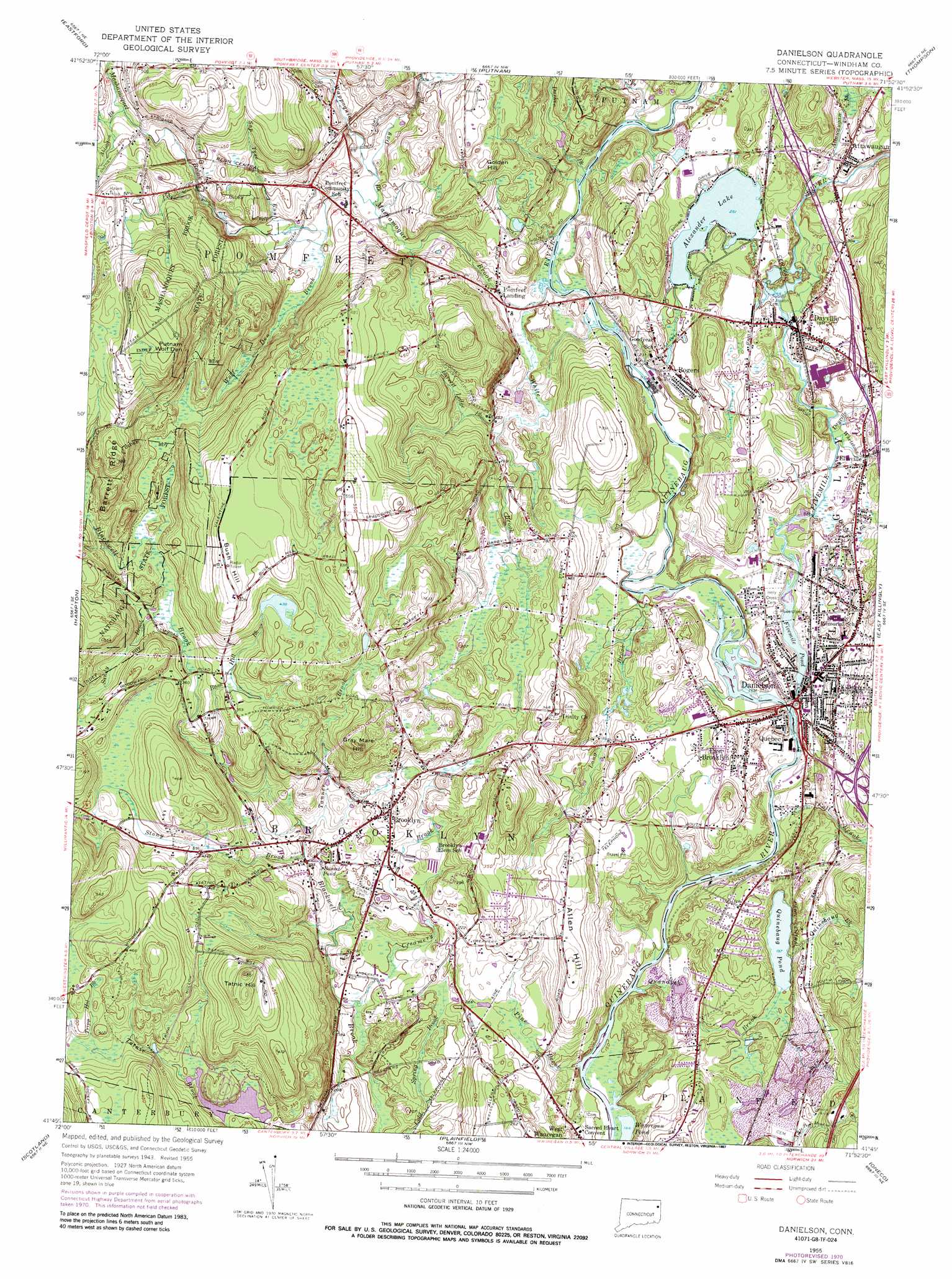
USGS Topo Quad 41071g8 - 1:24,000 scale
| Topo Map Name: | Danielson |
| USGS Topo Quad ID: | 41071g8 |
| Print Size: | ca. 21 1/4" wide x 27" high |
| Southeast Coordinates: | 41.75° N latitude / 71.875° W longitude |
| Map Center Coordinates: | 41.8125° N latitude / 71.9375° W longitude |
| U.S. State: | CT |
| Filename: | o41071g8.jpg |
| Download Map JPG Image: | Danielson topo map 1:24,000 scale |
| Map Type: | Topographic |
| Topo Series: | 7.5´ |
| Map Scale: | 1:24,000 |
| Source of Map Images: | United States Geological Survey (USGS) |
| Alternate Map Versions: |
Danielson CT 1955, updated 1958 Download PDF Buy paper map Danielson CT 1955, updated 1960 Download PDF Buy paper map Danielson CT 1955, updated 1967 Download PDF Buy paper map Danielson CT 1955, updated 1971 Download PDF Buy paper map Danielson CT 1955, updated 1987 Download PDF Buy paper map Danielson CT 1955, updated 1987 Download PDF Buy paper map Danielson CT 2012 Download PDF Buy paper map Danielson CT 2015 Download PDF Buy paper map |
1:24,000 Topo Quads surrounding Danielson
Southbridge |
Oxford |
|||
Westford |
Eastford |
Putnam |
Thompson |
Chepachet |
Spring Hill |
Hampton |
Danielson |
East Killingly |
Clayville |
Willimantic |
Scotland |
Plainfield |
Oneco |
Coventry Center |
Fitchville |
Norwich |
Jewett City |
Voluntown |
Hope Valley |
> Back to 41071e1 at 1:100,000 scale
> Back to 41070a1 at 1:250,000 scale
> Back to U.S. Topo Maps home
Danielson topo map: Gazetteer
Danielson: Airports
Danielson Airport elevation 78m 255′Wauregan Heliport elevation 70m 229′
Danielson: Bridges
Beecher Bridge elevation 58m 190′Danielson: Capes
Between the Rivers Neck elevation 78m 255′Nashawaug elevation 66m 216′
Danielson: Crossings
Interchange 91 elevation 90m 295′Interchange 93 elevation 81m 265′
Interchange 94 elevation 95m 311′
Danielson: Dams
Dyer Dam elevation 56m 183′Elmville Dam elevation 78m 255′
Fivemile Pond Dam elevation 69m 226′
Paradise Lake Dam elevation 89m 291′
Prym Manufacturing Company Dam elevation 74m 242′
Rajak Dam elevation 68m 223′
Rogers Corporation Dam elevation 68m 223′
Danielson: Forests
Lester B Williams Memorial Forest elevation 133m 436′Mashamoquet Brook State Forest elevation 173m 567′
Danielson: Lakes
Alexander Lake elevation 77m 252′Basset Pond elevation 62m 203′
Quinebaug Pond elevation 60m 196′
Wauregan Pond elevation 43m 141′
Danielson: Parks
Brooklyn Common elevation 82m 269′Brooklyn Green Historic District elevation 85m 278′
Brooklyn Recreation Park elevation 100m 328′
Bush Hill Historic District elevation 164m 538′
Davis Park elevation 77m 252′
Dayville Historic District elevation 82m 269′
Lions Park elevation 83m 272′
Mashamoquet Brook State Park elevation 188m 616′
Sap Tree Run State Park elevation 113m 370′
Danielson: Populated Places
Attawaugan elevation 99m 324′Brooklyn elevation 84m 275′
Danielson elevation 67m 219′
Dayville elevation 81m 265′
East Brooklyn elevation 84m 275′
Elmville elevation 84m 275′
Pomfret Landing elevation 73m 239′
Quebec elevation 66m 216′
Rogers elevation 79m 259′
Danielson: Post Offices
Brooklyn Post Office elevation 72m 236′Danielson Post Office elevation 69m 226′
Dayville Post Office elevation 82m 269′
Pomfret Center Post Office (historical) elevation 118m 387′
Rogers Post Office elevation 76m 249′
Danielson: Reservoirs
Bruce Ponds elevation 90m 295′Dayville Pond elevation 74m 242′
Fivemile Pond elevation 69m 226′
Paradise Lake elevation 89m 291′
Rogers Corporation Pond elevation 68m 223′
Whetstone Brook Reservoir elevation 78m 255′
Danielson: Ridges
Barrett Ridge elevation 164m 538′Danielson: Streams
Abington Brook elevation 130m 426′Attawaugan Brook elevation 90m 295′
Barrett Ledge Brook elevation 69m 226′
Bush Hill Brook elevation 78m 255′
Creamery Brook elevation 44m 144′
Davis Brook elevation 75m 246′
Day Brook elevation 80m 262′
Dayville Brook elevation 75m 246′
Durkee Brook elevation 67m 219′
Fall Brook elevation 49m 160′
Fivemile River elevation 64m 209′
Harris Brook elevation 105m 344′
James Brook elevation 60m 196′
Long Brook elevation 59m 193′
Mashamoquet Brook elevation 68m 223′
Pine Brook elevation 53m 173′
Quandock Brook elevation 44m 144′
Sandy Brook elevation 97m 318′
Sap Tree Run elevation 94m 308′
Stony Brook elevation 61m 200′
Tanner Brook elevation 59m 193′
Tripp Hollow Brook elevation 114m 374′
Wappoquia Brook elevation 80m 262′
Whetstone Brook elevation 77m 252′
White Brook elevation 65m 213′
Wolf Den Brook elevation 87m 285′
Danielson: Summits
Allen Hill elevation 104m 341′Blackwell Hill elevation 138m 452′
Bush Hill elevation 167m 547′
Golden Hill elevation 143m 469′
Gray Mare Hill elevation 139m 456′
Prince Hill elevation 133m 436′
Tatnic Hill elevation 153m 501′
Danielson digital topo map on disk
Buy this Danielson topo map showing relief, roads, GPS coordinates and other geographical features, as a high-resolution digital map file on DVD:
Maine, New Hampshire, Rhode Island & Eastern Massachusetts
Buy digital topo maps: Maine, New Hampshire, Rhode Island & Eastern Massachusetts