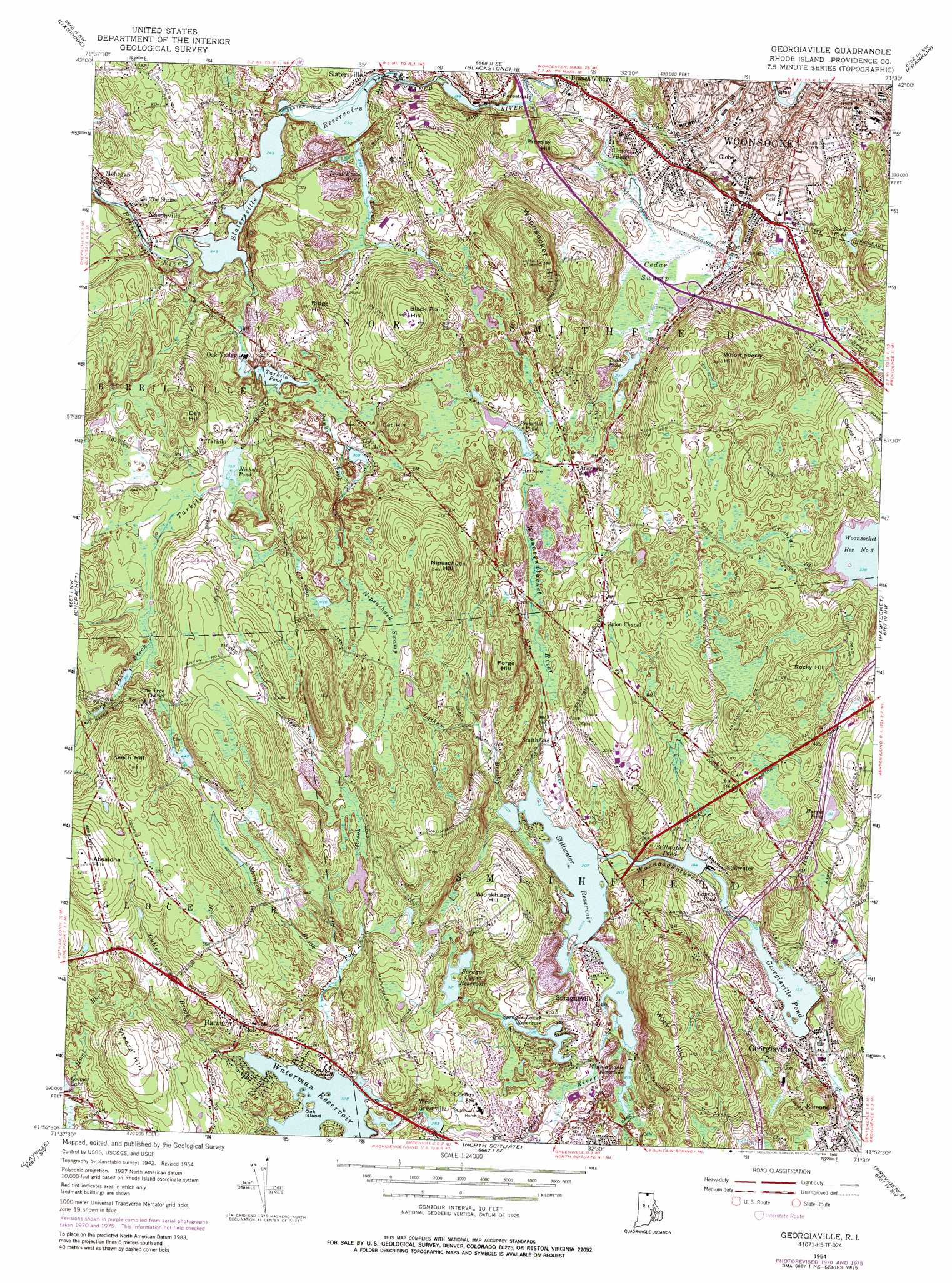
Georgiaville Topo Map Rhode Island
To zoom in, hover over the map of Georgiaville
USGS Topo Quad 41071h5 - 1:24,000 scale
| Topo Map Name: | Georgiaville |
| USGS Topo Quad ID: | 41071h5 |
| Print Size: | ca. 21 1/4" wide x 27" high |
| Southeast Coordinates: | 41.875° N latitude / 71.5° W longitude |
| Map Center Coordinates: | 41.9375° N latitude / 71.5625° W longitude |
| U.S. State: | RI |
| Filename: | o41071h5.jpg |
| Download Map JPG Image: | Georgiaville topo map 1:24,000 scale |
| Map Type: | Topographic |
| Topo Series: | 7.5´ |
| Map Scale: | 1:24,000 |
| Source of Map Images: | United States Geological Survey (USGS) |
| Alternate Map Versions: |
Georgiaville RI 1954, updated 1956 Download PDF Buy paper map Georgiaville RI 1954, updated 1969 Download PDF Buy paper map Georgiaville RI 1954, updated 1972 Download PDF Buy paper map Georgiaville RI 1954, updated 1976 Download PDF Buy paper map Georgiaville RI 1954, updated 1988 Download PDF Buy paper map Georgiaville RI 1999, updated 2000 Download PDF Buy paper map Georgiaville RI 2012 Download PDF Buy paper map Georgiaville RI 2015 Download PDF Buy paper map |
1:24,000 Topo Quads surrounding Georgiaville
Worcester South |
Milford |
Medfield |
||
Oxford |
Blackstone |
Wrentham |
||
Thompson |
Chepachet |
Georgiaville |
Attleboro |
|
East Killingly |
Clayville |
North Scituate |
East Providence |
|
Oneco |
Coventry Center |
Crompton |
East Greenwich |
Bristol |
> Back to 41071e1 at 1:100,000 scale
> Back to 41070a1 at 1:250,000 scale
> Back to U.S. Topo Maps home
Georgiaville topo map: Gazetteer
Georgiaville: Beaches
Georgiaville Beach elevation 47m 154′Mountaindale Beach elevation 80m 262′
Steers Beach elevation 102m 334′
Georgiaville: Bridges
Capron Memorial Bridge elevation 61m 200′Georgiaville: Crossings
Interchange 8 elevation 91m 298′Interchange 8A elevation 96m 314′
Interchange 8B elevation 91m 298′
Georgiaville: Dams
Curran Lower Reservoir Dam elevation 74m 242′Forestdale Pond Dam elevation 72m 236′
Georgiaville Pond Dam elevation 47m 154′
Mountaindale Reservoir Dam elevation 73m 239′
Nichols Pond Dam elevation 112m 367′
Primrose Pond Dam elevation 90m 295′
Slatersville Reservoir Middle Dam elevation 79m 259′
Slatersville Reservoir Upper Dam elevation 82m 269′
Sprague Lower Reservoir Dam elevation 72m 236′
Stillwater Pond Dam elevation 58m 190′
Stillwater Reservoir Dam elevation 68m 223′
Tarkiln Pond Dam elevation 97m 318′
Upper Sprague Reservoir Dam elevation 99m 324′
Waterman Reservoir Dam elevation 101m 331′
Georgiaville: Islands
Oak Island elevation 107m 351′Georgiaville: Lakes
Lake Bel Air elevation 94m 308′Georgiaville: Parks
Barry Field elevation 90m 295′Forestdale Mill Village Historic District elevation 79m 259′
Georgiaville Historic District elevation 54m 177′
Globe Park elevation 69m 226′
Island Place Historic District elevation 47m 154′
Market Square elevation 55m 180′
North Smithfield Wildlife Marsh elevation 69m 226′
River Island Park elevation 42m 137′
South Main Street Historic District elevation 66m 216′
Union Village Historic District elevation 92m 301′
Georgiaville: Pillars
The Blunders elevation 99m 324′Georgiaville: Populated Places
Branch Village elevation 73m 239′Field Station (historical) elevation 92m 301′
Forestdale elevation 77m 252′
Georgiaville elevation 52m 170′
Globe elevation 65m 213′
Harmony elevation 129m 423′
Mohegan elevation 100m 328′
Nasonville elevation 92m 301′
North Smithfield elevation 111m 364′
Oak Valley elevation 82m 269′
Primrose elevation 89m 291′
Smithfield elevation 84m 275′
Spragueville elevation 77m 252′
Stillwater elevation 69m 226′
Tarkiln elevation 126m 413′
Union Village elevation 80m 262′
West Greenville elevation 98m 321′
Georgiaville: Post Offices
Smithfield Post Office elevation 68m 223′Georgiaville: Reservoirs
Booth Pond elevation 92m 301′Capron Pond elevation 51m 167′
Curran Lower Reservoir elevation 74m 242′
Forestdale Pond elevation 69m 226′
Georgiaville Pond elevation 47m 154′
Harris Pond elevation 94m 308′
Mountaindale Reservoir elevation 73m 239′
Nichols Pond elevation 112m 367′
Primrose Pond elevation 90m 295′
Slatersville Reservoir Upper elevation 82m 269′
Slatersville Reservoirs elevation 76m 249′
Slattersville Reservoir elevation 79m 259′
Sprague Lower Reservoir elevation 72m 236′
Sprague Upper Reservoir elevation 100m 328′
Stillwater Pond elevation 58m 190′
Stillwater Reservoir elevation 68m 223′
Tarkiln Pond elevation 97m 318′
Todds Pond elevation 73m 239′
Trout Brook Pond elevation 70m 229′
Upper Slatersville Reservoir elevation 76m 249′
Upper Sprague Reservoir elevation 99m 324′
Waterman Reservoir elevation 101m 331′
Georgiaville: Springs
Boiling Spring elevation 130m 426′Georgiaville: Streams
Airport Creek elevation 101m 331′Cutler Brook elevation 102m 334′
Dawley Brook elevation 65m 213′
Gould Brook elevation 48m 157′
Hanton Brook elevation 65m 213′
Harris Brook elevation 53m 173′
Hunt Brook elevation 126m 413′
Latham Brook elevation 67m 219′
Mattetee Swamp Brook elevation 84m 275′
Mowry Paine Brook elevation 123m 403′
Nine Foot Brook elevation 106m 347′
Rankin Brook elevation 96m 314′
Reaper Brook elevation 70m 229′
Shinscot Brook elevation 110m 360′
Sprague Brook elevation 77m 252′
Stillwater River elevation 63m 206′
Tarkiln Brook elevation 80m 262′
Trout Brook elevation 70m 229′
Whipple Brook elevation 47m 154′
Georgiaville: Summits
Absalona Hill elevation 198m 649′Black Plain Hill elevation 150m 492′
Cat Hill elevation 129m 423′
Den Hill elevation 157m 515′
Forge Hill elevation 135m 442′
Keech Hill elevation 194m 636′
Logee Hill elevation 115m 377′
Nipsachuck Hill elevation 167m 547′
Premisy Hill elevation 111m 364′
Ridge Hill elevation 124m 406′
Rocky Hill elevation 156m 511′
Sayles Hill elevation 143m 469′
Steere Hill elevation 172m 564′
Whortleberry Hill elevation 169m 554′
Wionkhiege Hill elevation 143m 469′
Wolf Hill elevation 144m 472′
Woonsocket Hill elevation 180m 590′
Georgiaville: Swamps
Cedar Swamp elevation 70m 229′Mattetokomitt Swamp elevation 93m 305′
Nipsachuck Swamp elevation 131m 429′
Georgiaville digital topo map on disk
Buy this Georgiaville topo map showing relief, roads, GPS coordinates and other geographical features, as a high-resolution digital map file on DVD:
Maine, New Hampshire, Rhode Island & Eastern Massachusetts
Buy digital topo maps: Maine, New Hampshire, Rhode Island & Eastern Massachusetts