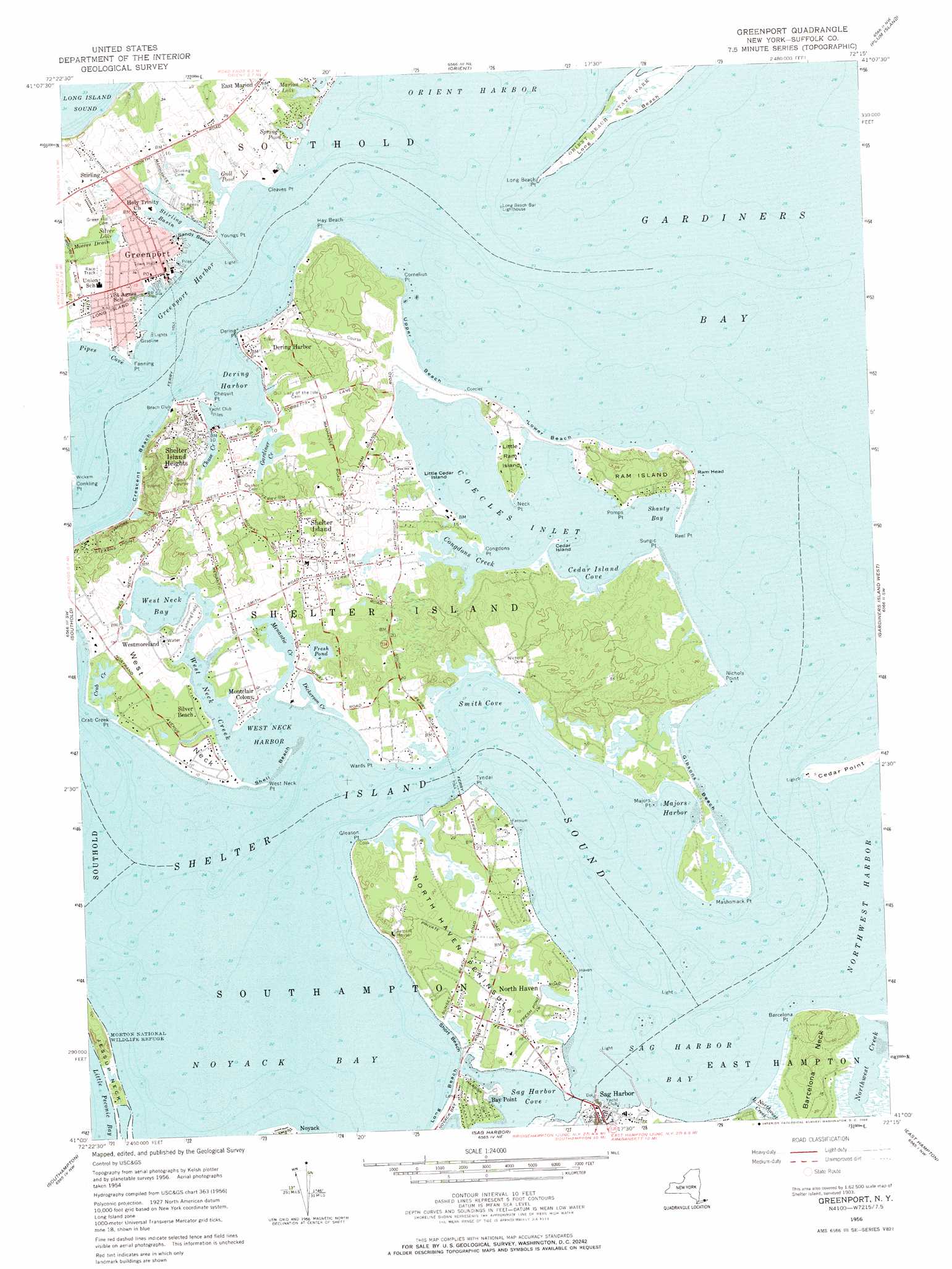
Greenport Topo Map New York
To zoom in, hover over the map of Greenport
USGS Topo Quad 41072a3 - 1:24,000 scale
| Topo Map Name: | Greenport |
| USGS Topo Quad ID: | 41072a3 |
| Print Size: | ca. 21 1/4" wide x 27" high |
| Southeast Coordinates: | 41° N latitude / 72.25° W longitude |
| Map Center Coordinates: | 41.0625° N latitude / 72.3125° W longitude |
| U.S. State: | NY |
| Filename: | o41072a3.jpg |
| Download Map JPG Image: | Greenport topo map 1:24,000 scale |
| Map Type: | Topographic |
| Topo Series: | 7.5´ |
| Map Scale: | 1:24,000 |
| Source of Map Images: | United States Geological Survey (USGS) |
| Alternate Map Versions: |
Greenport NY 1947 Download PDF Buy paper map Greenport NY 1956, updated 1958 Download PDF Buy paper map Greenport NY 1956, updated 1969 Download PDF Buy paper map Greenport NY 1956, updated 1969 Download PDF Buy paper map Greenport NY 2010 Download PDF Buy paper map Greenport NY 2013 Download PDF Buy paper map Greenport NY 2016 Download PDF Buy paper map |
1:24,000 Topo Quads surrounding Greenport
Clinton |
Essex |
Old Lyme |
Niantic |
New London |
Orient |
Plum Island |
|||
Mattituck Hills |
Southold |
Greenport |
Gardiners Island West |
Gardiners Island East |
Mattituck |
Southampton |
Sag Harbor |
East Hampton |
Napeague Beach |
Quogue |
Shinnecock Inlet |
> Back to 41072a1 at 1:100,000 scale
> Back to 41072a1 at 1:250,000 scale
> Back to U.S. Topo Maps home
Greenport topo map: Gazetteer
Greenport: Airports
Eastern Long Island Heliport elevation 0m 0′Greenport: Bars
Sand Spit elevation 0m 0′Greenport: Bays
Cedar Island Cove elevation 0m 0′Coecles Harbor elevation 0m 0′
Congdons Creek elevation 0m 0′
Crab Creek elevation 0m 0′
Dering Harbor elevation 0m 0′
Dickerson Creek elevation 0m 0′
Greenport Harbor elevation 0m 0′
Gull Pond elevation 0m 0′
Majors Harbor elevation 0m 0′
Menantic Creek elevation 0m 0′
Northwest Harbor elevation 0m 0′
Noyack Bay elevation 0m 0′
Sag Harbor Bay elevation 0m 0′
Sag Harbor Cove elevation 0m 0′
Shanty Bay elevation 0m 0′
Shelter Island Sound elevation 0m 0′
Short Bay elevation 0m 0′
Smith Cove elevation 0m 0′
Spring Pond elevation 0m 0′
Stirling Basin elevation 0m 0′
West Neck Bay elevation 0m 0′
West Neck Harbor elevation 0m 0′
Greenport: Beaches
Crescent Beach elevation 0m 0′Gibsons Beach elevation 0m 0′
Long Beach elevation 0m 0′
Lower Beach elevation 0m 0′
Sandy Beach elevation 0m 0′
Shell Beach elevation 0m 0′
Short Beach elevation 0m 0′
Upper Beach elevation 0m 0′
Greenport: Capes
Barcelona Neck elevation 12m 39′Barcelona Point elevation 5m 16′
Cedar Point elevation 4m 13′
Chequit Point elevation 2m 6′
Cleaves Point elevation 1m 3′
Congdons Point elevation 0m 0′
Cornelius Point elevation 3m 9′
Crab Creek Point elevation 0m 0′
Dering Point elevation 2m 6′
Fanning Point elevation 0m 0′
Gleason Point elevation 3m 9′
Hay Beach Point elevation 1m 3′
Jessup Neck elevation 3m 9′
Long Beach Point elevation 1m 3′
Majors Point elevation 0m 0′
Mashomack Point elevation 2m 6′
Neck Point elevation 0m 0′
Nicoll Point elevation 0m 0′
North Haven Peninsula elevation 3m 9′
Pomps Point elevation 1m 3′
Reel Point elevation 1m 3′
Sungic Point elevation 2m 6′
Tyndal Point elevation 0m 0′
Wards Point elevation 7m 22′
West Neck elevation 3m 9′
West Neck Point elevation 0m 0′
Youngs Point elevation 0m 0′
Greenport: Cliffs
Ram Head elevation 0m 0′Greenport: Guts
Gardiners Creek elevation 2m 6′Greenport: Harbors
Greenport Basin elevation 0m 0′Greenport: Islands
Cedar Island elevation 1m 3′Little Cedar Island elevation 0m 0′
Little Ram Island elevation 3m 9′
Ram Island elevation 9m 29′
Shelter Island elevation 5m 16′
Greenport: Lakes
Fresh Pond elevation 1m 3′Silver Lake elevation 1m 3′
Greenport: Levees
Gardiners Bay Country Club elevation 16m 52′Greenport: Parks
Greenport Village Historic District elevation 3m 9′Mashomack Preserve elevation 15m 49′
Morton National Wildlife Refuge elevation 1m 3′
Shelter Island Heights Historic District elevation 17m 55′
Greenport: Populated Places
Bay Point elevation 8m 26′Dering Harbor elevation 2m 6′
Greenport elevation 3m 9′
Greenport Homes elevation 5m 16′
Montclair Colony elevation 3m 9′
North Haven elevation 6m 19′
Shelter Island elevation 16m 52′
Shelter Island Heights elevation 17m 55′
Silver Beach elevation 3m 9′
Stirling elevation 5m 16′
Westmoreland elevation 5m 16′
Greenport: Post Offices
Greenport Post Office elevation 2m 6′Greenport: Ranges
South Ferry Hills elevation 3m 9′Greenport: Streams
Chase Creek elevation 1m 3′Little Northwest Creek elevation 0m 0′
West Neck Creek elevation 0m 0′
Greenport digital topo map on disk
Buy this Greenport topo map showing relief, roads, GPS coordinates and other geographical features, as a high-resolution digital map file on DVD:
New York, Vermont, Connecticut & Western Massachusetts
Buy digital topo maps: New York, Vermont, Connecticut & Western Massachusetts