Orient Topo Map New York
To zoom in, hover over the map of Orient
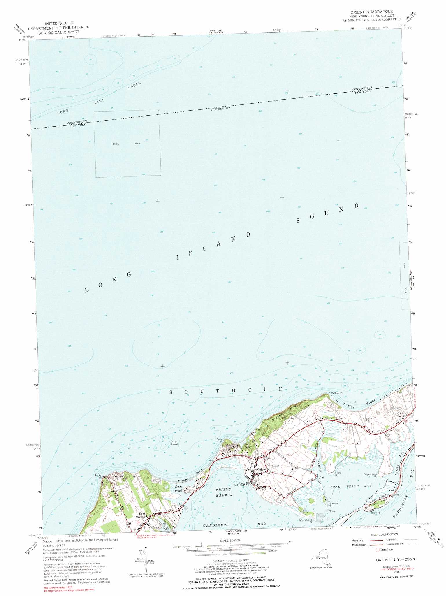
USGS Topo Quad 41072b3 - 1:24,000 scale
| Topo Map Name: | Orient |
| USGS Topo Quad ID: | 41072b3 |
| Print Size: | ca. 21 1/4" wide x 27" high |
| Southeast Coordinates: | 41.125° N latitude / 72.25° W longitude |
| Map Center Coordinates: | 41.1875° N latitude / 72.3125° W longitude |
| U.S. States: | NY, CT |
| Filename: | o41072b3.jpg |
| Download Map JPG Image: | Orient topo map 1:24,000 scale |
| Map Type: | Topographic |
| Topo Series: | 7.5´ |
| Map Scale: | 1:24,000 |
| Source of Map Images: | United States Geological Survey (USGS) |
| Alternate Map Versions: |
Orient NY 1947 Download PDF Buy paper map Orient NY 1956, updated 1957 Download PDF Buy paper map Orient NY 1956, updated 1974 Download PDF Buy paper map Orient NY 1956, updated 1985 Download PDF Buy paper map Orient NY 2010 Download PDF Buy paper map Orient NY 2013 Download PDF Buy paper map Orient NY 2016 Download PDF Buy paper map |
1:24,000 Topo Quads surrounding Orient
Haddam |
Deep River |
Hamburg |
Montville |
Uncasville |
Clinton |
Essex |
Old Lyme |
Niantic |
New London |
Orient |
Plum Island |
|||
Mattituck Hills |
Southold |
Greenport |
Gardiners Island West |
Gardiners Island East |
Mattituck |
Southampton |
Sag Harbor |
East Hampton |
Napeague Beach |
> Back to 41072a1 at 1:100,000 scale
> Back to 41072a1 at 1:250,000 scale
> Back to U.S. Topo Maps home
Orient topo map: Gazetteer
Orient: Airports
Rose Field elevation 1m 3′Orient: Bars
Orient Shoal elevation 0m 0′Orient: Bays
Little Bay elevation 0m 0′Long Beach Bay elevation 0m 0′
Orient Harbor elevation 0m 0′
Pettys Bight elevation 0m 0′
Orient: Beaches
Orient Beach elevation 2m 6′Truman Beach elevation 2m 6′
Orient: Capes
Bens Point elevation 1m 3′Browns Point elevation 0m 0′
Eagle Point elevation 0m 0′
Eagles Neck Point elevation 0m 0′
Mulford Point elevation 5m 16′
Peters Neck Point elevation 1m 3′
Rocky Point elevation 17m 55′
Terry Point elevation 3m 9′
Orient: Lakes
Marion Lake elevation 0m 0′Munn Lake elevation 2m 6′
Orient: Parks
Orient Beach State Park elevation 1m 3′Orient Historic District elevation 5m 16′
Orient: Populated Places
East Marion elevation 10m 32′Orient elevation 4m 13′
Orient Point elevation 3m 9′
Orient: Reservoirs
Dam Pond elevation 0m 0′Orient: Streams
Narrow River elevation 0m 0′Orient: Summits
Browns Hills elevation 26m 85′Orient digital topo map on disk
Buy this Orient topo map showing relief, roads, GPS coordinates and other geographical features, as a high-resolution digital map file on DVD:
New York, Vermont, Connecticut & Western Massachusetts
Buy digital topo maps: New York, Vermont, Connecticut & Western Massachusetts