Old Lyme Topo Map Connecticut
To zoom in, hover over the map of Old Lyme
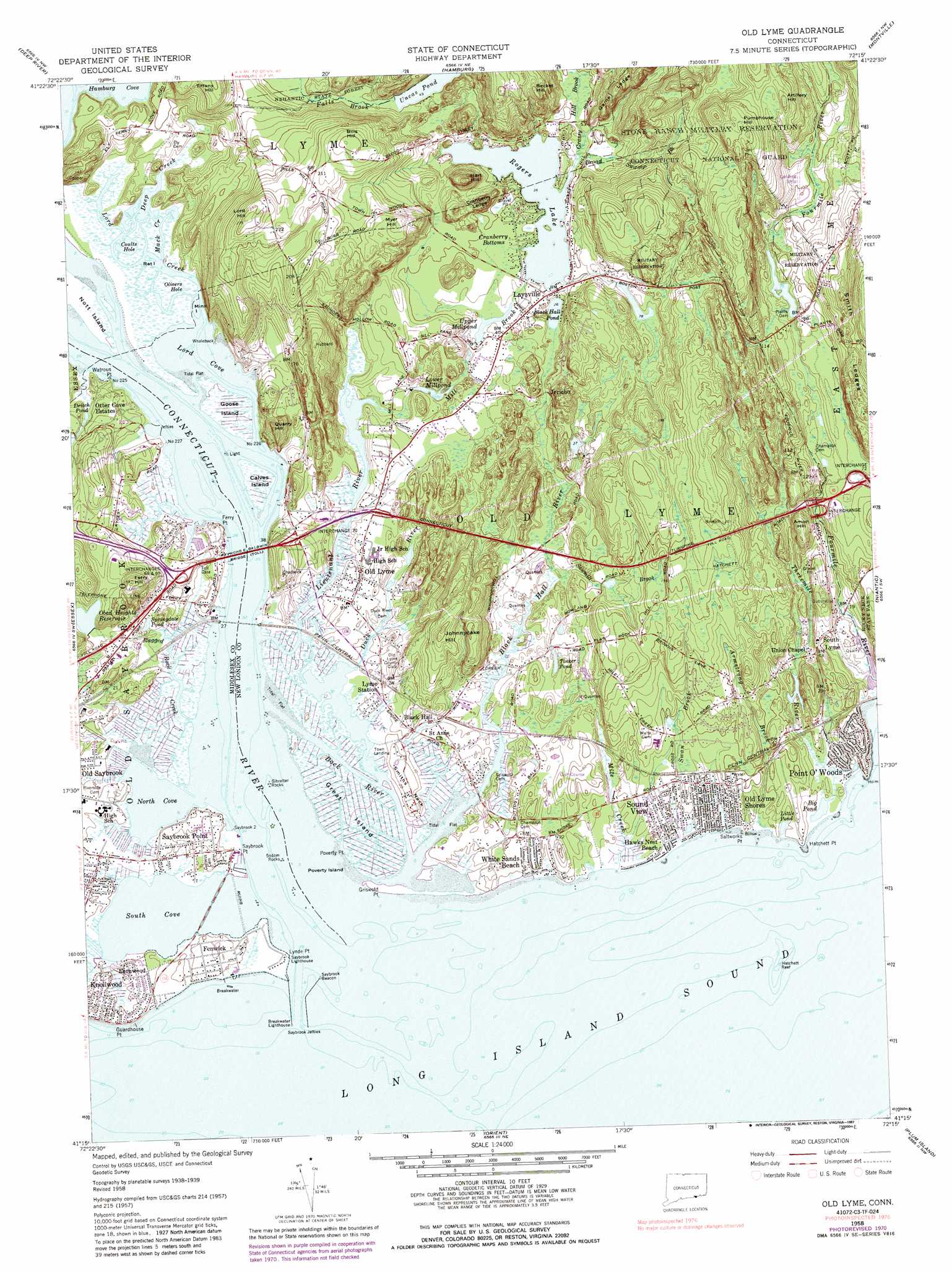
USGS Topo Quad 41072c3 - 1:24,000 scale
| Topo Map Name: | Old Lyme |
| USGS Topo Quad ID: | 41072c3 |
| Print Size: | ca. 21 1/4" wide x 27" high |
| Southeast Coordinates: | 41.25° N latitude / 72.25° W longitude |
| Map Center Coordinates: | 41.3125° N latitude / 72.3125° W longitude |
| U.S. State: | CT |
| Filename: | o41072c3.jpg |
| Download Map JPG Image: | Old Lyme topo map 1:24,000 scale |
| Map Type: | Topographic |
| Topo Series: | 7.5´ |
| Map Scale: | 1:24,000 |
| Source of Map Images: | United States Geological Survey (USGS) |
| Alternate Map Versions: |
Old Lyme CT 1958, updated 1959 Download PDF Buy paper map Old Lyme CT 1958, updated 1966 Download PDF Buy paper map Old Lyme CT 1958, updated 1971 Download PDF Buy paper map Old Lyme CT 1958, updated 1980 Download PDF Buy paper map Old Lyme CT 1958, updated 1987 Download PDF Buy paper map Old Lyme CT 1958, updated 1987 Download PDF Buy paper map Old Lyme CT 2012 Download PDF Buy paper map Old Lyme CT 2015 Download PDF Buy paper map |
1:24,000 Topo Quads surrounding Old Lyme
Middle Haddam |
Moodus |
Colchester |
Fitchville |
Norwich |
Haddam |
Deep River |
Hamburg |
Montville |
Uncasville |
Clinton |
Essex |
Old Lyme |
Niantic |
New London |
Orient |
Plum Island |
|||
Mattituck Hills |
Southold |
Greenport |
Gardiners Island West |
Gardiners Island East |
> Back to 41072a1 at 1:100,000 scale
> Back to 41072a1 at 1:250,000 scale
> Back to U.S. Topo Maps home
Old Lyme topo map: Gazetteer
Old Lyme: Airports
Lord Creek Seaplane Base elevation 0m 0′Old Saybrook Heliport elevation 13m 42′
Old Lyme: Bars
Calves Island Bar elevation 0m 0′Gibralter Rocks elevation 0m 0′
Hatchett Reef elevation 0m 0′
Saybrook Breakwater elevation 0m 0′
Saybrook Outer Bar elevation 0m 0′
Saybrook Shoal elevation 0m 0′
Old Lyme: Bays
Coults Hole elevation 0m 0′Griswold Cove elevation 0m 0′
Hamburg Cove elevation 0m 0′
Lord Cove elevation 0m 0′
North Cove elevation 0m 0′
Olivers Hole elevation 0m 0′
Pug Harbor elevation 1m 3′
South Cove elevation 0m 0′
Old Lyme: Beaches
Poverty Island Beach elevation 2m 6′Soundview Beach elevation 1m 3′
Old Lyme: Benches
Cranberry Ledge elevation 20m 65′Game Ledge elevation 53m 173′
Smith Ledges elevation 51m 167′
Old Lyme: Bends
Cranberry Bottoms elevation 14m 45′Old Lyme: Bridges
Great Bridge elevation 11m 36′Raymond E Baldwin Bridge elevation 0m 0′
Old Lyme: Capes
Ayers Point elevation 1m 3′Ferry Point elevation 0m 0′
Griswold Point elevation 1m 3′
Guardhouse Point elevation 7m 22′
Hatchett Point elevation 5m 16′
Lynde Point elevation 0m 0′
Poverty Point elevation 7m 22′
Saltworks Point elevation 0m 0′
Saybrook Point elevation 0m 0′
Smiths Neck elevation 3m 9′
Watrous Point elevation 0m 0′
Yacht Club Point elevation 0m 0′
Old Lyme: Channels
Back River elevation 2m 6′Calves Island Bar Channel elevation 0m 0′
Saybrook Outer Bar Channel elevation 0m 0′
Saybrook Outer Bar Channel elevation 0m 0′
Saybrook Shoal Channel elevation 0m 0′
Old Lyme: Crossings
Interchange 68 elevation 3m 9′Interchange 69 elevation 0m 0′
Interchange 70 elevation 20m 65′
Interchange 71 elevation 23m 75′
Interchange Seventy-two elevation 32m 104′
Old Lyme: Dams
East Jetty elevation 0m 0′Obed Heights Reservoir Dam elevation 22m 72′
Plants Dam elevation 23m 75′
Rogers Lake Dam elevation 13m 42′
West Jetty elevation 0m 0′
Old Lyme: Islands
Calves Island elevation 5m 16′Calves Island Bar elevation 0m 0′
Goose Island elevation 1m 3′
Great Island elevation 4m 13′
Ingraham Rocks elevation 0m 0′
Marvin Island elevation 0m 0′
Mink Island elevation 0m 0′
Nott Island elevation 3m 9′
Poverty Island elevation 0m 0′
Rat Island elevation 0m 0′
Old Lyme: Lakes
Big Pond elevation 0m 0′Black Hall Pond elevation 20m 65′
Deitch Pond elevation 13m 42′
Little Pond elevation 4m 13′
Springdale Pond elevation 6m 19′
Tinker Pond elevation 8m 26′
Uncas Pond elevation 15m 49′
Old Lyme: Parks
Beckett Hill State Park Reserve elevation 68m 223′Cross Lane Recreation Area elevation 11m 36′
Fort Saybrook Monument Park elevation 8m 26′
Gardner Statue elevation 10m 32′
Great Island Nature Area elevation 2m 6′
Hains Park elevation 16m 52′
Old Lyme Green elevation 8m 26′
Old Lyme Historic District elevation 8m 26′
Old Lyme: Pillars
Gilbralter Rocks elevation 0m 0′Sodom Rocks elevation 0m 0′
Yale Boulder elevation 8m 26′
Old Lyme: Populated Places
Black Hall elevation 6m 19′Fenwick elevation 9m 29′
Fenwood elevation 8m 26′
Floral Park elevation 9m 29′
Hawks Nest Beach elevation 6m 19′
Jericho elevation 33m 108′
Laysville elevation 14m 45′
Lyme Station elevation 5m 16′
Miami Shores elevation 4m 13′
Old Lyme elevation 8m 26′
Old Lyme Shores elevation 10m 32′
Otter Cove Estates elevation 10m 32′
Point O'Woods elevation 10m 32′
Saybrook Point elevation 9m 29′
Sound View elevation 8m 26′
South Lyme elevation 16m 52′
Town Landing elevation 3m 9′
White Sands Beach elevation 10m 32′
Old Lyme: Post Offices
Old Lyme Post Office elevation 12m 39′South Lyme Post Office elevation 11m 36′
Old Lyme: Reservoirs
Goodwins Pond elevation 23m 75′Lower Millpond elevation 13m 42′
Obed Heights Reservoir elevation 22m 72′
Rogers Lake elevation 13m 42′
Swan Pond elevation 2m 6′
Upper Millpond elevation 12m 39′
Old Lyme: Streams
Armstrong Brook elevation 3m 9′Beamon Creek elevation 2m 6′
Broad Swamp Brook elevation 14m 45′
Connecticut River elevation 0m 0′
Deep Creek elevation 0m 0′
Duck River elevation 4m 13′
Grassy Hill Brook elevation 19m 62′
Lieutenant River elevation 0m 0′
Lord Creek elevation 8m 26′
Mack Creek elevation 0m 0′
Mile Creek elevation 0m 0′
Mill Brook elevation 0m 0′
Ragged Rock Creek elevation 0m 0′
Sawmill Brook elevation 2m 6′
Swan Brook elevation 4m 13′
Threemile River elevation 3m 9′
Old Lyme: Summits
Amon Hill elevation 43m 141′Artillery Hill elevation 76m 249′
Becket Hill elevation 58m 190′
Bills Hill elevation 78m 255′
Ely Hill elevation 32m 104′
Ferry Hill elevation 46m 150′
Hart Hill elevation 28m 91′
Johnnycake Hill elevation 48m 157′
Lord Hill elevation 83m 272′
Meeting House Hill elevation 9m 29′
Myer Hill elevation 64m 209′
Pumphouse Hill elevation 86m 282′
Quarry Hill elevation 31m 101′
Old Lyme: Swamps
Ely Meadow elevation 0m 0′Gunning Swamp elevation 3m 9′
Old Lyme digital topo map on disk
Buy this Old Lyme topo map showing relief, roads, GPS coordinates and other geographical features, as a high-resolution digital map file on DVD:
New York, Vermont, Connecticut & Western Massachusetts
Buy digital topo maps: New York, Vermont, Connecticut & Western Massachusetts