Essex Topo Map Connecticut
To zoom in, hover over the map of Essex
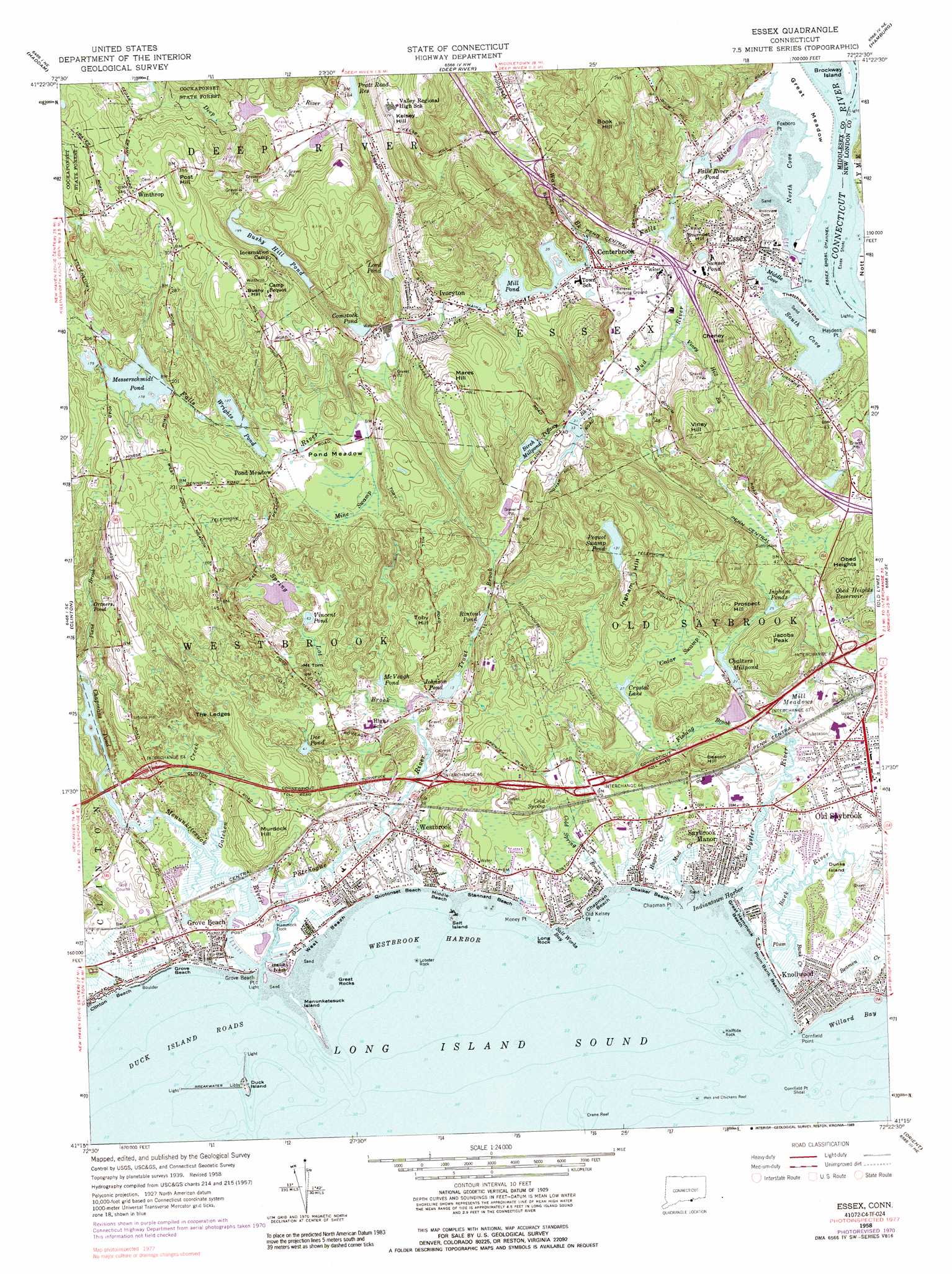
USGS Topo Quad 41072c4 - 1:24,000 scale
| Topo Map Name: | Essex |
| USGS Topo Quad ID: | 41072c4 |
| Print Size: | ca. 21 1/4" wide x 27" high |
| Southeast Coordinates: | 41.25° N latitude / 72.375° W longitude |
| Map Center Coordinates: | 41.3125° N latitude / 72.4375° W longitude |
| U.S. State: | CT |
| Filename: | o41072c4.jpg |
| Download Map JPG Image: | Essex topo map 1:24,000 scale |
| Map Type: | Topographic |
| Topo Series: | 7.5´ |
| Map Scale: | 1:24,000 |
| Source of Map Images: | United States Geological Survey (USGS) |
| Alternate Map Versions: |
Essex CT 1958, updated 1960 Download PDF Buy paper map Essex CT 1958, updated 1968 Download PDF Buy paper map Essex CT 1958, updated 1971 Download PDF Buy paper map Essex CT 1958, updated 1983 Download PDF Buy paper map Essex CT 1958, updated 1989 Download PDF Buy paper map Essex CT 2012 Download PDF Buy paper map Essex CT 2015 Download PDF Buy paper map |
1:24,000 Topo Quads surrounding Essex
Middletown |
Middle Haddam |
Moodus |
Colchester |
Fitchville |
Durham |
Haddam |
Deep River |
Hamburg |
Montville |
Guilford |
Clinton |
Essex |
Old Lyme |
Niantic |
Orient |
Plum Island |
|||
Mattituck Hills |
Southold |
Greenport |
Gardiners Island West |
> Back to 41072a1 at 1:100,000 scale
> Back to 41072a1 at 1:250,000 scale
> Back to U.S. Topo Maps home
Essex topo map: Gazetteer
Essex: Airports
Old Saybrook Police Heliport elevation 12m 39′Shoreline Clinic Heliport elevation 16m 52′
Essex: Bars
Cornfield Point Shoal elevation 0m 0′Crane Reef elevation 0m 0′
Essex Shoal elevation 0m 0′
Hen and Chickens Reef elevation 0m 0′
Essex: Bays
Duck Island Roads elevation 0m 0′Indiantown Harbor elevation 0m 0′
Middle Cove elevation 0m 0′
North Cove elevation 0m 0′
Salt Works Bay elevation 0m 0′
South Cove elevation 0m 0′
Westbrook Harbor elevation 0m 0′
Willard Bay elevation 0m 0′
Essex: Beaches
Chalker Beach elevation 1m 3′Chapman Beach elevation 0m 0′
Chapman Strand (historical) elevation 1m 3′
Clinton Beach elevation 1m 3′
Great Hammock Beach elevation 0m 0′
Grove Beach elevation 3m 9′
Harveys Beach elevation 0m 0′
Indiantown Beach elevation 1m 3′
Middle Beach elevation 3m 9′
Plum Bank Beach elevation 5m 16′
Quotonset Beach elevation 1m 3′
Stannard Beach elevation 2m 6′
West Beach elevation 0m 0′
Essex: Benches
The Ledges elevation 32m 104′Essex: Capes
Chapman Point elevation 1m 3′Cornfield Point elevation 0m 0′
Foxboro Point elevation 0m 0′
Grove Beach Point elevation 0m 0′
Haydens Point elevation 11m 36′
Money Point elevation 6m 19′
Old Kelsey Point elevation 3m 9′
Pilots Point elevation 0m 0′
Potopaug Point elevation 9m 29′
Essex: Channels
Essex Shoal Channel elevation 0m 0′Essex: Crossings
Interchange 2 elevation 28m 91′Interchange 3 elevation 11m 36′
Interchange 4 elevation 15m 49′
Interchange 64 elevation 21m 68′
Interchange 65 elevation 15m 49′
Interchange 66 elevation 13m 42′
Interchange 67 elevation 7m 22′
Essex: Dams
Birch Millpond Dam elevation 20m 65′Comstock Pond Dam elevation 30m 98′
Duck Island Breakwaters elevation 0m 0′
Johnson Pond Dam elevation 6m 19′
Messerschmidt Pond Dam elevation 52m 170′
Mill Pond Dam elevation 18m 59′
Wrights Pond Dam elevation 37m 121′
Essex: Flats
Great Meadow elevation 0m 0′Essex: Islands
Brockway Island elevation 0m 0′Duck Island elevation 1m 3′
Dunks Island elevation 6m 19′
Great Rocks elevation 0m 0′
Halftide Rock elevation 0m 0′
Lobster Rock elevation 0m 0′
Long Rock elevation 0m 0′
Menunketesuck Island elevation 0m 0′
Salt Island elevation 0m 0′
Thatchbed Island elevation 0m 0′
Essex: Lakes
Chapmans Pond elevation 3m 9′Dee Pond elevation 13m 42′
McVeagh Pond elevation 8m 26′
Ortners Pond elevation 31m 101′
Pequot Swamp Pond elevation 44m 144′
Sunset Pond elevation 19m 62′
Essex: Parks
Clark Memorial Field elevation 2m 6′Crystal Lake Town Park elevation 14m 45′
Essex Square elevation 20m 65′
Essex Town Park elevation 11m 36′
Old Saybrook South Green elevation 12m 39′
Old Saybrook Town Green elevation 9m 29′
Plattwood Park elevation 38m 124′
Salt Meadow National Wildlife Refuge elevation 22m 72′
Trask Town Park elevation 9m 29′
Essex: Populated Places
Centerbrook elevation 16m 52′Chapman (historical) elevation 0m 0′
Cornfield Park elevation 9m 29′
Essex elevation 17m 55′
Grove Beach elevation 5m 16′
Hawks Nest elevation 6m 19′
Ivoryton elevation 23m 75′
Knollwood elevation 11m 36′
Old Saybrook elevation 9m 29′
Plum Bank Beach elevation 6m 19′
Pond Meadow elevation 46m 150′
Saybrook Manor elevation 12m 39′
Westbrook elevation 11m 36′
Winthrop elevation 105m 344′
Essex: Post Offices
Centerbrook Post Office elevation 14m 45′Ivoryton Post Office elevation 24m 78′
Old Saybrook Post Office elevation 13m 42′
Westbrook Post Office elevation 10m 32′
Essex: Reservoirs
Birch Millpond elevation 20m 65′Bushy Hill Pond elevation 65m 213′
Chalkers Millpond elevation 14m 45′
Comstock Pond elevation 30m 98′
Cranberry Pond elevation 21m 68′
Crystal Lake elevation 17m 55′
Falls River Pond elevation 0m 0′
Ingham Ponds elevation 8m 26′
Johnson Pond elevation 6m 19′
Lake Rockview elevation 2m 6′
Lord Pond elevation 46m 150′
Messerschmidt Pond elevation 52m 170′
Mill Pond elevation 21m 68′
Rintoul Pond elevation 20m 65′
Vincent Pond elevation 20m 65′
Wrights Pond elevation 37m 121′
Essex: Ridges
Hawks Nest elevation 6m 19′Essex: Springs
Cold Spring elevation 17m 55′Essex: Streams
Back River elevation 0m 0′Cold Spring Brook elevation 0m 0′
Eightmile River elevation 0m 0′
Falls River elevation 0m 0′
Fishing Brook elevation 4m 13′
Gatchen Creek elevation 0m 0′
Hagar Creek elevation 0m 0′
Menunketesuck River elevation 0m 0′
Mud Creek elevation 0m 0′
Mud River elevation 20m 65′
Oyster River elevation 0m 0′
Patchogue River elevation 0m 0′
Plane Brook elevation 10m 32′
Plum Bank Creek elevation 0m 0′
Spring Lot Brook elevation 1m 3′
Tiffany Brook elevation 5m 16′
Trout Brook elevation 13m 42′
Viney Hill Brook elevation 13m 42′
Ward Brook elevation 13m 42′
Essex: Summits
Beacon Hill elevation 27m 88′Book Hill elevation 85m 278′
Bushy Hill elevation 105m 344′
Cheney Hill elevation 63m 206′
Ingham Hill elevation 48m 157′
Jacobs Peak elevation 55m 180′
Kelsey Hill elevation 80m 262′
Mares Hill elevation 79m 259′
Mount Tom elevation 34m 111′
Murdock Hill elevation 35m 114′
Obed Heights elevation 60m 196′
Orchard Hill elevation 94m 308′
Post Hill elevation 101m 331′
Prospect Hill elevation 66m 216′
Stumpet Hill elevation 51m 167′
Toby Hill elevation 51m 167′
Viney Hill elevation 62m 203′
Essex: Swamps
Cedar Swamp elevation 13m 42′Mill Meadows elevation 9m 29′
Mine Swamp elevation 38m 124′
Pequot Swamp elevation 40m 131′
Pond Meadow elevation 39m 127′
Essex digital topo map on disk
Buy this Essex topo map showing relief, roads, GPS coordinates and other geographical features, as a high-resolution digital map file on DVD:
New York, Vermont, Connecticut & Western Massachusetts
Buy digital topo maps: New York, Vermont, Connecticut & Western Massachusetts