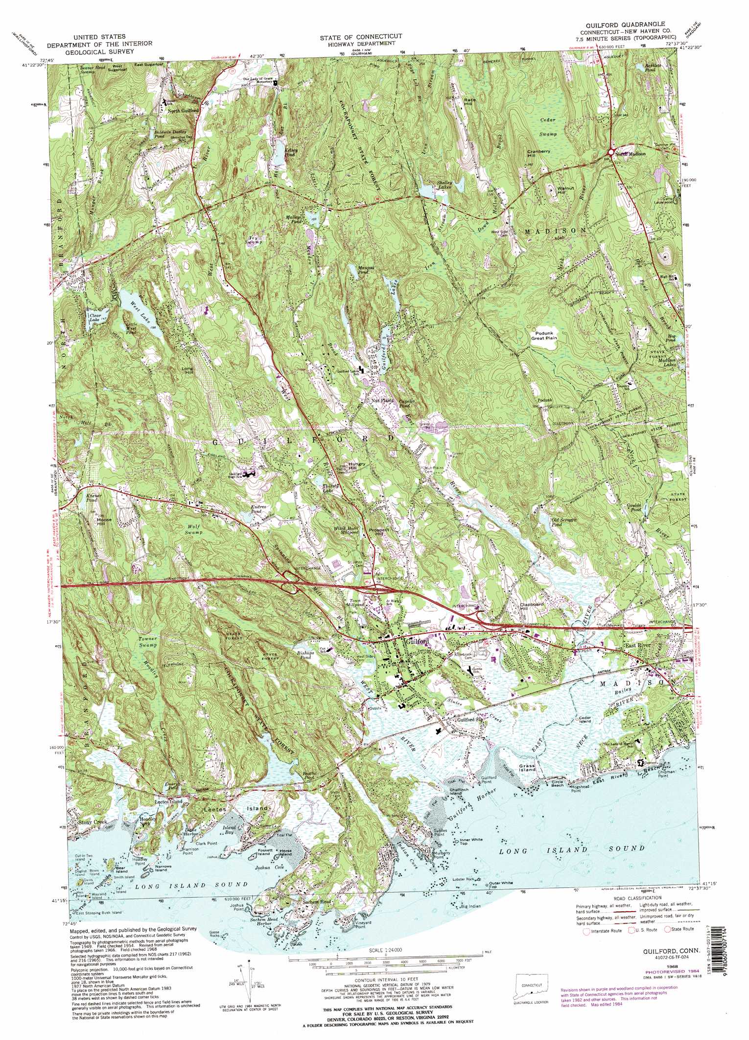
Guilford Topo Map Connecticut
To zoom in, hover over the map of Guilford
USGS Topo Quad 41072c6 - 1:24,000 scale
| Topo Map Name: | Guilford |
| USGS Topo Quad ID: | 41072c6 |
| Print Size: | ca. 21 1/4" wide x 27" high |
| Southeast Coordinates: | 41.25° N latitude / 72.625° W longitude |
| Map Center Coordinates: | 41.3125° N latitude / 72.6875° W longitude |
| U.S. State: | CT |
| Filename: | o41072c6.jpg |
| Download Map JPG Image: | Guilford topo map 1:24,000 scale |
| Map Type: | Topographic |
| Topo Series: | 7.5´ |
| Map Scale: | 1:24,000 |
| Source of Map Images: | United States Geological Survey (USGS) |
| Alternate Map Versions: |
Guilford CT 1954, updated 1959 Download PDF Buy paper map Guilford CT 1954, updated 1960 Download PDF Buy paper map Guilford CT 1954, updated 1966 Download PDF Buy paper map Guilford CT 1968, updated 1970 Download PDF Buy paper map Guilford CT 1968, updated 1973 Download PDF Buy paper map Guilford CT 1968, updated 1984 Download PDF Buy paper map Guilford CT 1968, updated 1988 Download PDF Buy paper map Guilford CT 1968, updated 1988 Download PDF Buy paper map Guilford CT 2012 Download PDF Buy paper map Guilford CT 2015 Download PDF Buy paper map |
1:24,000 Topo Quads surrounding Guilford
Southington |
Meriden |
Middletown |
Middle Haddam |
Moodus |
Mount Carmel |
Wallingford |
Durham |
Haddam |
Deep River |
New Haven |
Branford |
Guilford |
Clinton |
Essex |
Woodmont |
||||
Mattituck Hills |
Southold |
> Back to 41072a1 at 1:100,000 scale
> Back to 41072a1 at 1:250,000 scale
> Back to U.S. Topo Maps home
Guilford topo map: Gazetteer
Guilford: Bars
Half Acre Rock elevation 0m 0′Leetus Rocks elevation 0m 0′
Mermaid Rock elevation 0m 0′
Netties Reef elevation 0m 0′
Northford Rock elevation 0m 0′
Riding Rock elevation 0m 0′
The Tailings elevation 0m 0′
Guilford: Bays
Guilford Harbor elevation 0m 0′Indian Cove elevation 6m 19′
Island Bay elevation 1m 3′
Joshua Cove elevation 0m 0′
Little Harbor elevation 15m 49′
Smith Bay elevation 8m 26′
Guilford: Beaches
Circle Beach elevation 6m 19′East Rive Beach elevation 3m 9′
Jacobs Public Beach elevation 0m 0′
Guilford: Bridges
Howletts Bridge elevation 3m 9′Guilford: Capes
Chipman Point elevation 0m 0′Clark Point elevation 3m 9′
Guilford Point elevation 0m 0′
Harrison Point elevation 0m 0′
Hoadley Point elevation 8m 26′
Hogshead Point elevation 9m 29′
Joshua Point elevation 0m 0′
Joshua Point elevation 0m 0′
Leetes Island elevation 0m 0′
Mulberry Point elevation 0m 0′
Sachem Head elevation 17m 55′
Tuttles Point elevation 0m 0′
Guilford: Dams
Guilford Lakes Lower Dam elevation 15m 49′Guilford Lakes Upper Dam elevation 18m 59′
Kelsey Pond Dam elevation 57m 187′
Laurelwood Pond Dam elevation 79m 259′
Maupas Pond Dam elevation 41m 134′
Guilford: Flats
Podunk Great Plain elevation 48m 157′Guilford: Islands
Bear Island elevation 0m 0′Beers Island elevation 0m 0′
Cat Island elevation 0m 0′
Cedar Island elevation 1m 3′
Chaffinch Island elevation 0m 0′
Cut in Two Island elevation 0m 0′
Davis Island elevation 0m 0′
Dogfish Island elevation 0m 0′
East Stooping Bush Island elevation 0m 0′
Foskett Island elevation 7m 22′
Grass Island elevation 5m 16′
Hen Island elevation 0m 0′
Horse Island elevation 0m 0′
Inner White Top elevation 0m 0′
Lobster Rock elevation 0m 0′
Narrows Island elevation 0m 0′
Northford Rock (historical) elevation 0m 0′
Outer White Top elevation 0m 0′
Smith Island elevation 0m 0′
Wayland Island elevation 0m 0′
Guilford: Lakes
Baldwin Dudley Pond elevation 103m 337′Bartlett Pond elevation 118m 387′
Beattie Pond elevation 21m 68′
Bishops Pond elevation 16m 52′
Capello Pond elevation 42m 137′
Clear Lake elevation 45m 147′
Emery Pond elevation 29m 95′
Enders Pond elevation 25m 82′
Goulds Pond elevation 30m 98′
Hog Pond elevation 53m 173′
Keley Pond elevation 81m 265′
Kneuer Pond elevation 55m 180′
Little West Pond elevation 56m 183′
Malleys Pond elevation 46m 150′
Maupas Pond elevation 41m 134′
Old Scroggie Pond elevation 15m 49′
Shelley Lakes elevation 50m 164′
Thirsty Lake elevation 31m 101′
Town Millpond elevation 15m 49′
West Lake elevation 53m 173′
Witch Hazel Millpond elevation 46m 150′
Guilford: Mines
Leetes Island Quarry (historical) elevation 0m 0′Guilford: Parks
Bitner Park elevation 29m 95′Chaffinch Island State Park elevation 4m 13′
Chittenden Park elevation 0m 0′
East River Wildlife Area elevation 2m 6′
Great Harbor Hunting Area elevation 3m 9′
Great Harbor Wildlife Area elevation 3m 9′
Guilford Town Green elevation 9m 29′
Meeting House Hill Historic District elevation 114m 374′
Nut Plains Park elevation 8m 26′
Peddlers Park elevation 16m 52′
Guilford: Populated Places
East River elevation 11m 36′Guilford elevation 14m 45′
Hoadley Neck elevation 8m 26′
Leetes Island elevation 13m 42′
North Guilford elevation 58m 190′
North Madison elevation 95m 311′
Nut Plains elevation 11m 36′
Podunk elevation 75m 246′
Stony Creek elevation 18m 59′
Guilford: Reservoirs
Dream Lake elevation 32m 104′Guilford Lake elevation 15m 49′
Guilford Lakes elevation 16m 52′
Kelsey Pond elevation 57m 187′
Laurelwood Pond elevation 79m 259′
Sullivans Pits Septic Lagoons elevation 17m 55′
Upper Guilford Lake elevation 18m 59′
Valley Shores Pond North elevation 11m 36′
Valley Shores Pond South elevation 10m 32′
Guilford: Streams
Bailey Creek elevation 1m 3′Branch Brook elevation 47m 154′
Chestnut Branch elevation 23m 75′
Dowd Hollow Brook elevation 30m 98′
East River elevation 0m 0′
Hall Lot Brook elevation 64m 209′
Hoadley Creek elevation 14m 45′
Iron Stream elevation 22m 72′
Little Meadow Brook elevation 10m 32′
Page Lot Brook elevation 78m 255′
Schoolhouse Brook elevation 51m 167′
Sluice Creek elevation 3m 9′
Spinning Mill Brook elevation 12m 39′
West River elevation 0m 0′
Guilford: Summits
Clapboard Hill elevation 33m 108′Cranberry Hill elevation 97m 318′
Hungry Hill elevation 50m 164′
Long Hill elevation 75m 246′
Moose Hill elevation 68m 223′
Prospect Hill elevation 40m 131′
Race Hill elevation 87m 285′
Walnut Hill elevation 103m 337′
West Sugarloaf elevation 145m 475′
Guilford: Swamps
Cedar Island Meadow elevation 4m 13′Cedar Swamp elevation 89m 291′
Ivy Swamp elevation 56m 183′
Marsh Meadow elevation 7m 22′
The Cove elevation 7m 22′
Towner Swamp elevation 28m 91′
Wolf Swamp elevation 39m 127′
Guilford: Trails
West Woods Trail elevation 32m 104′Guilford: Tunnels
Genesee Tunnel elevation 100m 328′Guilford digital topo map on disk
Buy this Guilford topo map showing relief, roads, GPS coordinates and other geographical features, as a high-resolution digital map file on DVD:
New York, Vermont, Connecticut & Western Massachusetts
Buy digital topo maps: New York, Vermont, Connecticut & Western Massachusetts