Hartford South Topo Map Connecticut
To zoom in, hover over the map of Hartford South
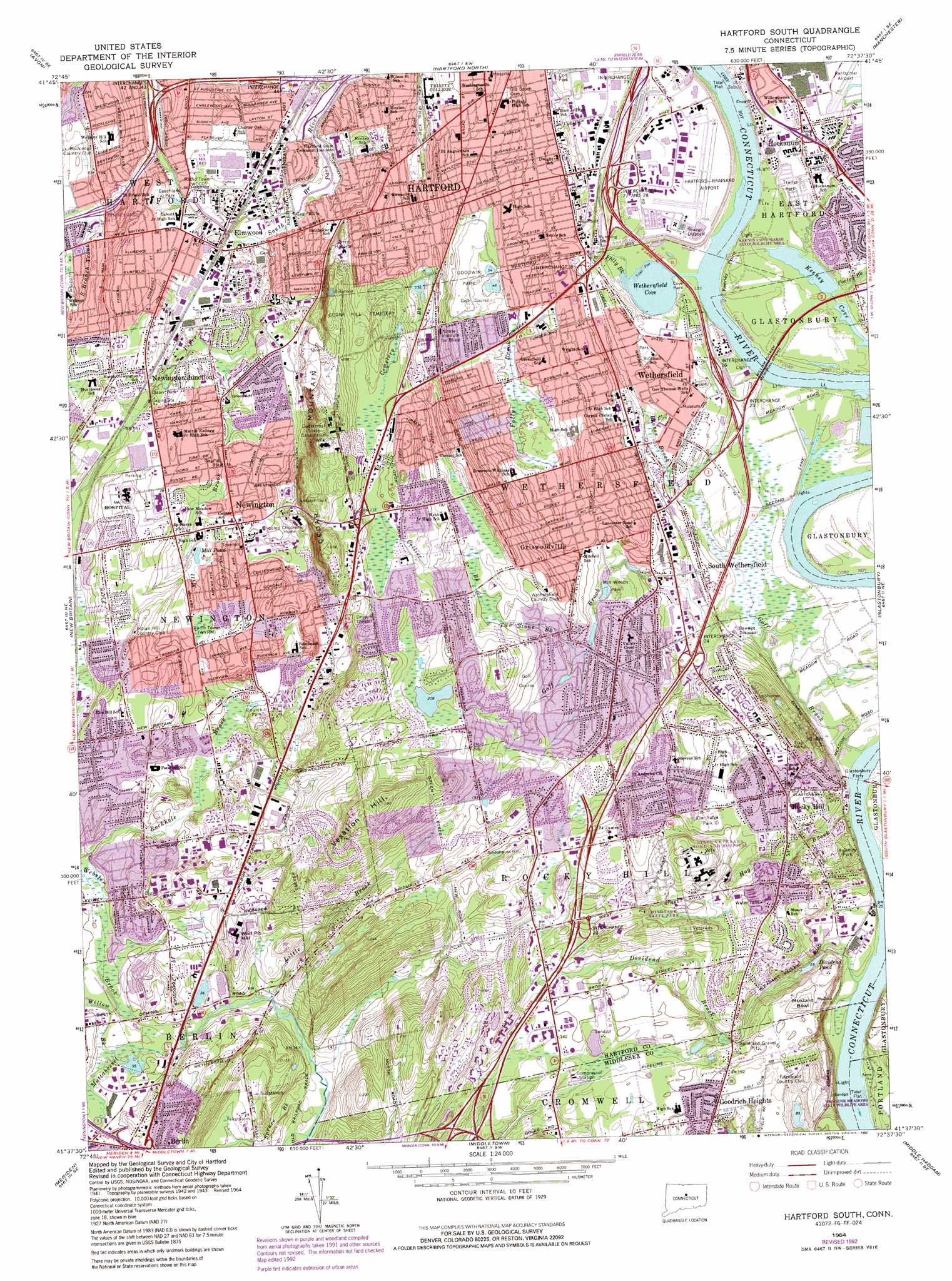
USGS Topo Quad 41072f6 - 1:24,000 scale
| Topo Map Name: | Hartford South |
| USGS Topo Quad ID: | 41072f6 |
| Print Size: | ca. 21 1/4" wide x 27" high |
| Southeast Coordinates: | 41.625° N latitude / 72.625° W longitude |
| Map Center Coordinates: | 41.6875° N latitude / 72.6875° W longitude |
| U.S. State: | CT |
| Filename: | o41072f6.jpg |
| Download Map JPG Image: | Hartford South topo map 1:24,000 scale |
| Map Type: | Topographic |
| Topo Series: | 7.5´ |
| Map Scale: | 1:24,000 |
| Source of Map Images: | United States Geological Survey (USGS) |
| Alternate Map Versions: |
Hartford South CT 1952, updated 1959 Download PDF Buy paper map Hartford South CT 1952, updated 1964 Download PDF Buy paper map Hartford South CT 1964, updated 1966 Download PDF Buy paper map Hartford South CT 1964, updated 1973 Download PDF Buy paper map Hartford South CT 1964, updated 1983 Download PDF Buy paper map Hartford South CT 1964, updated 1983 Download PDF Buy paper map Hartford South CT 1964, updated 1985 Download PDF Buy paper map Hartford South CT 1964, updated 1992 Download PDF Buy paper map Hartford South CT 2012 Download PDF Buy paper map Hartford South CT 2015 Download PDF Buy paper map |
1:24,000 Topo Quads surrounding Hartford South
New Hartford |
Tariffville |
Windsor Locks |
Broad Brook |
Ellington |
Collinsville |
Avon |
Hartford North |
Manchester |
Rockville |
Bristol |
New Britain |
Hartford South |
Glastonbury |
Marlborough |
Southington |
Meriden |
Middletown |
Middle Haddam |
Moodus |
Mount Carmel |
Wallingford |
Durham |
Haddam |
Deep River |
> Back to 41072e1 at 1:100,000 scale
> Back to 41072a1 at 1:250,000 scale
> Back to U.S. Topo Maps home
Hartford South topo map: Gazetteer
Hartford South: Airports
Corporate Ridge Heliport elevation 64m 209′Hartford-Brainard Airport elevation 9m 29′
HO Penn-1 Heliport elevation 43m 141′
Nayaug Seaplane Landing Area elevation 0m 0′
Veterans Home and Hospital Heliport elevation 46m 150′
Hartford South: Bars
Clay Banks Bar elevation 0m 0′Indian Reef elevation 21m 68′
Wethersfield Shoal elevation 0m 0′
Hartford South: Basins
Mustard Bowl elevation 39m 127′Hartford South: Bays
Keeney Cove elevation 0m 0′Wethersfield Cove elevation 0m 0′
Hartford South: Bridges
Folly Bridge elevation 16m 52′William Putnam Memorial Bridge elevation 0m 0′
Hartford South: Capes
Keeney Point elevation 10m 32′Hartford South: Channels
Clay Banks Bar Channel elevation 0m 0′Hartford South: Crossings
Interchange 23 elevation 59m 193′Interchange 24 elevation 14m 45′
Interchange 25 elevation 17m 55′
Interchange 26 elevation 26m 85′
Interchange 27 elevation 8m 26′
Interchange 28 elevation 11m 36′
Interchange 29 elevation 8m 26′
Interchange 41 elevation 51m 167′
Interchange 42 elevation 31m 101′
Interchange 43 elevation 31m 101′
Interchange 44 elevation 36m 118′
Hartford South: Dams
Dividend Pond Dam elevation 20m 65′Mill Pond Dam elevation 22m 72′
Hartford South: Islands
Wrights Island (historical) elevation 14m 45′Hartford South: Lakes
Dividend Pond elevation 20m 65′Mill Pond elevation 22m 72′
Hartford South: Mines
Balf Quarry elevation 42m 137′Hartford South: Parks
Badger Field elevation 31m 101′Beechland Park elevation 30m 98′
Bulkeley Park elevation 22m 72′
Burgoyne Park (historical) elevation 56m 183′
Candlewyck Park elevation 84m 275′
Center Green elevation 36m 118′
Churchill Park elevation 29m 95′
Colt Park South elevation 17m 55′
Columbus Park elevation 22m 72′
Cove Park elevation 7m 22′
Dinosaur State Park elevation 63m 206′
Elm Ridge Park elevation 41m 134′
Ferry Park elevation 4m 13′
Flanagan Field elevation 29m 95′
Folly Brook Natural Area elevation 17m 55′
Foster Heights Playground elevation 50m 164′
Francis Green elevation 37m 121′
Goodwin Park elevation 27m 88′
Hanmer Park elevation 28m 91′
Hockanum Park elevation 16m 52′
Hoyle Memorial Field elevation 46m 150′
Keeney Cove Marsh State Wildlife Area elevation 11m 36′
Mill Pond Park elevation 23m 75′
Mill Woods Park elevation 27m 88′
Newington Junction North Historic District elevation 28m 91′
Newington Junction South Historic District elevation 27m 88′
Newington Junction West Historic District elevation 32m 104′
Old Wethersfield Historic District elevation 14m 45′
Parkside Historic District elevation 24m 78′
Rock Ridge Park elevation 45m 147′
Shipyard Park elevation 17m 55′
South End Playground elevation 25m 82′
Starr Park elevation 29m 95′
Sterling Field elevation 27m 88′
Thomas J Hyland Memorial Park elevation 51m 167′
Twenty Rod Road Park elevation 70m 229′
Warner Memorial Park elevation 22m 72′
Wethersfield Green elevation 20m 65′
Hartford South: Populated Places
Colonial Mobile Home Park elevation 19m 62′Elm Hill elevation 48m 157′
Elmwood elevation 25m 82′
Goodrich Heights elevation 48m 157′
Griswoldville elevation 33m 108′
Hockanum elevation 20m 65′
Newington elevation 35m 114′
Newington Junction elevation 27m 88′
Rivermead Mobile Home Park elevation 16m 52′
Rocky Hill elevation 34m 111′
Saybrooke Village elevation 34m 111′
South Wethersfield elevation 18m 59′
Wethersfield elevation 25m 82′
Hartford South: Post Offices
Rocky Hill Post Office elevation 34m 111′Wethersfield Post Office elevation 24m 78′
Hartford South: Reservoirs
Bell Reservoir elevation 21m 68′Griswold Reservoir elevation 64m 209′
Mill Woods Pond elevation 26m 85′
Hartford South: Streams
Beaver Brook elevation 20m 65′Cemetery Brook elevation 52m 170′
Collier Brook elevation 51m 167′
Dividend Brook elevation 6m 19′
Folly Brook elevation 23m 75′
Folly Brook elevation 0m 0′
Goff Brook elevation 0m 0′
Hog Brook elevation 2m 6′
Little Brook elevation 11m 36′
Mill Brook elevation 21m 68′
Pewterpot Brook elevation 0m 0′
Piper Brook elevation 20m 65′
Porter Brook elevation 13m 42′
Rockhole Brook elevation 11m 36′
Schoolhouse Brook elevation 25m 82′
South Branch Trout Brook elevation 49m 160′
Spruce Brook elevation 8m 26′
Trout Brook elevation 20m 65′
Two Stone Brook elevation 29m 95′
Webster Brook elevation 13m 42′
Willow Brook elevation 9m 29′
Hartford South: Summits
Cedar Mountain elevation 84m 275′Elmwood Hill elevation 56m 183′
Hang-Dog Hill elevation 50m 164′
Harriss Hill elevation 44m 144′
Rocky Hill elevation 40m 131′
Rocky Hill elevation 48m 157′
Vexation Hill elevation 115m 377′
Wolcott Hill elevation 52m 170′
Wolf Pit Hill elevation 35m 114′
Hartford South: Swamps
Point Meadows elevation 13m 42′Hartford South: Woods
Wintergreen Woods elevation 74m 242′Hartford South digital topo map on disk
Buy this Hartford South topo map showing relief, roads, GPS coordinates and other geographical features, as a high-resolution digital map file on DVD:
New York, Vermont, Connecticut & Western Massachusetts
Buy digital topo maps: New York, Vermont, Connecticut & Western Massachusetts