Bristol Topo Map Connecticut
To zoom in, hover over the map of Bristol
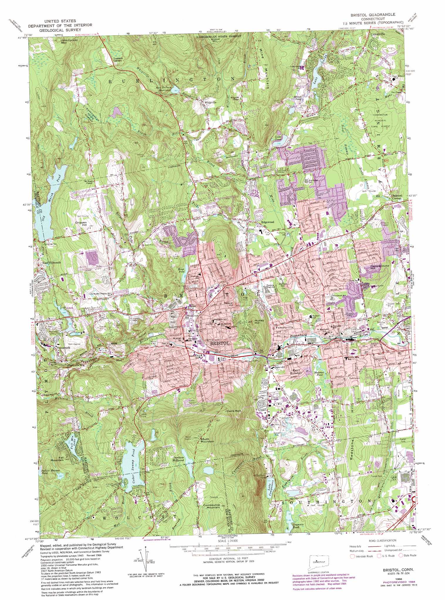
USGS Topo Quad 41072f8 - 1:24,000 scale
| Topo Map Name: | Bristol |
| USGS Topo Quad ID: | 41072f8 |
| Print Size: | ca. 21 1/4" wide x 27" high |
| Southeast Coordinates: | 41.625° N latitude / 72.875° W longitude |
| Map Center Coordinates: | 41.6875° N latitude / 72.9375° W longitude |
| U.S. State: | CT |
| Filename: | o41072f8.jpg |
| Download Map JPG Image: | Bristol topo map 1:24,000 scale |
| Map Type: | Topographic |
| Topo Series: | 7.5´ |
| Map Scale: | 1:24,000 |
| Source of Map Images: | United States Geological Survey (USGS) |
| Alternate Map Versions: |
Bristol CT 1953, updated 1956 Download PDF Buy paper map Bristol CT 1966, updated 1968 Download PDF Buy paper map Bristol CT 1966, updated 1973 Download PDF Buy paper map Bristol CT 1966, updated 1983 Download PDF Buy paper map Bristol CT 1966, updated 1985 Download PDF Buy paper map Bristol CT 2012 Download PDF Buy paper map Bristol CT 2015 Download PDF Buy paper map |
1:24,000 Topo Quads surrounding Bristol
Norfolk |
Winsted |
New Hartford |
Tariffville |
Windsor Locks |
West Torrington |
Torrington |
Collinsville |
Avon |
Hartford North |
Litchfield |
Thomaston |
Bristol |
New Britain |
Hartford South |
Woodbury |
Waterbury |
Southington |
Meriden |
Middletown |
Southbury |
Naugatuck |
Mount Carmel |
Wallingford |
Durham |
> Back to 41072e1 at 1:100,000 scale
> Back to 41072a1 at 1:250,000 scale
> Back to U.S. Topo Maps home
Bristol topo map: Gazetteer
Bristol: Airports
Green Acres Airport elevation 279m 915′Bristol: Bridges
Pierce Bridge elevation 73m 239′Bristol: Canals
New Haven and Northampton Canal elevation 56m 183′Bristol: Dams
Birge Pond Dam elevation 117m 383′Bristol Fish and Game Club Pond Dam elevation 76m 249′
Bristol Reservoir Dam elevation 183m 600′
Cedar Swamp Pond Dam elevation 272m 892′
Dunham Mill Pond Dam elevation 299m 980′
Dunham Mill Pond Dike elevation 281m 921′
Fall Mountain Lake Dam elevation 251m 823′
Lake Garda Dam elevation 74m 242′
Monce Pond Dam elevation 74m 242′
Old Marsh Pond Dam elevation 198m 649′
Whigville Reservoir Dam elevation 199m 652′
Bristol: Forests
Farmington Memorial Town Forest elevation 105m 344′Bristol: Lakes
Cedar Swamp Pond elevation 272m 892′Dunham Millpond elevation 281m 921′
Fall Mountain Lake elevation 251m 823′
Grannis Pond elevation 57m 187′
Lake Como elevation 85m 278′
Lake Garda elevation 74m 242′
Malones Pond elevation 64m 209′
Monce Pond elevation 74m 242′
Old Marsh Pond elevation 209m 685′
Bristol: Parks
Barnes Field elevation 74m 242′Bracket Park elevation 92m 301′
Carrington Park elevation 92m 301′
Casey Field elevation 78m 255′
East Plymouth Historic District elevation 189m 620′
Federal Hill Historic District elevation 148m 485′
Harts Corner Historic District elevation 85m 278′
Kern Park elevation 93m 305′
Lake Compounce Amusement Park elevation 66m 216′
Memorial Boulevard Park elevation 76m 249′
Muzzy Field Park elevation 103m 337′
Northwest Park elevation 83m 272′
Page Park elevation 117m 383′
Pine Lake Park elevation 66m 216′
Rockwell Park elevation 118m 387′
Seymour Park elevation 99m 324′
Western Little League Park elevation 59m 193′
Wilson Playground elevation 80m 262′
Bristol: Populated Places
Allentown elevation 251m 823′Bensted Corner elevation 84m 275′
Bristol elevation 93m 305′
East Bristol elevation 79m 259′
East Plymouth elevation 192m 629′
Edgewood elevation 76m 249′
Forestville elevation 79m 259′
Lamson Corner elevation 209m 685′
Pequabuck elevation 171m 561′
West District elevation 98m 321′
Whigville elevation 133m 436′
Bristol: Post Offices
Bristol Post Office elevation 118m 387′Pequabuck Post Office elevation 173m 567′
Bristol: Reservoirs
Birge Pond elevation 117m 383′Bristol Fish and Game Club Pond elevation 76m 249′
Bristol Reservoir Number 1 elevation 183m 600′
Compounce Lake elevation 61m 200′
Dunham Mill Pond elevation 281m 921′
Dunham Mill Pond elevation 299m 980′
Hidden Lake elevation 247m 810′
Lake Garda elevation 74m 242′
New Britain Reservoir elevation 173m 567′
Norton Park Pond elevation 53m 173′
Whigville Reservoir elevation 199m 652′
Bristol: Streams
Birge Pond Brook elevation 99m 324′Copper Mine Brook elevation 65m 213′
Cussgutter Brook elevation 61m 200′
Negro Hill Brook elevation 76m 249′
Polkville Ave Brook elevation 77m 252′
Whigville Brook elevation 105m 344′
Wildcat Brook elevation 105m 344′
Bristol: Summits
Campground Hill elevation 132m 433′Castle Rock elevation 251m 823′
Chippen Hill elevation 269m 882′
Compounce Mountain elevation 290m 951′
Fall Mountain elevation 284m 931′
Federal Hill elevation 164m 538′
Hurley Hill elevation 167m 547′
Mine Mountain elevation 199m 652′
Mount Hope elevation 297m 974′
Redstone Hill elevation 100m 328′
Round Hill elevation 139m 456′
South Mountain elevation 313m 1026′
West Hill elevation 139m 456′
Bristol: Swamps
Cedar Swamp (historical) elevation 272m 892′Scott Swamp elevation 90m 295′
Bristol: Trails
Spruce Hill Trail elevation 198m 649′Tunxis Trail elevation 253m 830′
Bristol: Tunnels
Terryville Tunnel elevation 229m 751′Bristol digital topo map on disk
Buy this Bristol topo map showing relief, roads, GPS coordinates and other geographical features, as a high-resolution digital map file on DVD:
New York, Vermont, Connecticut & Western Massachusetts
Buy digital topo maps: New York, Vermont, Connecticut & Western Massachusetts