Manchester Topo Map Connecticut
To zoom in, hover over the map of Manchester
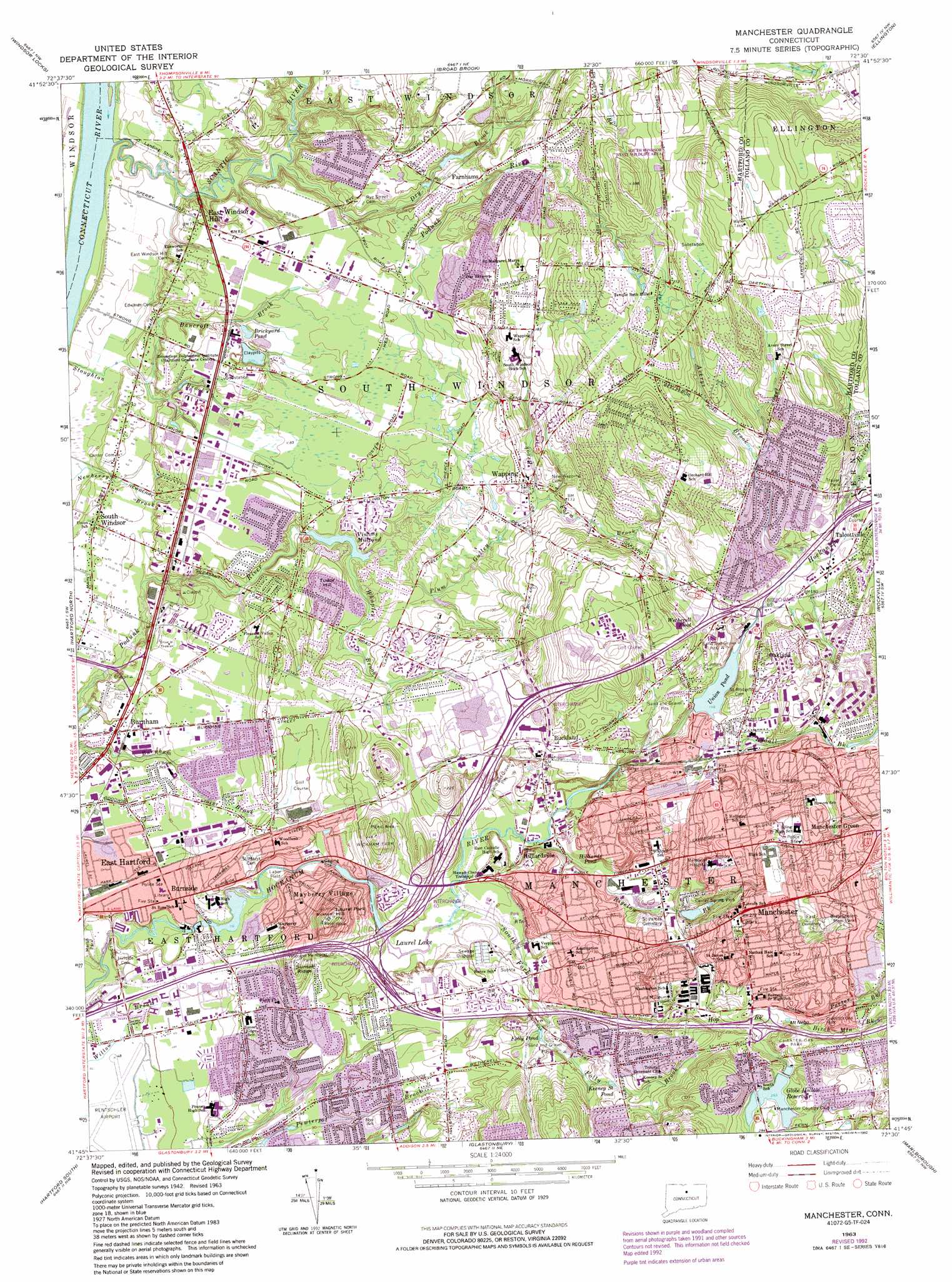
USGS Topo Quad 41072g5 - 1:24,000 scale
| Topo Map Name: | Manchester |
| USGS Topo Quad ID: | 41072g5 |
| Print Size: | ca. 21 1/4" wide x 27" high |
| Southeast Coordinates: | 41.75° N latitude / 72.5° W longitude |
| Map Center Coordinates: | 41.8125° N latitude / 72.5625° W longitude |
| U.S. State: | CT |
| Filename: | o41072g5.jpg |
| Download Map JPG Image: | Manchester topo map 1:24,000 scale |
| Map Type: | Topographic |
| Topo Series: | 7.5´ |
| Map Scale: | 1:24,000 |
| Source of Map Images: | United States Geological Survey (USGS) |
| Alternate Map Versions: |
Manchester CT 1928 Download PDF Buy paper map Manchester CT 1952, updated 1959 Download PDF Buy paper map Manchester CT 1963, updated 1965 Download PDF Buy paper map Manchester CT 1963, updated 1970 Download PDF Buy paper map Manchester CT 1963, updated 1984 Download PDF Buy paper map Manchester CT 1963, updated 1988 Download PDF Buy paper map Manchester CT 1963, updated 1992 Download PDF Buy paper map Manchester CT 2012 Download PDF Buy paper map Manchester CT 2015 Download PDF Buy paper map |
1:24,000 Topo Quads surrounding Manchester
Southwick |
West Springfield |
Springfield South |
Hampden |
Monson |
Tariffville |
Windsor Locks |
Broad Brook |
Ellington |
Stafford Springs |
Avon |
Hartford North |
Manchester |
Rockville |
South Coventry |
New Britain |
Hartford South |
Glastonbury |
Marlborough |
Columbia |
Meriden |
Middletown |
Middle Haddam |
Moodus |
Colchester |
> Back to 41072e1 at 1:100,000 scale
> Back to 41072a1 at 1:250,000 scale
> Back to U.S. Topo Maps home
Manchester topo map: Gazetteer
Manchester: Airports
Bancroft Airport elevation 8m 26′Ralphs Seaplane Base elevation 2m 6′
Rentschler Airport elevation 9m 29′
Manchester: Crossings
Interchange 59 elevation 43m 141′Interchange 60 elevation 28m 91′
Interchange 62 elevation 51m 167′
Interchange 63 elevation 62m 203′
Manchester: Dams
Cast and Blast Pond Dam elevation 36m 118′Globe Hollow Reservoir Dam elevation 84m 275′
Laurel Lake Dam elevation 27m 88′
Lydall Pond Number 1 Dam elevation 80m 262′
Podunk Pond Dam elevation 17m 55′
Scotland Road Dam elevation 16m 52′
Union Pond Dam elevation 45m 147′
Manchester: Lakes
Brickyard Pond elevation 15m 49′Folly Pond elevation 42m 137′
Goulds Pond elevation 65m 213′
Hilliards Pond elevation 32m 104′
Keeney Street Pond elevation 55m 180′
Laurel Lake elevation 20m 65′
Vintons Millpond elevation 19m 62′
Wetherell Pond elevation 55m 180′
Manchester: Parks
Buckland Green elevation 36m 118′Center Park elevation 78m 255′
Center Spring Park elevation 56m 183′
Center Spring Pond Park elevation 49m 160′
Charter Oak Park elevation 80m 262′
Cheney Brothers Historic District elevation 62m 203′
Dwyer Park elevation 17m 55′
Globe Hollow Field elevation 74m 242′
Labor Field elevation 19m 62′
Leber Field elevation 25m 82′
Martin Park elevation 7m 22′
Nature Park elevation 29m 95′
Nevers Road Park elevation 57m 187′
Nicholas Forum Park elevation 11m 36′
Robertson Park elevation 49m 160′
Rye Street Park elevation 24m 78′
South Windsor State Wildlife Area elevation 102m 334′
Veterans Memorial Park elevation 45m 147′
Veterans Memorial Park elevation 16m 52′
Wickham Park elevation 53m 173′
Manchester: Populated Places
Buckland elevation 49m 160′Burnham elevation 17m 55′
Burnside elevation 24m 78′
Coachlight Village elevation 6m 19′
East Hartford elevation 16m 52′
East Windsor Hill elevation 16m 52′
Farnhams elevation 43m 141′
Flax Hill Elderly Housing elevation 59m 193′
Hilliardville elevation 33m 108′
Manchester elevation 83m 272′
Manchester Green elevation 98m 321′
Mayberry Village elevation 58m 190′
Oakland elevation 63m 206′
Oxford Village elevation 39m 127′
South Windsor elevation 26m 85′
South Windsor elevation 10m 32′
Talcottville elevation 65m 213′
Tudor Village elevation 13m 42′
Wapping elevation 35m 114′
Wapping Mews Elderly Housing elevation 101m 331′
Manchester: Reservoirs
Cast and Blast Pond elevation 36m 118′Globe Hollow Reservoir elevation 84m 275′
Hockanum River Reservoir elevation 16m 52′
Lydall Pond Number 1 elevation 80m 262′
Podunk Pond elevation 17m 55′
Salter Pond elevation 80m 262′
Union Pond elevation 45m 147′
Wickham Reservoir elevation 81m 265′
Manchester: Ridges
Sunset Ridge elevation 62m 203′Manchester: Streams
Averys Brook elevation 54m 177′Bancroft Brook elevation 9m 29′
Bigelow Brook elevation 28m 91′
Birch Mountain Brook elevation 73m 239′
Dry Brook elevation 8m 26′
Farm Brook elevation 29m 95′
Folly Brook elevation 33m 108′
Hop Brook elevation 33m 108′
Lydall Brook elevation 44m 144′
Plum Gulley Brook elevation 17m 55′
Porter Brook elevation 73m 239′
Scantic River elevation 7m 22′
South Fork Hockanum River elevation 22m 72′
Stoughton Brook elevation 4m 13′
Tankerhoosen River elevation 55m 180′
Whaples Brook elevation 14m 45′
Manchester: Summits
Academy Hill elevation 81m 265′Laurel Park Hill elevation 82m 269′
Mount Nebo elevation 76m 249′
Toby Hill elevation 40m 131′
Tudor Hill elevation 40m 131′
Wickham Hill elevation 32m 104′
Manchester: Trails
East Hartford Cross Country Ski and Jogging Trails elevation 32m 104′Manchester digital topo map on disk
Buy this Manchester topo map showing relief, roads, GPS coordinates and other geographical features, as a high-resolution digital map file on DVD:
New York, Vermont, Connecticut & Western Massachusetts
Buy digital topo maps: New York, Vermont, Connecticut & Western Massachusetts