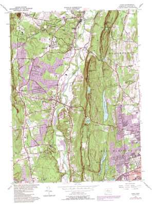
Avon Topo Map Connecticut
To zoom in, hover over the map of Avon
USGS Topo Quad 41072g7 - 1:24,000 scale
| Topo Map Name: | Avon |
| USGS Topo Quad ID: | 41072g7 |
| Print Size: | ca. 21 1/4" wide x 27" high |
| Southeast Coordinates: | 41.75° N latitude / 72.75° W longitude |
| Map Center Coordinates: | 41.8125° N latitude / 72.8125° W longitude |
| U.S. State: | CT |
| Filename: | o41072g7.jpg |
| Download Map JPG Image: | Avon topo map 1:24,000 scale |
| Map Type: | Topographic |
| Topo Series: | 7.5´ |
| Map Scale: | 1:24,000 |
| Source of Map Images: | United States Geological Survey (USGS) |
| Alternate Map Versions: |
Avon CT 1957, updated 1958 Download PDF Buy paper map Avon CT 1957, updated 1966 Download PDF Buy paper map Avon CT 1957, updated 1970 Download PDF Buy paper map Avon CT 1957, updated 1984 Download PDF Buy paper map Avon CT 1957, updated 1988 Download PDF Buy paper map Avon CT 1957, updated 1988 Download PDF Buy paper map Avon CT 2012 Download PDF Buy paper map Avon CT 2015 Download PDF Buy paper map |
1:24,000 Topo Quads surrounding Avon
> Back to 41072e1 at 1:100,000 scale
> Back to 41072a1 at 1:250,000 scale
> Back to U.S. Topo Maps home
Avon topo map: Gazetteer
Avon: Dams
Bugbee Reservoir Dam elevation 52m 170′Cold Springs Dam elevation 61m 200′
Ensign Bickford Dam elevation 69m 226′
Gale Pond Dam elevation 127m 416′
Hartford Reservoir 6 East Dam elevation 113m 370′
Hartford Reservoir 6 South Dam elevation 124m 406′
Hartford Reservoir 6 Southeast Dam elevation 123m 403′
Hartford Reservoir Number 1 Dam elevation 78m 255′
Hartford Reservoir Number 2 Dam elevation 122m 400′
Hartford Reservoir Number 3 Dam elevation 121m 396′
Hartford Reservoir Number 5 Dam elevation 101m 331′
Stub Pond Dam elevation 80m 262′
Talcott Dam elevation 138m 452′
Talcott Reservoir Diversion Dike elevation 137m 449′
Talcott Reservoir Main Dam elevation 138m 452′
Avon: Forests
Massacoe State Forest elevation 112m 367′Newton Brainard Forest elevation 190m 623′
Avon: Lakes
Beaverdam Pond elevation 72m 236′Dyke Pond elevation 119m 390′
Ely Pond elevation 199m 652′
Gale Pond elevation 127m 416′
Hazel Meadow Pond elevation 83m 272′
Hoe Pond elevation 231m 757′
Lake Erie elevation 65m 213′
Lake Louise elevation 172m 564′
Lily Pond elevation 84m 275′
Town Pool elevation 79m 259′
Walton Pond elevation 67m 219′
Welles Pond elevation 140m 459′
Avon: Parks
Continental Army Hospital State Monument elevation 124m 406′Eisenhower Park elevation 52m 170′
Fernridge Park elevation 52m 170′
Fisher Meadows Recreation Area elevation 47m 154′
MacDonald Memorial Park elevation 162m 531′
Nod Brook State Wildlife Area elevation 44m 144′
Penwood State Park elevation 204m 669′
Pine Grove Historic District elevation 85m 278′
Pine Grove School Historic District elevation 86m 282′
Scoville Park and Ballfield elevation 79m 259′
Simsbury State Wildlife Area elevation 45m 147′
Sperry Park elevation 62m 203′
Stratton Brook State Park elevation 78m 255′
Sycamore Hills Recreation Area elevation 87m 285′
Talcott Mountain State Park elevation 274m 898′
Weatogue Park elevation 54m 177′
Avon: Pillars
The Pinnacle elevation 217m 711′Avon: Populated Places
Alsop Corner elevation 53m 173′Avon elevation 65m 213′
Avon Park North elevation 68m 223′
Avon Park South elevation 90m 295′
Barber Corner (historical) elevation 44m 144′
Case Corner elevation 64m 209′
Crowleys Corner elevation 87m 285′
Foote Corners elevation 52m 170′
Old Avon Village elevation 59m 193′
Pine Hill elevation 77m 252′
Tootin' Hills elevation 112m 367′
Weatogue elevation 90m 295′
West Avon elevation 94m 308′
West Simsbury elevation 95m 311′
Westmoor Park elevation 57m 187′
Whitings Corner elevation 58m 190′
Avon: Post Offices
West Simsbury Post Office elevation 99m 324′Avon: Ranges
Metacomet Ridge elevation 251m 823′Avon: Reservoirs
Bugbee Reservoir elevation 52m 170′Cold Spring Reservoir elevation 61m 200′
Ensign Bickford Pond elevation 69m 226′
Hartford Reservoir Number 1 elevation 78m 255′
Hartford Reservoir Number 2 elevation 122m 400′
Hartford Reservoir Number 3 elevation 121m 396′
Hartford Reservoir Number 5 elevation 101m 331′
Hartford Reservoir Number 6 elevation 124m 406′
Stub Pond elevation 80m 262′
Talcott Reservoir elevation 138m 452′
Talcott Reservoir elevation 137m 449′
Avon: Streams
Big Brook elevation 81m 265′Chidsey Brook elevation 81m 265′
Grimes Brook elevation 67m 219′
Hop Brook elevation 55m 180′
King Phillip Brook elevation 46m 150′
Lucy Brook elevation 54m 177′
Minister Brook elevation 53m 173′
Nod Brook elevation 49m 160′
Powder Mill Brook elevation 52m 170′
Russell Brook elevation 51m 167′
Second Brook elevation 52m 170′
Still Brook elevation 56m 183′
Stratton Brook elevation 71m 232′
Thompson Brook elevation 48m 157′
Trout Brook elevation 47m 154′
Wiggin Brook elevation 78m 255′
Avon: Summits
Avon Mountain elevation 191m 626′Bushy Hill elevation 133m 436′
Ely Mound elevation 246m 807′
Grant Hill elevation 88m 288′
Killkenny Rocks elevation 194m 636′
King Phillip Mountain elevation 264m 866′
Little Phillip Mountain elevation 187m 613′
Pond Ledge Hill elevation 151m 495′
Talcott Mountain elevation 276m 905′
The Sugarloaf elevation 174m 570′
Thompson Hill elevation 122m 400′
Avon: Swamps
Hart Meadow elevation 202m 662′Spice Bush Swamp elevation 53m 173′
Avon: Trails
Metacomet Trail elevation 220m 721′Avon: Valleys
Horseshoe Cove elevation 67m 219′Avon: Woods
Mooneys Woods elevation 49m 160′Avon digital topo map on disk
Buy this Avon topo map showing relief, roads, GPS coordinates and other geographical features, as a high-resolution digital map file on DVD:
New York, Vermont, Connecticut & Western Massachusetts
Buy digital topo maps: New York, Vermont, Connecticut & Western Massachusetts


