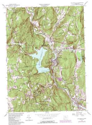
Collinsville Topo Map Connecticut
To zoom in, hover over the map of Collinsville
USGS Topo Quad 41072g8 - 1:24,000 scale
| Topo Map Name: | Collinsville |
| USGS Topo Quad ID: | 41072g8 |
| Print Size: | ca. 21 1/4" wide x 27" high |
| Southeast Coordinates: | 41.75° N latitude / 72.875° W longitude |
| Map Center Coordinates: | 41.8125° N latitude / 72.9375° W longitude |
| U.S. State: | CT |
| Filename: | o41072g8.jpg |
| Download Map JPG Image: | Collinsville topo map 1:24,000 scale |
| Map Type: | Topographic |
| Topo Series: | 7.5´ |
| Map Scale: | 1:24,000 |
| Source of Map Images: | United States Geological Survey (USGS) |
| Alternate Map Versions: |
Collinsville CT 1956, updated 1958 Download PDF Buy paper map Collinsville CT 1956, updated 1966 Download PDF Buy paper map Collinsville CT 1956, updated 1970 Download PDF Buy paper map Collinsville CT 1956, updated 1984 Download PDF Buy paper map Collinsville CT 1956, updated 1988 Download PDF Buy paper map Collinsville CT 2012 Download PDF Buy paper map Collinsville CT 2015 Download PDF Buy paper map |
1:24,000 Topo Quads surrounding Collinsville
> Back to 41072e1 at 1:100,000 scale
> Back to 41072a1 at 1:250,000 scale
> Back to U.S. Topo Maps home
Collinsville topo map: Gazetteer
Collinsville: Benches
Slashers Ledges elevation 259m 849′Collinsville: Bridges
Kingdom Bridge elevation 121m 396′Mill Pond Bridge elevation 166m 544′
Perry Bridge elevation 79m 259′
Collinsville: Capes
Zwick Point elevation 154m 505′Collinsville: Dams
Collins Company Lower Dam elevation 110m 360′Collins Company Upper Dam elevation 91m 298′
Henrys Pond Dam Number 2 elevation 78m 255′
Nepaug Dam elevation 150m 492′
Phelps Dam elevation 145m 475′
Unionville Reservoir Upper Dam elevation 132m 433′
Collinsville: Forests
Nassahegan State Forest elevation 229m 751′Nepaug State Forest elevation 188m 616′
Collinsville: Lakes
Bond Pond elevation 98m 321′Secret Lake elevation 86m 282′
Collinsville: Parks
Browns Corner Recreation Area elevation 162m 531′Countryside Park elevation 133m 436′
Found Lake Park elevation 214m 702′
Mill Pond Park elevation 109m 357′
Collinsville: Populated Places
Bahre Corner elevation 180m 590′Browns Corner elevation 173m 567′
Burlington elevation 258m 846′
Canton elevation 108m 354′
Canton Center elevation 125m 410′
Canton Valley elevation 211m 692′
Cherry Park elevation 104m 341′
Collinsville elevation 99m 324′
Huckleberry Hills Trails elevation 180m 590′
Lovely Street elevation 95m 311′
Nepaug elevation 168m 551′
Puddle Town elevation 108m 354′
Silvermine Acres elevation 124m 406′
Town Hill elevation 302m 990′
Unionville elevation 77m 252′
Collinsville: Post Offices
Canton Center Post Office elevation 124m 406′Pine Meadow Post Office elevation 122m 400′
Collinsville: Reservoirs
Collinsville Reservoir elevation 149m 488′Farmington River Reservoir elevation 110m 360′
Henrys Pond Number 2 elevation 78m 255′
Nepaug Reservoir elevation 150m 492′
Nepaug Reservoir elevation 150m 492′
New Hartford Reservoir elevation 218m 715′
Unionville Reservoir elevation 126m 413′
Unionville Upper Reservoir elevation 132m 433′
Collinsville: Ridges
Two Buck Ring elevation 245m 803′Collinsville: Springs
Massacoe Spring elevation 114m 374′Collinsville: Streams
Barbour Brook elevation 126m 413′Beckwith Brook elevation 162m 531′
Bradley Brook elevation 122m 400′
Bunnell Brook elevation 77m 252′
Cherry Brook elevation 96m 314′
Clear Brook elevation 147m 482′
East Branch Farmington River elevation 110m 360′
Hawley Brook elevation 82m 269′
Jim Brook elevation 86m 282′
Marandus Brook elevation 166m 544′
Nepaug River elevation 101m 331′
North Branch Bunnell Brook elevation 244m 800′
Phelps Brook elevation 148m 485′
Punch Brook elevation 90m 295′
Ratlum Brook elevation 110m 360′
Roaring Brook elevation 60m 196′
South Branch Bunnell Brook elevation 244m 800′
Spruce Brook elevation 162m 531′
Unionville Brook elevation 75m 246′
West Branch Farmington River elevation 110m 360′
Collinsville: Summits
Barnes Hill elevation 283m 928′Bee Mountain elevation 285m 935′
Breezy Hill elevation 327m 1072′
East Hill elevation 261m 856′
Garrett Mountain elevation 275m 902′
Huckleberry Hill elevation 132m 433′
Huckleberry Hill elevation 223m 731′
Johnnycake Mountain elevation 354m 1161′
Jones Mountain elevation 294m 964′
Mount Horr elevation 238m 780′
Onion Mountain elevation 253m 830′
Rattlesnake Hill elevation 257m 843′
Schoolhouse Hill elevation 288m 944′
Scranton Mountain elevation 300m 984′
Sweetheart Mountain elevation 246m 807′
Taine Mountain elevation 268m 879′
Wildcat Mountain elevation 262m 859′
Woodford Hill elevation 189m 620′
Collinsville: Swamps
Atwood Swamp elevation 212m 695′Smith Meadow elevation 237m 777′
Collinsville: Trails
Tunxis Trail elevation 235m 770′Collinsville digital topo map on disk
Buy this Collinsville topo map showing relief, roads, GPS coordinates and other geographical features, as a high-resolution digital map file on DVD:
New York, Vermont, Connecticut & Western Massachusetts
Buy digital topo maps: New York, Vermont, Connecticut & Western Massachusetts


