Sherwood Point Topo Map Connecticut
To zoom in, hover over the map of Sherwood Point
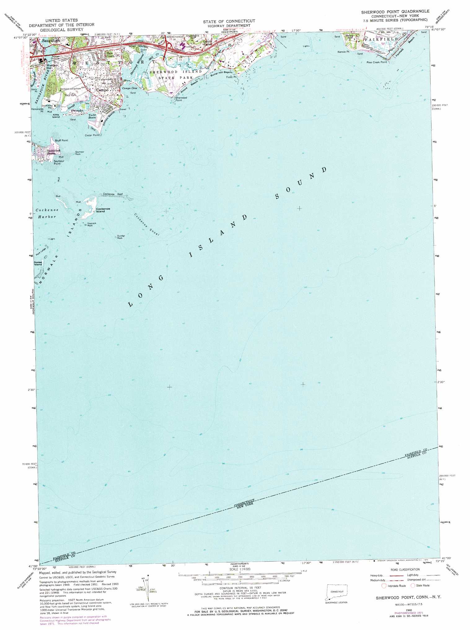
USGS Topo Quad 41073a3 - 1:24,000 scale
| Topo Map Name: | Sherwood Point |
| USGS Topo Quad ID: | 41073a3 |
| Print Size: | ca. 21 1/4" wide x 27" high |
| Southeast Coordinates: | 41° N latitude / 73.25° W longitude |
| Map Center Coordinates: | 41.0625° N latitude / 73.3125° W longitude |
| U.S. States: | CT, NY |
| Filename: | o41073a3.jpg |
| Download Map JPG Image: | Sherwood Point topo map 1:24,000 scale |
| Map Type: | Topographic |
| Topo Series: | 7.5´ |
| Map Scale: | 1:24,000 |
| Source of Map Images: | United States Geological Survey (USGS) |
| Alternate Map Versions: |
Sherwood Point CT 1951, updated 1959 Download PDF Buy paper map Sherwood Point CT 1951, updated 1960 Download PDF Buy paper map Sherwood Point CT 1960, updated 1962 Download PDF Buy paper map Sherwood Point CT 1960, updated 1973 Download PDF Buy paper map Sherwood Point CT 2012 Download PDF Buy paper map Sherwood Point CT 2015 Download PDF Buy paper map |
1:24,000 Topo Quads surrounding Sherwood Point
Peach Lake |
Bethel |
Botsford |
Long Hill |
Ansonia |
Pound Ridge |
Norwalk North |
Westport |
Bridgeport |
Milford |
Stamford |
Norwalk South |
Sherwood Point |
||
Bayville |
Lloyd Harbor |
Northport |
Saint James |
Port Jefferson |
Hicksville |
Huntington |
Greenlawn |
Central Islip |
Patchogue |
> Back to 41073a1 at 1:100,000 scale
> Back to 41072a1 at 1:250,000 scale
> Back to U.S. Topo Maps home
Sherwood Point topo map: Gazetteer
Sherwood Point: Bars
Cockenoe Reef elevation 0m 0′Cockenoe Shoal elevation 0m 0′
Georges Rock elevation 0m 0′
Peck Ledge elevation 0m 0′
Sherwood Point: Bays
Burritt Cove elevation 0m 0′Cockenoe Bay elevation 0m 0′
Cockenoe Harbor elevation 0m 0′
Compo Cove elevation 0m 0′
Sherwood Point: Beaches
Alvord Beach elevation 0m 0′Burial Hill Beach elevation 0m 0′
Compo Beach elevation 3m 9′
Fairfield Beach elevation 0m 0′
Fairfield Public Beach elevation 1m 3′
South Pine Creek Beach elevation 0m 0′
Sherwood Point: Capes
Bluff Point elevation 0m 0′Cedar Point elevation 0m 0′
Compo Point elevation 2m 6′
Frost Point elevation 2m 6′
Grove Point elevation 0m 0′
Hendricks Point elevation 2m 6′
Kensie Point elevation 4m 13′
Pine Creek Point elevation 0m 0′
Seymour Point elevation 0m 0′
Sherwood Point elevation 0m 0′
Stony Point elevation 0m 0′
Sherwood Point: Crossings
Interchange 18 elevation 10m 32′Interchange Eighteen elevation 7m 22′
Sherwood Point: Guts
Grays Creek elevation 0m 0′Mill Creek elevation 0m 0′
Sherwood Point: Islands
Cockenoe Island elevation 0m 0′Dunder Rock elevation 0m 0′
Goose Island elevation 1m 3′
Hall Island elevation 1m 3′
Haycock Rock elevation 0m 0′
Kitts Island elevation 0m 0′
Sherwood Island elevation 5m 16′
Sherwood Point: Lakes
Sherwood Millpond elevation 0m 0′Sherwood Point: Parks
Compo-Owenoke Historic District elevation 4m 13′Sherwood Island State Park elevation 3m 9′
Westport Longshore Club Park elevation 6m 19′
Sherwood Point: Pillars
Channel Rock elevation 0m 0′Hanford Rock elevation 0m 0′
Sherwood Point: Populated Places
Compo elevation 1m 3′Greens Farms elevation 16m 52′
Hale Court elevation 9m 29′
Owenoke elevation 1m 3′
Saugatuck elevation 0m 0′
Saugatuck Shores elevation 1m 3′
Sherwood Point: Streams
Greens Farms Brook elevation 1m 3′Indian River elevation -2m -7′
Muddy Brook elevation 3m 9′
Pine Creek elevation 0m 0′
Sasco Brook elevation 1m 3′
Saugatuck River elevation 0m 0′
Sherwood Point: Summits
Compo Hill elevation 34m 111′Seymour Rock elevation 0m 0′
Sherwood Point digital topo map on disk
Buy this Sherwood Point topo map showing relief, roads, GPS coordinates and other geographical features, as a high-resolution digital map file on DVD:
New York, Vermont, Connecticut & Western Massachusetts
Buy digital topo maps: New York, Vermont, Connecticut & Western Massachusetts