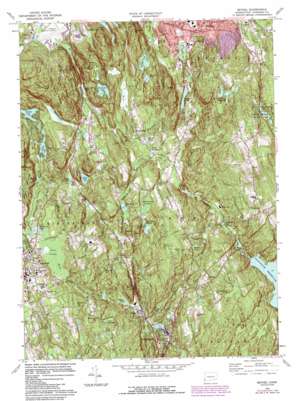
Bethel Topo Map Connecticut
To zoom in, hover over the map of Bethel
USGS Topo Quad 41073c4 - 1:24,000 scale
| Topo Map Name: | Bethel |
| USGS Topo Quad ID: | 41073c4 |
| Print Size: | ca. 21 1/4" wide x 27" high |
| Southeast Coordinates: | 41.25° N latitude / 73.375° W longitude |
| Map Center Coordinates: | 41.3125° N latitude / 73.4375° W longitude |
| U.S. State: | CT |
| Filename: | o41073c4.jpg |
| Download Map JPG Image: | Bethel topo map 1:24,000 scale |
| Map Type: | Topographic |
| Topo Series: | 7.5´ |
| Map Scale: | 1:24,000 |
| Source of Map Images: | United States Geological Survey (USGS) |
| Alternate Map Versions: |
Bethel CT 1951, updated 1959 Download PDF Buy paper map Bethel CT 1959, updated 1961 Download PDF Buy paper map Bethel CT 1959, updated 1966 Download PDF Buy paper map Bethel CT 1970, updated 1973 Download PDF Buy paper map Bethel CT 1970, updated 1984 Download PDF Buy paper map Bethel CT 1970, updated 1988 Download PDF Buy paper map Bethel CT 2012 Download PDF Buy paper map Bethel CT 2015 Download PDF Buy paper map |
1:24,000 Topo Quads surrounding Bethel
> Back to 41073a1 at 1:100,000 scale
> Back to 41072a1 at 1:250,000 scale
> Back to U.S. Topo Maps home
Bethel topo map: Gazetteer
Bethel: Airports
Danbury Municipal Airport elevation 138m 452′Bethel: Areas
Devils Den elevation 158m 518′Bethel: Dams
Bethels Pond Dam elevation 196m 643′Bushy Hill Pond Dam elevation 216m 708′
Chestnut Ridge Reservoir Dam elevation 202m 662′
Eureka Lake Dam elevation 168m 551′
Factory Pond Dam elevation 100m 328′
Hattertown Pond Dam elevation 212m 695′
Mountain Pond Dam elevation 181m 593′
Parks Pond Dam elevation 165m 541′
Putnam Park Pond Dam elevation 180m 590′
Steichens Pond Dam elevation 145m 475′
Wataba Lake Dam elevation 170m 557′
Waubeeka Lake Dam elevation 216m 708′
Bethel: Lakes
Bennett Ponds elevation 160m 524′Candees Pond elevation 108m 354′
Factory Pond elevation 100m 328′
Fox Hill Lake elevation 168m 551′
Hawley Pond elevation 129m 423′
Hazen Pond elevation 181m 593′
Johns Pond elevation 141m 462′
Lees Pond elevation 161m 528′
Little Pond elevation 151m 495′
Millers Pond elevation 119m 390′
Moffitts Pond elevation 178m 583′
Noroneke Lake elevation 165m 541′
Outpost Inn Pond elevation 175m 574′
Parks Pond elevation 165m 541′
Pecks Pond elevation 132m 433′
Perrys Pond elevation 132m 433′
Putnam Park Pond elevation 180m 590′
Steichens Ponds elevation 145m 475′
Sugar Hollow Pond elevation 150m 492′
Sympaug Pond elevation 113m 370′
Tarrywile Lake elevation 150m 492′
Taylors Pond elevation 170m 557′
Umpawaug Pond elevation 137m 449′
Waubeeka Lake elevation 216m 708′
Bethel: Parks
Aldrich Park elevation 173m 567′Ciuccoli Field elevation 227m 744′
Copps Hill Common elevation 201m 659′
East Ridge Recreation Area elevation 227m 744′
Martin Park elevation 153m 501′
Overlook Park elevation 151m 495′
P T Barnum Square elevation 114m 374′
Parloa Field elevation 111m 364′
Putnam Memorial State Park elevation 183m 600′
Ridgefield Center Historic District elevation 222m 728′
Seth Low Pierrepont State Park Reserve elevation 292m 958′
Veterans Park elevation 218m 715′
Weir Farm National Historic Site elevation 188m 616′
Wooster Mountain State Park elevation 162m 531′
Bethel: Populated Places
Bethel elevation 115m 377′Boston elevation 175m 574′
Branchville elevation 104m 341′
Casagmo elevation 197m 646′
Fox Hill elevation 193m 633′
Georgetown elevation 108m 354′
Lonetown elevation 193m 633′
Miry Brook elevation 145m 475′
Redding elevation 181m 593′
Ridgefield elevation 223m 731′
Selleck Four Corners (historical) elevation 93m 305′
Topstone elevation 137m 449′
Wataba Lake elevation 176m 577′
West Redding elevation 127m 416′
Bethel: Post Offices
Georgetown Post Office elevation 106m 347′Redding Town Post Office elevation 200m 656′
Bethel: Reservoirs
Bethels Pond elevation 196m 643′Bushy Hill Pond elevation 216m 708′
Chestnut Ridge Reservoir elevation 202m 662′
Eureka Lake elevation 168m 551′
Great Pond elevation 155m 508′
Hattertown Pond elevation 212m 695′
Mountain Pond elevation 181m 593′
Todd Park elevation 133m 436′
Wataba Lake elevation 170m 557′
Bethel: Streams
Blackmans Pond Brook elevation 113m 370′Bogus Mountain Brook elevation 115m 377′
Branchville Brook elevation 106m 347′
Cemetery Brook elevation 126m 413′
Cooper Pond Brook elevation 104m 341′
Gilbert Bennett Brook elevation 94m 308′
Moffitts Brook elevation 96m 314′
Nob Crook Brook elevation 87m 285′
Ridgefield Brook elevation 149m 488′
Umpawaug Pond Brook elevation 129m 423′
West Redding Brook elevation 124m 406′
Bethel: Summits
Barrow Mountain elevation 255m 836′Biddle Hill elevation 223m 731′
Bogus Mountain elevation 254m 833′
Branchville Hill elevation 225m 738′
Cains Hill elevation 213m 698′
Cedar Mountain elevation 191m 626′
Diamond Hill elevation 186m 610′
Fire Hill elevation 210m 688′
Florida Hill elevation 189m 620′
Gilbert Hill elevation 186m 610′
Goodsell Hill elevation 211m 692′
Huckleberry Hill elevation 204m 669′
Ivy Hill elevation 234m 767′
Middle Mountain elevation 240m 787′
Moses Mountain elevation 296m 971′
Nod Hill elevation 199m 652′
Nod HIll elevation 197m 646′
Picketts Ridge elevation 220m 721′
Pine Mountain elevation 304m 997′
Prospect Hill elevation 228m 748′
Prospect Hill elevation 196m 643′
Spruce Mountain elevation 272m 892′
Sunset Hill elevation 95m 311′
Thomas Mountain elevation 286m 938′
Topstone Mountain elevation 203m 666′
Town Mountain elevation 264m 866′
Umpawaug Hill elevation 195m 639′
Windy Hill elevation 220m 721′
Wooster Mountain elevation 275m 902′
Bethel: Swamps
Great Swamp elevation 174m 570′Huckleberry Swamp elevation 141m 462′
Umpog Swamp elevation 112m 367′
Bethel: Valleys
Redding Glen elevation 91m 298′Bethel digital topo map on disk
Buy this Bethel topo map showing relief, roads, GPS coordinates and other geographical features, as a high-resolution digital map file on DVD:
New York, Vermont, Connecticut & Western Massachusetts
Buy digital topo maps: New York, Vermont, Connecticut & Western Massachusetts


