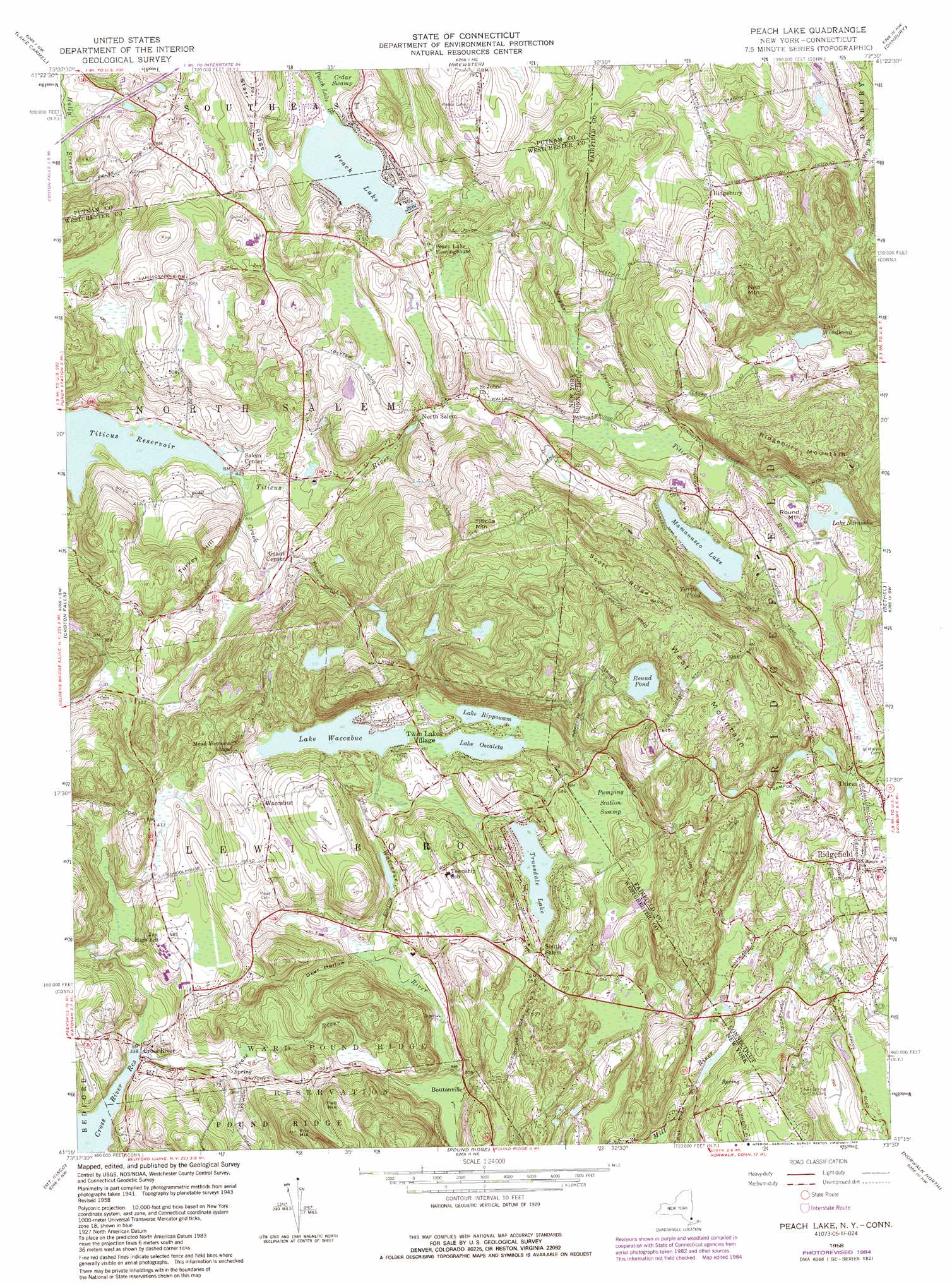
Peach Lake Topo Map New York
To zoom in, hover over the map of Peach Lake
USGS Topo Quad 41073c5 - 1:24,000 scale
| Topo Map Name: | Peach Lake |
| USGS Topo Quad ID: | 41073c5 |
| Print Size: | ca. 21 1/4" wide x 27" high |
| Southeast Coordinates: | 41.25° N latitude / 73.5° W longitude |
| Map Center Coordinates: | 41.3125° N latitude / 73.5625° W longitude |
| U.S. States: | NY, CT |
| Filename: | o41073c5.jpg |
| Download Map JPG Image: | Peach Lake topo map 1:24,000 scale |
| Map Type: | Topographic |
| Topo Series: | 7.5´ |
| Map Scale: | 1:24,000 |
| Source of Map Images: | United States Geological Survey (USGS) |
| Alternate Map Versions: |
Peach Lake NY 1945 Download PDF Buy paper map Peach Lake NY 1958, updated 1960 Download PDF Buy paper map Peach Lake NY 1958, updated 1965 Download PDF Buy paper map Peach Lake NY 1958, updated 1972 Download PDF Buy paper map Peach Lake NY 1958, updated 1981 Download PDF Buy paper map Peach Lake NY 1958, updated 1984 Download PDF Buy paper map Peach Lake NY 1958, updated 1988 Download PDF Buy paper map Peach Lake NY 1958, updated 1988 Download PDF Buy paper map Peach Lake NY 1998, updated 2001 Download PDF Buy paper map Peach Lake NY 2010 Download PDF Buy paper map Peach Lake NY 2013 Download PDF Buy paper map Peach Lake NY 2016 Download PDF Buy paper map |
1:24,000 Topo Quads surrounding Peach Lake
Hopewell Junction |
Poughquag |
Pawling |
New Milford |
Roxbury |
Oscawana Lake |
Lake Carmel |
Brewster |
Danbury |
Newtown |
Mohegan Lake |
Croton Falls |
Peach Lake |
Bethel |
Botsford |
Ossining |
Mount Kisco |
Pound Ridge |
Norwalk North |
Westport |
White Plains |
Glenville |
Stamford |
Norwalk South |
Sherwood Point |
> Back to 41073a1 at 1:100,000 scale
> Back to 41072a1 at 1:250,000 scale
> Back to U.S. Topo Maps home
Peach Lake topo map: Gazetteer
Peach Lake: Bridges
Mill's Bridge elevation 103m 337′Peach Lake: Crossings
Rundle's Corners elevation 170m 557′Peach Lake: Dams
Lake Naraneka Dam elevation 177m 580′Lake Windwing Dam elevation 192m 629′
Mamanasco Lake Dam elevation 173m 567′
Shadow Lake Dam elevation 153m 501′
Peach Lake: Islands
Chauncey Island elevation 179m 587′Peach Lake: Lakes
Lake Rippowam elevation 145m 475′Lake Waccabuc elevation 144m 472′
Lake Windwing elevation 181m 593′
Mamanasco Lake elevation 176m 577′
Oscaleta Lake elevation 144m 472′
Peach Lake elevation 161m 528′
Round Pond elevation 237m 777′
Truesdale Lake elevation 152m 498′
Turtle Pond elevation 201m 659′
Peach Lake: Parks
Ballard Green elevation 217m 711′Ballard Park elevation 218m 715′
Fitzgerald Field elevation 184m 603′
Long Pond Preserve elevation 145m 475′
Richardson Park elevation 181m 593′
Sachem Hill Field elevation 269m 882′
West Mountain Refuge elevation 263m 862′
Peach Lake: Populated Places
Boutonville elevation 129m 423′Cross River elevation 103m 337′
Dingle elevation 189m 620′
Grant Corner elevation 117m 383′
North Salem elevation 154m 505′
Peach Lake elevation 171m 561′
Ridgebury elevation 190m 623′
Salem Center elevation 103m 337′
South Salem elevation 165m 541′
Titicus elevation 186m 610′
Truesdale Lake elevation 165m 541′
Twin Lakes Village elevation 151m 495′
Waccabuc elevation 169m 554′
Peach Lake: Post Offices
North Salem Post Office elevation 115m 377′Ridgefield Post Office elevation 222m 728′
Peach Lake: Reservoirs
Hemlock Lake elevation 221m 725′Lake Naraneka elevation 179m 587′
Lake Windwing elevation 192m 629′
Laurel Lake elevation 168m 551′
Mamanasco Pond elevation 173m 567′
Pine Lake elevation 166m 544′
Shadow Lake elevation 153m 501′
Spruce Lake elevation 183m 600′
Whatmores Lake elevation 183m 600′
Peach Lake: Ridges
Scott Ridge elevation 298m 977′Peach Lake: Streams
Crook Brook elevation 99m 324′Mill River elevation 187m 613′
Mopus Brook elevation 151m 495′
Mopus Brook elevation 151m 495′
Titicus River elevation 99m 324′
Titicus River elevation 99m 324′
Waccabuc River elevation 124m 406′
Peach Lake: Summits
East Long Pond Mountain elevation 296m 971′Fox Hill elevation 223m 731′
Long Pond Mountain elevation 262m 859′
Ned Mountain elevation 284m 931′
Pell Hill elevation 192m 629′
Round Mountain elevation 189m 620′
Seth Low Mountain elevation 283m 928′
Titicus Mountain elevation 282m 925′
Turkey Hill elevation 186m 610′
West Mountain elevation 285m 935′
Peach Lake: Swamps
Pumping Station Swamp elevation 160m 524′Peach Lake: Valleys
Deer Hollow elevation 127m 416′Peach Lake digital topo map on disk
Buy this Peach Lake topo map showing relief, roads, GPS coordinates and other geographical features, as a high-resolution digital map file on DVD:
New York, Vermont, Connecticut & Western Massachusetts
Buy digital topo maps: New York, Vermont, Connecticut & Western Massachusetts