Mohegan Lake Topo Map New York
To zoom in, hover over the map of Mohegan Lake
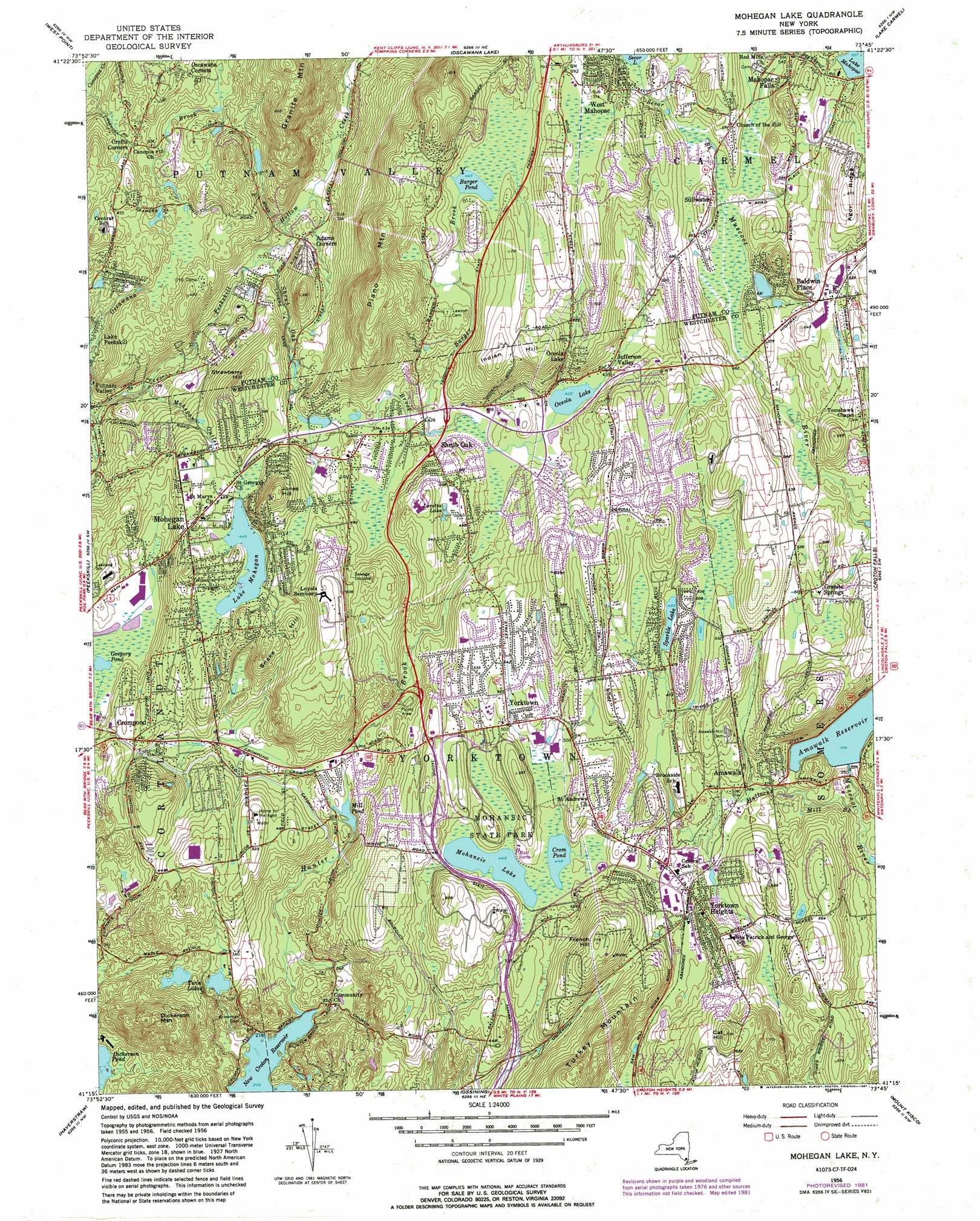
USGS Topo Quad 41073c7 - 1:24,000 scale
| Topo Map Name: | Mohegan Lake |
| USGS Topo Quad ID: | 41073c7 |
| Print Size: | ca. 21 1/4" wide x 27" high |
| Southeast Coordinates: | 41.25° N latitude / 73.75° W longitude |
| Map Center Coordinates: | 41.3125° N latitude / 73.8125° W longitude |
| U.S. State: | NY |
| Filename: | o41073c7.jpg |
| Download Map JPG Image: | Mohegan Lake topo map 1:24,000 scale |
| Map Type: | Topographic |
| Topo Series: | 7.5´ |
| Map Scale: | 1:24,000 |
| Source of Map Images: | United States Geological Survey (USGS) |
| Alternate Map Versions: |
Mohegan Lake NY 1956, updated 1958 Download PDF Buy paper map Mohegan Lake NY 1956, updated 1964 Download PDF Buy paper map Mohegan Lake NY 1956, updated 1973 Download PDF Buy paper map Mohegan Lake NY 1956, updated 1981 Download PDF Buy paper map Mohegan Lake NY 1956, updated 1987 Download PDF Buy paper map Mohegan Lake NY 2010 Download PDF Buy paper map Mohegan Lake NY 2013 Download PDF Buy paper map Mohegan Lake NY 2016 Download PDF Buy paper map |
1:24,000 Topo Quads surrounding Mohegan Lake
Newburgh |
Wappingers Falls |
Hopewell Junction |
Poughquag |
Pawling |
Cornwall |
West Point |
Oscawana Lake |
Lake Carmel |
Brewster |
Popolopen Lake |
Peekskill |
Mohegan Lake |
Croton Falls |
Peach Lake |
Thiells |
Haverstraw |
Ossining |
Mount Kisco |
Pound Ridge |
Park Ridge |
Nyack |
White Plains |
Glenville |
Stamford |
> Back to 41073a1 at 1:100,000 scale
> Back to 41072a1 at 1:250,000 scale
> Back to U.S. Topo Maps home
Mohegan Lake topo map: Gazetteer
Mohegan Lake: Capes
Cedar Point elevation 139m 456′Mohegan Lake: Lakes
Barger Pond elevation 196m 643′Crom Pond elevation 136m 446′
Gregory Pond elevation 94m 308′
Lake Mohegan elevation 135m 442′
Loretta Lake elevation 158m 518′
Mill Pond elevation 90m 295′
Mohansic Lake elevation 136m 446′
Oceola Lake elevation 128m 419′
Sparkle Lake elevation 148m 485′
Twin Lakes elevation 113m 370′
Mohegan Lake: Parks
Downing Park elevation 150m 492′Hemlock Brook Preserve elevation 102m 334′
Koegel Park elevation 200m 656′
Mohansic State Park elevation 139m 456′
Shrub Oak Memorial Park elevation 127m 416′
Yorktown Memorial Park elevation 125m 410′
Mohegan Lake: Populated Places
Adams Corners elevation 77m 252′Amawalk elevation 126m 413′
Baldwin Place elevation 186m 610′
Crofts Corners elevation 123m 403′
Crompond elevation 128m 419′
Dixie elevation 66m 216′
Granite Springs elevation 157m 515′
Jefferson Valley elevation 140m 459′
Jefferson Village elevation 134m 439′
Lake Mohegan elevation 159m 521′
Mahopac Falls elevation 176m 577′
Mohegan Lake elevation 144m 472′
Oceola Lake elevation 176m 577′
Oregon elevation 44m 144′
Putnam Valley elevation 51m 167′
Shrub Oak elevation 134m 439′
Stillwater elevation 173m 567′
West Mahopac elevation 210m 688′
Yorktown elevation 154m 505′
Yorktown Heights elevation 150m 492′
Mohegan Lake: Post Offices
Amawalk Post Office elevation 115m 377′Shrub Oak Post Office elevation 130m 426′
Mohegan Lake: Reservoirs
Amawalk Reservoir elevation 121m 396′Mohegan Lake: Ridges
Agor Ridge elevation 264m 866′Flewellen Ridge elevation 173m 567′
Mohegan Lake: Streams
Barger Brook elevation 128m 419′Hallocks Mill Brook elevation 95m 311′
Hunter Brook elevation 61m 200′
Mohegan Outlet elevation 42m 137′
Oscawana Brook elevation 37m 121′
Secor Brook elevation 157m 515′
Shrub Oak Brook elevation 66m 216′
Mohegan Lake: Summits
Cat Hill elevation 221m 725′Dickerson Mountain elevation 237m 777′
French Hill elevation 236m 774′
Indian Hill elevation 231m 757′
Jones Hill elevation 219m 718′
Piano Mountain elevation 299m 980′
Snake Hill elevation 180m 590′
Strawberry Hill elevation 197m 646′
Mohegan Lake: Swamps
Cedar Swamp elevation 139m 456′Mohegan Lake digital topo map on disk
Buy this Mohegan Lake topo map showing relief, roads, GPS coordinates and other geographical features, as a high-resolution digital map file on DVD:
New York, Vermont, Connecticut & Western Massachusetts
Buy digital topo maps: New York, Vermont, Connecticut & Western Massachusetts